Report on Lascar (Chile) — July 1994

Bulletin of the Global Volcanism Network, vol. 19, no. 7 (July 1994)
Managing Editor: Richard Wunderman.
Lascar (Chile) Moderate short-lived eruption sends plume over Argentina
Please cite this report as:
Global Volcanism Program, 1994. Report on Lascar (Chile) (Wunderman, R., ed.). Bulletin of the Global Volcanism Network, 19:7. Smithsonian Institution. https://doi.org/10.5479/si.GVP.BGVN199407-355100
Lascar
Chile
23.37°S, 67.73°W; summit elev. 5592 m
All times are local (unless otherwise noted)
Renewed Vulcanian activity during 20-26 July generated plumes up to ~9,000 m altitude, ~4,000 m above the summit . . . . On 20 July at 1630 a grayish column 400-500 m high was emitted from the crater. The next day at 1230 a brownish eruptive column rose 3,000-4,000 m and immediately drifted NE. Very fine ashfall was reported in Salar de Olaroz in the Argentine Puna, 120 km NE of the vent. At 1430 on 23 July another eruption plume to a height of 3,000-4,000 m was blown NNE. No ashfall was reported in the Argentine Puna following this activity.
A single short-lived Vulcanian explosion at about 1200 on 26 July generated a column and NNE-trending plume that soon detached from the volcano; prevailing high-level winds then shifted the plume toward the E. Witnesses from Toconao (35 km NW) and San Pedro de Atacama (70 km NW) reported a moderate explosion followed by a dark-colored mushroom-shaped column that slowly rose to 4,000 m height. Pilots from Aerolineas Argentinas, AeroMonterrey, and Lineas Aereas de Chile reported to the Argentina National Metereological Service that the plume, ~30 km wide and 200 km long, reached an altitude of 9,000 m. Ashfall was only reported in areas close to the volcano. No ashfall was reported in the small village of Catua along the Chilean-Argentine border, 80 km E of Lascar. Immediately after the eruption the volcano showed very diminished activity, with weak white fumarolic plumes that hardly rose above the crater rim. From 27 July to 4 August the volcano exhibited normal fumarolic activity.
Infrared images of the 26 July ash cloud were captured by Raúl Rodano and Luis Ganz from the Meteosat 3 satellite (figure 22). An image taken at 1346 on 26 July showed an ESE-directed plume 50 x 20 km in size, reaching an altitude between 3,600 and 5,400 m (figure 22, top). At 1523 another image showed a 130-km-long plume with the trailing edge located 60 km from Lascar (figure 22, middle). On the E side of the plume, a core (40 km in diameter) developed vertically and reached ~7,000 m altitude. The lower levels of the plume were oriented ESE, following the general atmospheric circulation. Because of wind-shear between 5,400 and 7,000 m, the plume was reoriented NNE by upper-level winds (200°- 70 km/hour). On the image taken at 1631, the plume is 180 km long and 100 km from the source (figure 22, bottom). Based on analysis of this imagery, the NNE-oriented E end of the plume reached an estimated maximum height of 7,500 m. Although the sky was cloudy by 1830, scattered parts of the NNE-oriented plume could be seen 80 km E of Jujuy, Argentina, drifting E at 80 km/hour at an estimated altitude of 4,500 m. With frame animation it was possible to discern the dispersed plume reaching Presidente Roque Saenz Pena city, 800 km E of Lascar, at 2009 on 26 July.
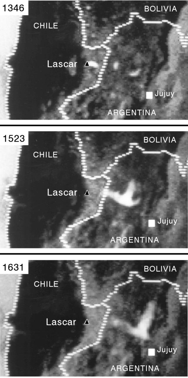 |
Figure 22. Infrared images of the 26 July 1994 plume from Lascar (white area) taken from the Meteosat 3 satellite. At 1346 (top) the small plume (50 x 20 km) was moving ESE. By 1523 (middle) the trailing edge of the 130-km-long detached plume was located 60 km from the volcano. On the image taken at 1631 (bottom), the plume was 100 km from the source, 180 km long, and the E end was oriented NNE. Approximate location of Lascar is shown by the black triangle; Jujuy, Argentina, is indicated by the white square. Courtesy of Raúl Rodano and Luis Ganz. |
These eruptions comprise the fourth period of Vulcanian activity following the large subplinian eruption of 19-20 April 1993. Eruptions were also reported in August and December 1993, and February 1994. All are thought to have been caused by blockage of the degassing magmatic system due to collapse of the dome formed in the late stages of the April 1993 eruption. The present morphology of the crater is unknown, although this renewed activity suggests further subsidence of the crater floor due to conduit degassing. Lascar, the most active volcano of the northern Chilean Andes, contains five overlapping summit craters along a NE trend. Prominent lava flows descend its NW flanks.
Reference. Gardeweg P., M.C., 1994, La Explosion del 26 de Julio, 1994, X Informe sobre el comportamiento del Volcan Lascar: Informe Inedito, Biblioteca Servicio Nacional de Geologia y Mineria, 4 p.
Geological Summary. Láscar is the most active volcano of the northern Chilean Andes. The andesitic-to-dacitic stratovolcano contains six overlapping summit craters. Prominent lava flows descend its NW flanks. An older, higher stratovolcano 5 km E, Volcán Aguas Calientes, displays a well-developed summit crater and a probable Holocene lava flow near its summit (de Silva and Francis, 1991). Láscar consists of two major edifices; activity began at the eastern volcano and then shifted to the western cone. The largest eruption took place about 26,500 years ago, and following the eruption of the Tumbres scoria flow about 9000 years ago, activity shifted back to the eastern edifice, where three overlapping craters were formed. Frequent small-to-moderate explosive eruptions have been recorded since the mid-19th century, along with periodic larger eruptions that produced ashfall hundreds of kilometers away. The largest historical eruption took place in 1993, producing pyroclastic flows to 8.5 km NW of the summit and ashfall in Buenos Aires.
Information Contacts: M. Gardeweg, SERNAGEOMIN, Santiago; J. Viramonte, R. Becchio, I. Petrinovic, and R. Arganaraz, Instituto Geonorte Univ Nacional de Salta, Argentina; B. Coira and A. Perez, Instituto de Geologia Universidad de Jujuy, Argentina; R. Rodano and L. Ganz, Aerolineas Argentinas Weather Division, Buenos Aires, Argentina; H. Corbella, CONICET - Argentine Museum of Natural Sciences, Buenos Aires.