Report on Popocatepetl (Mexico) — October 1994

Bulletin of the Global Volcanism Network, vol. 19, no. 10 (October 1994)
Managing Editor: Richard Wunderman.
Popocatepetl (Mexico) SO2 flux increases since May; increase in number of seismic events
Please cite this report as:
Global Volcanism Program, 1994. Report on Popocatepetl (Mexico) (Wunderman, R., ed.). Bulletin of the Global Volcanism Network, 19:10. Smithsonian Institution. https://doi.org/10.5479/si.GVP.BGVN199410-341090
Popocatepetl
Mexico
19.023°N, 98.622°W; summit elev. 5393 m
All times are local (unless otherwise noted)
During late-October, Carlos Valdéz-González and co-workers identified a sudden, prominent (roughly 1.6- to 10-fold) increase in daily earthquakes compared to previous months (figure 4). Station locations and the terms "A-", "B-", and "AB-type" were previously defined (19:1-2). Although Figure 4 shows only B-type events, the other two types remained at 0-1 events/day during September and October. Prior to mid-October, the daily count of B-type events generally remained below 10, but by 28 October they climbed to 26. The B-type events for the first half of 1994 were previously published (19:06). Carlos Valdés-González noted that this was the fastest rate of increase in the last 23 months.
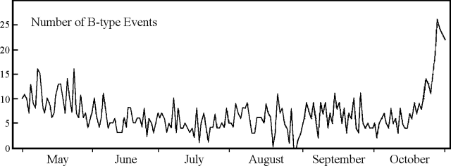 |
Figure 4. Daily number of B-type seismic events at Popocatépetl, May-October, 1994. Courtesy of Carlos Valdés-González, UNAM. |
Ignacio Galindo contributed the following report.
"A new series of ultraviolet absorption correlation spectrometry (COSPEC) measurements was made by scientists from Univ de Colima (A. González, J.C. Gavilanes and C. Navarro), UNAM (H. Hidalgo) and USGS (T. Casadevall) on 5 November from a rented Cessna 310 airplane. The measurements were requested by the Secretaría de Gobernación through the Centro Nacional para la Prevención de Desastres (CENAPRED). Between 1024 and 1148 on 5 November, the plume was traversed 12 times at an altitude between 3,539 and 4,545 m a.s.l. [above sea level] in partially cloudy conditions. The aircraft's global positioning system (GPS) computed the wind speed independently for each traverse. These measurements were each used to make individual SO2 flux calculations, removing the need to use average wind speed (19:08). This procedure is advantageous when the wind speed varies significantly. SO2 data were sent to a datalogger, besides the typical COSPEC strip chart. All the recorded data were transferred into a personal computer where evaluation software produced the final SO2 results together with a statistical analysis of the time series. A manual SO2 determination using data from strip chart records (as reported in 19:08) was also made by C. Navarro; it reproduced the average values within 2.4% on average.
"The SO2 flux on 5 November ranged from 924 to 1,877 metric tons/day (t/d), with a standard deviation of 285 t/d and an average value of 1,261 t/d. Table 1 compares our recent measurements with those of 4 May, which were determined with the same methodology (19:04). The SO2 flux increased substantially between 4 May and 5 November. Although our determinations show absolute values less than those reported by other authors (19:1 & 8), both data sets show increased SO2 flux."
Table 1. Popocatépetl SO2 flux measurements on 4 May and 5 November 1994. Courtesy of Ignacio Galindo, Univ de Colima.
| Date | Average (t/d) | Maximum (t/d) | Minimum (t/d) | STD |
| 04 May 1994 | 900 | 1,462 | 485 | 232 |
| 05 Nov 1994 | 1,261 | 1,877 | 924 | 285 |
| Difference: | 361 | 415 | 439 | |
| Percentage: | 40 | 28 | 91 | |
Geological Summary. Volcán Popocatépetl, whose name is the Aztec word for smoking mountain, rises 70 km SE of Mexico City to form North America's 2nd-highest volcano. The glacier-clad stratovolcano contains a steep-walled, 400 x 600 m wide crater. The generally symmetrical volcano is modified by the sharp-peaked Ventorrillo on the NW, a remnant of an earlier volcano. At least three previous major cones were destroyed by gravitational failure during the Pleistocene, producing massive debris-avalanche deposits covering broad areas to the south. The modern volcano was constructed south of the late-Pleistocene to Holocene El Fraile cone. Three major Plinian eruptions, the most recent of which took place about 800 CE, have occurred since the mid-Holocene, accompanied by pyroclastic flows and voluminous lahars that swept basins below the volcano. Frequent historical eruptions, first recorded in Aztec codices, have occurred since Pre-Columbian time.
Information Contacts: Guillermo González-Pomposo1, Carlos Valdés-González, and A. Arciniega-Ceballos, Departamento de Sismología y Volcanología, Instituto de Geofísica, UNAM; Ignacio Galindo, Arturo González, J.C. Gavilanes, Carlos Navarro, CUICT-Univ de Colima; Hugo Delgado, Instituto de Geofísica, UNAM; T. J. Casadevall, USGS; 1Also at Benmérita Univ Autónoma de Puebla.