Report on Galeras (Colombia) — March 1995

Bulletin of the Global Volcanism Network, vol. 20, no. 3 (March 1995)
Managing Editor: Richard Wunderman.
Galeras (Colombia) Earthquake on 4 March kills six people and precedes more felt earthquakes
Please cite this report as:
Global Volcanism Program, 1995. Report on Galeras (Colombia) (Wunderman, R., ed.). Bulletin of the Global Volcanism Network, 20:3. Smithsonian Institution. https://doi.org/10.5479/si.GVP.BGVN199503-351080
Galeras
Colombia
1.22°N, 77.37°W; summit elev. 4276 m
All times are local (unless otherwise noted)
According to INGEOMINAS, at 1823 on 4 March a M 4.7-4.8 earthquake struck Galeras's NE flank (figure 73). The USGS National Earthquake Information Center (NEIC) reported the earthquake as M 4.5. The preliminary location for the event was provided by the Observatory's network (stations 0.9, 1.6, 2.1, 11.0, 5.0, 5.5 and 9.0 km from the active crater); the hypocenter (at 1.26°N, 77.33°W) was ~4 km NE of the active cone at 13 km depth. Signals from the earthquake saturated all of the stations in the local network; the earthquake itself was clearly felt in SW Colombia's in the E part of the Department of Nariño.
 |
Figure 73. Isoseismal map of the 4 March earthquake near Galeras prepared using the European microseismic scale. Courtesy of INGEOMINAS. |
During the 3 hours following the event there were 130 aftershocks, at least 11 felt, the majority with magnitudes between 2.6 and 3.6 (figures 74 and 75). Subsequent events tended to decrease in magnitude, but some were still felt near the epicenter. Two relatively strong aftershocks took place 6 days after the initial earthquake (at 0017 and 0632 on 10 March), M 4.1 and 3.8, setting off a second swarm of declining aftershocks (figure 75). During 4-31 March approximately 1,440 aftershocks took place from the same area (figures 74, 75, and 76). At least 67 aftershocks were felt; the last, at 0804 on 29 March, was M 2.1.
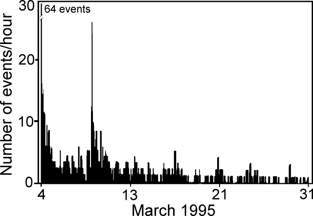 |
Figure 74. Histogram showing the number of seismic events/hour following the 4 March earthquake near Galeras. Courtesy of INGEOMINAS. |
 |
Figure 75. Plot of earthquake magnitude with respect to time following the 4 March earthquake near Galeras. Calculated magnitude values (M) were based on a function of the earthquakes duration. The graphic includes only earthquakes whose amplitude is >=2.5 m/sec. This value was the minimum classification parameter at "Crater-2," a station 1.6 km S of the active crater. Courtesy of INGEOMINAS. |
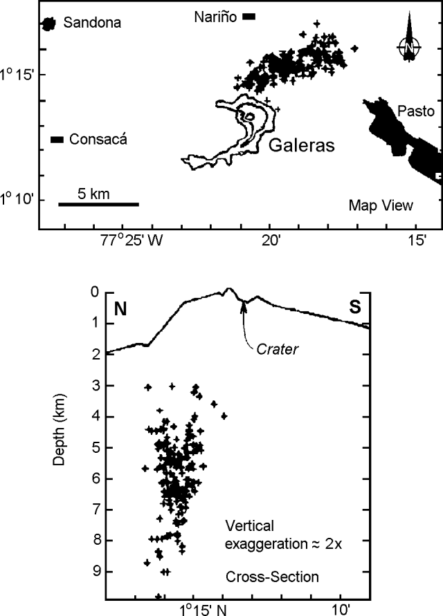 |
Figure 76. Map showing seismicity near Galeras (top), and vertical N-S cross-section (bottom) showing the pattern of located earthquakes, 4-31 March. Courtesy of INGEOMINAS. |
Large measured tilt coincided with the main shock. The maximum tilt changes were registered by electronic tiltmeters as 3 µrad, and by short leveling line vectors as 15 µrad. The tiltmeters returned to their previous levels almost immediately; the short leveling line vectors returned in a few days.
The epicentral area basically corresponded to the rural municipalities of Pasto . . . and other adjacent towns (figures 73 and 76), settlements with houses that were for the most part single-level and of rudimentary adobe construction. The houses were seriously affected and INGEOMINAS reported that some were ". . . damaged so badly as to be ready to collapse, also with caved-in roofs and loose tiles, that made living in them impossible and insecure. In the city of Pasto the constructions most affected were the antiquated structures . . . ." INGEOMINAS also related that: "In one neighborhood to the N of the city, the principal earthquake caused the loosening of blocks on a slope that fell on a nearby house, causing its destruction and killing 6 of its inhabitants. Other effects related to the main shock and its aftershocks were loud noises and small landslides on slopes near the wagon trails close to the epicentral region." NEIC reports stated that eight people were killed and four were injured. They mentioned that there were ~250 aftershocks, and that over 50 houses were damaged or destroyed, many by seismically triggered mudslides.
INGEOMINAS noted that previous seismic swarms had similar or adjacent epicenters. In both April and November 1993 swarms of M < 4.5 were felt in the same epicentral region, although the 4 March earthquake was itself larger and associated with more energetic, more numerous, and more frequent aftershocks. Soon after the earthquake, on 6, 11, and 19 March, the local seismic system around Galeras registered unusual, high-amplitude seismic events possibly associated with an explosive eruption. During these events signal amplitude grew for a few seconds, rapidly escalated, and then quickly decayed, the entire event lasting perhaps two minutes. The high-amplitude part of the event generally caused many of the stations in the local system to saturate. Associated with these high amplitude events, people located ~6-9 km from the volcano reported loud noises suggesting that an explosive eruption may have occurred. This hypothesis was unconfirmed due to poor visibility.
Other than these large earthquakes at Galeras, low- and high-frequency events and "butterfly" events remained low. The high- and low-frequency events were chiefly located at shallow depths (<3 km) near to, or just W of, the active cone. During the last days of March there were 12 "screw-type" events (<=3 events/day). The screw-type events had durations of up to 85 seconds and multiple constituent frequencies in the 1.5-7 Hz range. Screw-type events were registered before the majority of the 1992-1993 eruptive events and before some 1994-1995 degassing episodes.
As in previous months, the concentrations of SO2 obtained by mobile, ground-based correlation spectroscopy (COSPEC) remained <100 t/d. The volcano was clearly visible on various occasions, particularly at the beginning of the month, but the gas column was only visible a few times from the city of Pasto. At these times the column had heights under 300 m, and emission were coming from the W sector of the volcano. Sometimes, when the column was blown E, sulfurous odors were reported.
M. Calvache recently sent us color photographs showing Galeras's summit morphology in December 1991, March 1993, and March 1995. The December 1991 image was most suitable for black-and-white reproduction (figure 77).
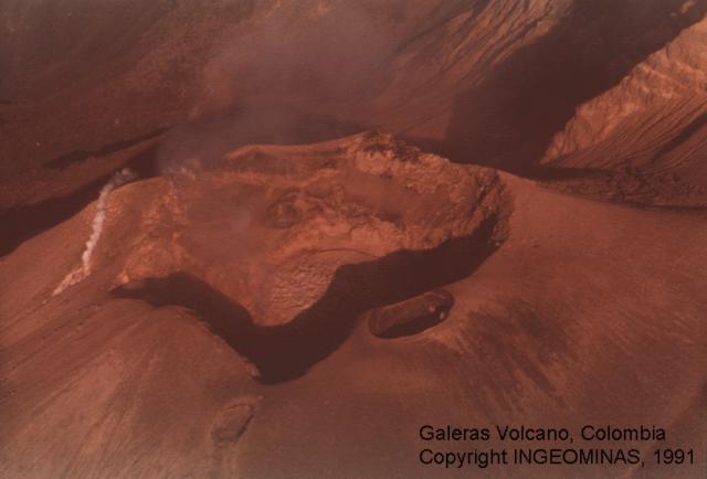 |
Figure 77. Galeras's summit area viewed from the SE in December 1991. Deformes fumarole (left center) and the small elliptical El Pinta crater (right center on crater rim) are still present in 1995 (see sketch map in 20:2). CCourtesy of INGEOMINAS. |
Geological Summary. Galeras, a stratovolcano with a large breached caldera located immediately west of the city of Pasto, is one of Colombia's most frequently active volcanoes. The dominantly andesitic complex has been active for more than 1 million years, and two major caldera collapse eruptions took place during the late Pleistocene. Long-term extensive hydrothermal alteration has contributed to large-scale edifice collapse on at least three occasions, producing debris avalanches that swept to the west and left a large open caldera inside which the modern cone has been constructed. Major explosive eruptions since the mid-Holocene have produced widespread tephra deposits and pyroclastic flows that swept all but the southern flanks. A central cone slightly lower than the caldera rim has been the site of numerous small-to-moderate eruptions since the time of the Spanish conquistadors.
Information Contacts: INGEOMINAS, Pasto; NEIC.