Report on Fogo (Cabo Verde) — April 1995
Bulletin of the Global Volcanism Network, vol. 20, no. 4 (April 1995)
Managing Editor: Richard Wunderman.
Fogo (Cabo Verde) Fire fountains continue but lava extrusion rate declines
Please cite this report as:
Global Volcanism Program, 1995. Report on Fogo (Cabo Verde) (Wunderman, R., ed.). Bulletin of the Global Volcanism Network, 20:4. Smithsonian Institution. https://doi.org/10.5479/si.GVP.BGVN199504-384010
Fogo
Cabo Verde
14.95°N, 24.35°W; summit elev. 2829 m
All times are local (unless otherwise noted)
On 2-3 April a fissure eruption began on Fogo Island from the SW flank of Pico cone (Fogo Peak) within the 8-km-diameter Cha Caldera (BGVN 20:03). During the initial stage of the eruption there was a burst or jetting of gas, followed by ejection of large blocks and fire fountaining. A lava flow cut off the main road to local villages by the morning of 3 April, and ash fell on the island. Approximately 1,300 residents in the caldera were evacuated.
Volcanologists from the United States, Portugal, and France were requested by the Cape Verdean government to help monitor and evaluate the activity. João Gaspar (Universidade dos Açores) and colleagues observed the activity until 11 April. U.S. Geological Survey (USGS) volcanologists, assisted by Cape Verdean geologists, installed a seismic station and monitored the eruption during 10-25 April. Additional information about the vent activity during 14-19 April was provided by Henry Gaudru and members of the Société Volcanologique Européenne who visited the volcano. François Le Guern (CNRS France) monitored the volcano on 25-27 April.
Summary of activity, 3-16 April. Detailed activity reports through 16 April have already been published (BGVN 20:03). Seven vents were active on the first day of the eruption, with fire-fountains feeding pahoehoe lava flows, ejection of volcanic bombs, and a gas-and-ash plume 2,000 m high. A scoria cone was soon built, from which lava flows were directed SW before turning NW towards the caldera wall. As the main aa flow approached the caldera scarp it turned N, covering the settlement of Boca de Fonte by 9 April and approaching Portela and Bangaeira (see map in BGVN 20:03). Less vigorous fire fountaining continued on 12-16 April, and fed new lava flows on top of the previous aa flow. There were occasional periods of Strombolian spatter ejections. By late on 16 April the remobilized flow-front was ~4 km from the source vent and only a little more than 500 m from the nearest house in Portela.
Activity during 17-25 April. Except where noted otherwise, the following observations are from the USGS team and their Cape Verdean colleagues. Activity continued on 17 April with little change at the vent. Spatter fountains rose 100-150 m, and the cone was ~150 m high. Volcanic tremor amplitude remained moderate to strong. The N end of the aa flow advanced ~150 m during 16-17 April, to ~420 m SW of the nearest house in Portela, and the E side of the flow moved 20-50 m ENE. The W side of the flow advanced >100 m and by 1430 had crushed half of the winery at Boca de Fonte. After these breakouts blocked the access road a new road was created through agricultural fields, forcing residents rescuing belongings to walk an additional 500 m. Flow movement was barely perceptible after 1430 and largely restricted to short spiny pahoehoe and aa oozes at flow margins, although lava output at the vent was unchanged.
Between 1630 and 2030 on 17 April, Gaudru noted that Strombolian explosions were less vigorous and that the main lava channel had widened from 2-3 m to 5-6 m because of lava-block obstructions. The W flank of the cone was also covered by cinders. Explosive activity increased at 1900, sending incandescent ejecta 150-200 m above the rim of the cone. A flame visible behind the E part of the cone was apparently coming from a small vent on the upper E flank. At 2000 explosions began ejecting material >300 m W instead of vertically.
Tremor amplitude began to increase around 0650 on 18 April, and at 0740 became continuous at about twice the previous amplitude. Eruptive style changed from fire fountaining to Strombolian activity, with spatter discharged by loud gas bursts every 3-8 seconds. Lava production increased during the morning; by noon the lava was largely pahoehoe in the upper 300 m of the channel. Estimated channel dimensions and the speed of lava in it yielded production rates of 4-8.5 x 10⁶ m3/day. Microearthquakes were intermittent, with three larger events (all M <1) at 1314 and 1803 on 18 April, and at 0426 on 19 April.
Seismograph records showed that activity during 0110-0320 and 0426-0610 on 19 April was characterized by strong explosive bursts, which were interpreted to be vent clearing episodes after pieces of the cone and newly erupted spatter closed the conduit. After 0610 the seismicity indicated a return to fire-fountaining. A favorable wind direction permitted a close approach to the vent and lava channel to verify the volume estimate, but the lava appeared somewhat more viscous/sluggish. There was no measureable movement at the edges of the aa flow on 19 April after <3 m of movement the day before, however, lava continued ponding in its channel near the middle of the flow.
Observations made by Gaudru from 1230 on 18 April until 1230 on 19 April indicated that activity remained strong with incandescent fragments rising >200 m and loud detonations. Explosions every 1-2 seconds, accompanied by earthquakes, ejected particles ranging in size up to >1 m3. Gas outbursts were more intense, and black plumes hovered over the active cone. Partial obstruction of the crater caused a larger explosion at 1745 on 18 April that sent gas and cinders 500-600 m high. After several seconds of quiet, stronger explosive activity began again with sounds that shook the ground. The upper E flank crater sent an intermittent orange-red flame 10-15 m high for several hours during this period, higher than previous days. Eruptive activity observed by the Gaudru group became more regular at 0100 on 19 April, when an intense episode began that sent lava fountains >300 m high for several hours. Explosive activity began again at dawn that lasted throughout the morning of 19 April.
Tremor amplitude on 19 April changed from moderate-strong to moderate around 1500, when Strombolian activity reverted back to fire fountains. Fire fountain heights diminished somewhat on 20 April, rising generally 20-50 m above the vent. Intermittent Strombolian activity continued with more energetic bursts that sent viscous lava clots >160 m high. A full lava channel 200 m W of the vent appeared much like it did the day before. A new aa lobe was moving sluggishly on top of the earlier flow, and by 1700 its distal end was ~600 m from the N end of the flow, nearest to Portela.
Strong Strombolian activity on 21 April produced loud bursts of viscous spatter 50-150 m high. A levee formed on top of the spillway adjacent to the vent behind which fountains rose 10-20 m, often interrupted by explosions. Lava exited through a hole in the bottom of the levee into a W-flank channel roofed over in two places. At the bottom of the spillway the lava entered a sinuous channel, moving W and NW on top of the previously emplaced flow; this channel remained full all day. The volume of lava erupted was similar to values for the past several days, 4-8 x 10⁶ m3/day. The 160-m-high cinder cone was no longer increasing significantly in height, but impact craters as large as 5 m wide and 1 m deep, created by fall of spatter bombs 0.5-2 m across, littered its flanks and parts of the cinder-mantled caldera floor up to 200 from the vent. As is common during eruptions of viscous mafic lava, the inner walls of the cone collapsed into the conduit, resulting in explosive vent-clearing episodes. The overriding aa flow on the E side of the N flow moved another 6 m N during 21 April.
Volcanic tremor on 21-22 April continued at moderate to strong levels, punctuated by frequent sonic bursts. Noisy Strombolian bursts sent clots of spatter over the top of the cone and onto its flanks. The volume of lava flowing into the channel was similar to that of 21 April. At noon, lava from a new crack on the N flank of the cone flowed 150 m N and soon stagnated. The aa flow advanced 2 m W near the new end of the road (150 m S of Boca de Fonte), and ~3 m NE on the E side of the N flow. Most of the volume of lava was concentrated in an aa lobe that was very slowly overriding the earlier flow. This lobe locally was at least 15 m thick and covered an estimated 75% of the existing flow field.
Activity on 23 April was spectacular. Deafening explosions from four discrete vents rocked the caldera all day; at times the ground was in continuous motion from concussion waves. The overriding aa lobe only moved ~4 m N on the E side of the main aa flow. However, early in the afternoon a new vent opened at the NW base of the cone. By 1700 lava was flowing W from this vent, and by 1807 spatter ejected to heights of 10-15 m was visible. Pahoehoe lava flowed on top of older aa and soon joined the large stagnating aa channel 500-700 m from the main cone. For the preceding 4 days the seismograph had recorded sonic bursts and microseisms. It was believed that shock waves associated with the bursts caused several fractures on the cone. One of these cracks provided a new pathway for lava to exit the cone, thus robbing the main channel of most of its lava. Strong volcanic tremor was interrupted by frequent sonic bursts.
Moderate to strong tremor continued on 24 April. At the main cone in the morning, Strombolian bursts every few seconds sent spatter fragments onto the cone's flanks. In the afternoon, the intense sonic bursts and Strombolian activity that had characterized the past few days were absent. A gray-black plume, laden with fine-grained (<1 mm) juvenile particles and volcanic gases, rose to heights approaching 1.5 km above the caldera floor. Lava in relatively low volumes continued to erupt from the NW base of the cone, moving horizontally from the cone into a tear-shaped cavity. Once the lava reached the surface, degassing occurred, at times intensely enough to drive low-level Strombolian activity. The amount of visible degassing rivaled the plume from the main vent. The depression and lava chute were 25-35 m long and 1-2 m wide. Lava moving at 1 m/s then spilled out of the chute and entered a channel, which was 3-5 m wide, with a speed of 6 m/minute. The flow in the chute and lava channel was initially pahoehoe, changing to aa with increasing distance. The new lava channel joined the former channel, now stagnant in its upper part, 500-700 m below the cone. This new channel caused the hydraulic head within the main cone to be lowered, resulting in decreased Strombolian activity.
By 25 April the lava extrusion rate slowed to ~250,000 m3/day, and tremor amplitude was somewhat diminished. Spatter generally was not visible within the cone and only rarely did isolated fragments clear its top. However, lava that had ponded in the aa channel advanced on the S side of the earlier large flow. This advance, which probably began late on 24 April, moved as much as 0.5 m/minute during the afternoon. Most of the new lobe was aa, with minor pahoehoe. The thermocouple temperature was 1,065°C (steady for several minutes) in the pahoehoe. At about 1500-1700 loud explosions at vents within the main cone increased in frequency, although spatter output did not change.
Activity in late April-early May. At the request of the Cape Verde government, the French Embassy in Praia and the Ministere de l' Environnement in Paris arranged for François Le Guern (CNRS) to observe the activity during 25-27 April. Incandescent scoria fountains rose 50 m over the crater 5-10 times/day followed by quiet periods. Sometimes explosions with black ash or transparent brown or blue haze lasted a few tens of minutes. Lava output was estimated to be 1 x 10⁶ m3/day on 26 April with a lava front 300 m long, decreasing by 10-15% on the following days. On 27 April lava advanced <0.5 m/hour.
From late April through 2 May a team from the International Federation of Red Cross and Red Crescent Societies reported that lava continued to flow from the crater, though at a much reduced rate, and had already covered 5 km2 of cultivated land including five houses and a winery that was a major source of income for the displaced. At that time the flow was contained inside the existing banks of lava. News reports indicated that after a period of non-explosive emissions and weak lava flow production, the eruption strengthened slightly on 7 May with greater lava output. On 8 May the United Nations coordinator in Praia reported decreased activity with some explosions and moderate to strong tremor. The lava emission rate was relatively low, coming from vents at the NW base of the cone.
Displaced persons and future plans. Apart from the destruction to outlying buildings, the villages themselves remained intact but largely deserted in early May. During the day there was regular foot traffic as people removed items of use to the camps, including livestock. The Red Cross of Cape Verde has volunteers in four camps containing 157 families. The camps are: Sao Filipe, population 534 (including 313 children); Patim, population 88 (53 children); Achada Furna, population 156 (90 children); and Mosteiros, population 90 (55 children). Adding the ~150 people living with friends and relatives, the total number of displaced person comes to 1,014. These numbers fluctuate as people return to the area and re-evacuate following felt earthquakes.
With emergency needs met, government officials believe that the focus should be on the resettlement of displaced persons. The United Nations DHA-Disaster Mitigation Branch was focusing on civil protection preparedness planning for future volcanic eruptions and other natural disasters.
On 10 May, at the request of the Cape Verde government, a team of four geologists and two students from the Universidade dos Açores went to Fogo to study the eruption. Their objectives are to monitor the progress of the eruption and to begin research related to gas release and the risks of contamination of public water supplies.
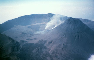
Geological Summary. The island of Fogo consists of a single massive stratovolcano that is the most prominent of the Cape Verde Islands. The roughly circular 25-km-wide island is truncated by a large 9-km-wide caldera that is breached to the east and has a headwall 1 km high. The caldera is located asymmetrically NE of the center of the island and was formed as a result of massive lateral collapse of the older Monte Armarelo edifice. A very youthful steep-sided central cone, Pico, rises more than 1 km above the caldera floor to about 100 m above the rim. Pico, which is capped by a 500-m-wide, 150-m-deep summit crater, was apparently in almost continuous activity from the time of Portuguese settlement in 1500 CE until around 1760. Later lava flows, some from vents on the caldera floor, reached the eastern coast below the breached caldera.
Information Contacts: R. Moore, U.S. Geological Survey, Mail Stop 903, Federal Center Box 25046, Denver, CO 80225 USA; Frank Trusdell, U.S. Geological Survey, Hawaiian Volcano Observatory, Hawaii National Park, HI 96718, USA; Veronica Carvalho Martins, U.S. Embassy, Rua Hoji Ya Henda 81, C.P. 201, Praia, Cape Verde; Arrigo Querido and Helena Tatiana Osorio, INGRH Servicos Estudos Hidrologicos, C.P. 367, Praia, Cape Verde; François LeGuern, CNRS Centre des Faibles Radioactivités, 91190 Gif-sur-Yvette, France; João Gaspar and Nicolau Wallenstein, Departamento Geociências, Universidad dos Açores, rue da Mae de Deus 58, 9500 Ponta Delgada, Açores, Portugal; Henry Gaudru, Christine Pittet, Patrick Barois, and Marc Sagot, Société Volcanologique Européenne (SVE), C.P. 1, 1211 Geneva 17, Switzerland; United Nations Department of Humanitarian Affairs, Palais des Nations, 1211 Geneva 10, Switzerland; International Federation of Red Cross and Red Crescent Societies, C.P. 372, 1211 Geneva 19, Switzerland.