Report on Krakatau (Indonesia) — July 1995

Bulletin of the Global Volcanism Network, vol. 20, no. 7 (July 1995)
Managing Editor: Richard Wunderman.
Krakatau (Indonesia) Unusually loud sounds shown on seismic records
Please cite this report as:
Global Volcanism Program, 1995. Report on Krakatau (Indonesia) (Wunderman, R., ed.). Bulletin of the Global Volcanism Network, 20:7. Smithsonian Institution. https://doi.org/10.5479/si.GVP.BGVN199507-262000
Krakatau
Indonesia
6.1009°S, 105.4233°E; summit elev. 285 m
All times are local (unless otherwise noted)
During June there were unofficial reports of unusually loud noises heard on the W coast of Java . . . . On 27 June, GMU scientists visited islands around Anak Krakatau and heard some very loud sounds; only some of which correlated to visual activity at Anak Krakatau. The observers compared their observations to a 1993 visit, when the volcano emitted steam-bearing discharges accompanied by lightning. The eruptions on 27 June 1995 appeared dissimilar because they were ash-rich and without visible steam. In addition, the 27 June eruptions produced string-shaped columns with mushroom-shaped tops; lightning was absent.
The group deployed two seismometers for five hours of observation. A vertical-component long-period seismometer (0.2 Hz cutoff) was put on Panjang Island, 3.6 km W of Anak Krakatau's summit, and a 3-component broadband seismometer was put on Sertung Island, 3.2 km WNW.
Typical seismograms, showing two of the three components recorded on Sertung Island, appear on figure 11. In one case, a low-frequency seismic signal arrived ~8 seconds prior to a sharp onset, reaching amplitudes of 0.6 mm/sec in the vertical component (figure 11). The second seismometer also recorded ~8 seconds of seismic signal before the onset of the air wave. Other events also showed the same 8-second delay between the seismic signal and these air waves. The case shown was correlated with a small eruption that generated a loud sound and ultimately spawned an ash cloud of undisclosed dimension. Assuming a shallow source for the eruption, the travel times for first arrivals of the strong impulsive signals across the 3.2 km source-to-receiver distance were on the order of 10 seconds, roughly the velocity of sound in air (0.33 km/sec). Thus, the strong impulsive signals were probably due to pressure waves transmitted through the air.
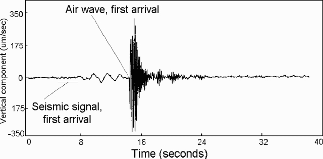 |
Figure 11. Seismic record from Anak Krakatau showing the vertical component for a typical event received on nearby Sertung Island. The data were collected on 27 June 1995 (t = 0.0 sec corresponds to 1049 local time). Approximate arrivals of the seismic and air-wave signals are indicated. Courtesy of Wahyudi and A. Brodscholl. |
Geological Summary. The renowned Krakatau (frequently mis-named as Krakatoa) volcano lies in the Sunda Strait between Java and Sumatra. Collapse of an older edifice, perhaps in 416 or 535 CE, formed a 7-km-wide caldera. Remnants of that volcano are preserved in Verlaten and Lang Islands; subsequently the Rakata, Danan, and Perbuwatan cones were formed, coalescing to create the pre-1883 Krakatau Island. Caldera collapse during the catastrophic 1883 eruption destroyed Danan and Perbuwatan, and left only a remnant of Rakata. This eruption caused more than 36,000 fatalities, most as a result of tsunamis that swept the adjacent coastlines of Sumatra and Java. Pyroclastic surges traveled 40 km across the Sunda Strait and reached the Sumatra coast. After a quiescence of less than a half century, the post-collapse cone of Anak Krakatau (Child of Krakatau) was constructed within the 1883 caldera at a point between the former Danan and Perbuwatan cones. Anak Krakatau has been the site of frequent eruptions since 1927.
Information Contacts: Wahyudi and A. Brodscholl, GMU.