Report on Melebingoy (Philippines) — September 1995
Bulletin of the Global Volcanism Network, vol. 20, no. 9 (September 1995)
Managing Editor: Richard Wunderman.
Melebingoy (Philippines) Crater lake overflow causes flooding; no volcanic activity
Please cite this report as:
Global Volcanism Program, 1995. Report on Melebingoy (Philippines) (Wunderman, R., ed.). Bulletin of the Global Volcanism Network, 20:9. Smithsonian Institution. https://doi.org/10.5479/si.GVP.BGVN199509-271011
Melebingoy
Philippines
6.113°N, 124.892°E; summit elev. 1824 m
All times are local (unless otherwise noted)
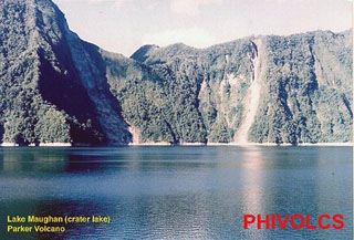
The overflow of Maughan Lake, the crater lake at Parker volcano, followed heavy rains associated with a passing typhoon and caused flashflooding in NW-flank communities on 6 September. A team from the Philippine Institute of Volcanology and Seismology (PHIVOLCS) was dispatched to determine whether the overflow was caused by volcanic activity. Although no volcanic alert was declared, PHIVOLCS recommended that the crater area should be considered off-limits because of instability of the crater walls. Fieldwork on 8-9 September revealed that the flood was channel-confined along the NW-flank Alah River, which drains the crater lake, from 1,000 m down to 540 m elevation (Barangay New Dumangas, T'boli, South Cotabato Province). Below this point it was transformed into a sheetwash. The floods killed more than 60 people, destroyed 300 homes and nine bridges, and displaced 50,000 people.
Aerial observations on 11 September indicated that two or three landslides, indicated by escarpments, had occurred along the Alah River prior to the crater lake outbreak. The total mass displaced appears to have been sufficient to have dammed the upper reaches of the river. The crater wall was well-vegetated and without landslide scars, although underwater landslides may have contributed to the rise and subsequent overflow of the lake. The overflow breached the blocked river channel, sending an estimated ~10-15 x 106 m3 of lake water down the river, lowering the lake by 1 m. No turbidity or color change was observed in the crater lake, indicating that there had been no volcanic explosion. On 9-10 September PHIVOLCS installed seismometers in T'boli, 12 km NW of the crater at 540 m elevation, and at Tobolok, ~4 km NW of the crater at 1,300 m elevation. No volcanic seismic events were recorded through 11 September.
Geological Summary. Mélébingóy (previously known as Parker) is a low, vegetated stratovolcano overlooking Sarangani Bay near the southern tip of Mindanao Island. The steep andesitic-dacitic stratovolcano is surrounded by extensive, youthful pyroclastic-flow deposits. The summit is truncated by a 2.9-km-wide caldera with steep-sided walls that rise 200-500 m above heart-shaped Maughan Lake. This volcano was the source of a major explosive eruption in 1641 CE that was previously attributed to Awu volcano on Sangihe Island. The eruption caused darkness over the island of Mindanao, deposited voluminous pyroclastic flows and lahars, and resulted in the formation of the summit caldera. This was the last of three major explosive eruptions during the previous 3,800 years.
Information Contacts: Ernesto G. Corpuz, Philippine Institute of Volcanology and Seismology (PHIVOLCS), 5th & 6th Floors Hizon Building, 29 Quezon Avenue, Quezon City, Philippines; United Press International.