Report on Ol Doinyo Lengai (Tanzania) — December 1995

Bulletin of the Global Volcanism Network, vol. 20, no. 11 (December 1995)
Managing Editor: Richard Wunderman.
Ol Doinyo Lengai (Tanzania) Minor lava flows and projectile emission in December
Please cite this report as:
Global Volcanism Program, 1995. Report on Ol Doinyo Lengai (Tanzania) (Wunderman, R., ed.). Bulletin of the Global Volcanism Network, 20:11. Smithsonian Institution. https://doi.org/10.5479/si.GVP.BGVN199512-222120
Ol Doinyo Lengai
Tanzania
2.764°S, 35.914°E; summit elev. 2962 m
All times are local (unless otherwise noted)
Summit visits by members of the Societe de Volcanologie Geneve during 15-19 December revealed low rates of intermittent effusive activity and some small explosions. Five episodes of lava emission were observed from hornito cluster T36 (BGVN20:10), each lasting
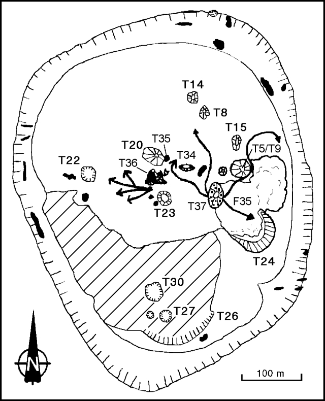 |
Figure 37. Sketch map of part of the Ol Doinyo Lengai crater showing new features and lava flows, 15-19 December 1995. Modified from the January 1994 map in BGVN 19:04. |
Almost continuous ejection of lava fragments occurred from a cinder cone T37 (~15-25 m high), and with less intensity from a hornito in a small collapse depression just W of T5/T9 (figure 37). A small lava pond, observed for ~3 hours on 16 December, inside the depression at the foot of the hornito exhibited splashing and small bubbles. Two major flank collapses of T37 released large quantities of very fast-moving (5-8 m/second) aa lava flows that were ~50 cm thick. The first flank failure, on 16 December, was a progressive event on the W side. However, the E-flank collapse on the 18th came without warning, quickly sending a lava flow NE between T5/T9 and F35, almost to the crater rim.
Fumarole temperature measurements were taken on the N crater rim, inside new cracks on the crater floor, and at the tops of T8 and T15. All temperatures were 70-80 degrees C.
Geological Summary. The symmetrical Ol Doinyo Lengai is the only volcano known to have erupted carbonatite tephras and lavas in historical time. The prominent stratovolcano, known to the Maasai as "The Mountain of God," rises abruptly above the broad plain south of Lake Natron in the Gregory Rift Valley. The cone-building stage ended about 15,000 years ago and was followed by periodic ejection of natrocarbonatitic and nephelinite tephra during the Holocene. Historical eruptions have consisted of smaller tephra ejections and emission of numerous natrocarbonatitic lava flows on the floor of the summit crater and occasionally down the upper flanks. The depth and morphology of the northern crater have changed dramatically during the course of historical eruptions, ranging from steep crater walls about 200 m deep in the mid-20th century to shallow platforms mostly filling the crater. Long-term lava effusion in the summit crater beginning in 1983 had by the turn of the century mostly filled the northern crater; by late 1998 lava had begun overflowing the crater rim.
Information Contacts: P. Vetsch, S. Haefli, and C. Peter, Societe de Volcanologie Geneve, B.P. 298, CH-1225 Chene-bourg, Switzerland.