Report on Amukta (United States) — September 1996
Bulletin of the Global Volcanism Network, vol. 21, no. 9 (September 1996)
Managing Editor: Richard Wunderman.
Amukta (United States) Small ash plumes observed in mid-September
Please cite this report as:
Global Volcanism Program, 1996. Report on Amukta (United States) (Wunderman, R., ed.). Bulletin of the Global Volcanism Network, 21:9. Smithsonian Institution. https://doi.org/10.5479/si.GVP.BGVN199609-311190
Amukta
United States
52.5°N, 171.252°W; summit elev. 1066 m
All times are local (unless otherwise noted)
On 18 September AVO received a pilot report of a small ash plume above Amukta. An Alaska Airlines pilot noted black and gray ash clouds rising ~300 m above the summit crater during overflights on 17 and 18 September. The ash plumes extended ~16 km S over the Pacific Ocean before dissipating. No plume was visible on satellite imagery.
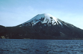
Geological Summary. The symmetrical Amukta stratovolcano lies in the central Aleutians SW of Chagulak Island and is the westernmost of the Islands of the Four Mountains group. Amukta was constructed at the northern side of an arcuate caldera-like feature that is open to the sea along the southern coast of the 8-km-wide Amukta Island. The 1066-m-high stratovolcano overlies a broad shield volcano and is topped by a 400-m-wide crater. A cinder cone is located near the NE coast. Amukta has had several eruptions in historical time from both summit and flank vents.
Information Contacts: Alaska Volcano Observatory (AVO); NOAA/NESDIS Satellite Analysis Branch, Room 401, 5200 Auth Road, Camp Springs, MD 20746, USA.