Report on Nyamulagira (DR Congo) — October 1996
Bulletin of the Global Volcanism Network, vol. 21, no. 10 (October 1996)
Managing Editor: Richard Wunderman.
Nyamulagira (DR Congo) August seismic buildup and a 1 December eruption
Please cite this report as:
Global Volcanism Program, 1996. Report on Nyamulagira (DR Congo) (Wunderman, R., ed.). Bulletin of the Global Volcanism Network, 21:10. Smithsonian Institution. https://doi.org/10.5479/si.GVP.BGVN199610-223020
Nyamulagira
DR Congo
1.408°S, 29.2°E; summit elev. 3058 m
All times are local (unless otherwise noted)
During August, Christoph Weber managed to visit Nyamuragira despite the hazard from armed groups roaming the region around the volcanoes. Although he found Nyamuragira quiet, Weber learned from Mahinda Kasereka of the Goma Volcano Observatory that seismicity had began to increase in August 1996.
An Associated Press story described lava flows escaping the crater on 1 December and reaching 10 km NW that evening. Satellite images in December as late as the 5th indicated reasonably dense plumes to ~12 km altitude. The eruption's impact on people in the region was uncertain. Further details will follow in a subsequent Bulletin.
Historical eruptions from Nyamuragira have occurred within the summit caldera and from numerous flank fissures and cinder cones. Twentieth century flank lava flows extend >30 km from the summit. In July 1994 a W-flank fissure emitted lava fountains, lava flows, and ash. For the past two and a half years this portion of Zaire's border had contained camps with hundreds of thousands of refugees; over a month ago these refugees fled to escape fighting.
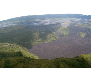
Geological Summary. Africa's most active volcano, Nyamulagira (also known as Nyamuragira), is a massive high-potassium basaltic shield about 25 km N of Lake Kivu and 13 km NNW of the steep-sided Nyiragongo volcano. The summit is truncated by a small 2 x 2.3 km caldera that has walls up to about 100 m high. Documented eruptions have occurred within the summit caldera, as well as from the numerous flank fissures and cinder cones. A lava lake in the summit crater, active since at least 1921, drained in 1938, at the time of a major flank eruption. Recent lava flows extend down the flanks more than 30 km from the summit as far as Lake Kivu; extensive lava flows from this volcano have covered 1,500 km2 of the western branch of the East African Rift.
Information Contacts: Christoph Weber, Kruppstrasse 171, 42113 Wuppertal, Germany; Wafula Mifundi and Mahinda Kasereka, Goma Volcano Observatory, Departement de Geophysique, Centre de Recherche en Sciences Naturelles, Lwiro, D.S. Bukavu, Zaire; Associated Press.

