Report on Galeras (Colombia) — September 1997

Bulletin of the Global Volcanism Network, vol. 22, no. 9 (September 1997)
Managing Editor: Richard Wunderman.
Galeras (Colombia) Low-level seismicity during May-August
Please cite this report as:
Global Volcanism Program, 1997. Report on Galeras (Colombia) (Wunderman, R., ed.). Bulletin of the Global Volcanism Network, 22:9. Smithsonian Institution. https://doi.org/10.5479/si.GVP.BGVN199709-351080
Galeras
Colombia
1.22°N, 77.37°W; summit elev. 4276 m
All times are local (unless otherwise noted)
Seismicity remained at low levels during May-August 1997. During this period 93 volcano-tectonic earthquakes were registered (figure 82) at a rate of <1 event/day, with coda magnitudes <2, except on 22 July. Although epicenters were scattered, most were located around the active crater area and N of the cone within a radius of 8 km. On 22 July an earthquake of M 3.1 was centered 8.5 km NE of the active cone at 8 km depth, over the Buesaco fault. This event was felt by the inhabitants of Pasto City and was accompanied by three aftershocks (M 2.3, 2.2, and 2.3). In addition, on 9, 20, 21, 29, and 31 July there were seismic hybrid events with high-frequency onsets and spectral contents between 1-10 Hz. The waveforms of these events were similar to spasmodic volcanic tremor; they first arrived at a station 2 km E of the main crater.
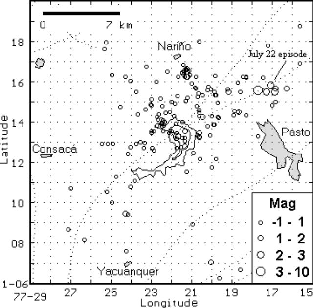 |
Figure 82. Volcano-tectonic seismicity at Galeras (center), May-August 1997. Four nearby cities are labeled. Courtesy of INGEOMINAS. |
Only 25 long-period events were registered from May to August. Some long-period events in May corresponded to monocromatic signals with a slowly decaying coda ("tornillos"), although durations were <35 seconds. Electronic tiltmeters 0.9 and 1.8 km from the active cone exhibited stability in their radial and tangential components. Peladitos-2 tiltmeter, at 1.8 km, recorded <1 µrad of change during the year. Gas emissions in the crater area seen from the observatory on 14 and 30 May and on 4 June were light in color and rose <200 m.
In July, as a complement to the cooperative program between BGR from Germany (Seminar Federal Institute for Geosciences and Natural Resources) and INGEOMINAS (Research Institute for Geosciences, Mining and Chemistry), a training course on "Geophysical Methods Applied to Volcano Monitoring" was developed. From this course two permanent telemetered seismic stations were installed 0.8 km E and 1.5 km NE from the crater. These stations are equipped with 3-component broad-band seismometers. Some aerial thermographic images obtained during the course showed hot points with surface temperatures up to 120°C.
Geological Summary. Galeras, a stratovolcano with a large breached caldera located immediately west of the city of Pasto, is one of Colombia's most frequently active volcanoes. The dominantly andesitic complex has been active for more than 1 million years, and two major caldera collapse eruptions took place during the late Pleistocene. Long-term extensive hydrothermal alteration has contributed to large-scale edifice collapse on at least three occasions, producing debris avalanches that swept to the west and left a large open caldera inside which the modern cone has been constructed. Major explosive eruptions since the mid-Holocene have produced widespread tephra deposits and pyroclastic flows that swept all but the southern flanks. A central cone slightly lower than the caldera rim has been the site of numerous small-to-moderate eruptions since the time of the Spanish conquistadors.
Information Contacts: Observatorio Vulcanologico y Sismologico de Pasto, INGEOMINAS, Carrera 31, No. 18-07 Parque Infantil, PO Box 1795, Pasto, Colombia (URL: http://mafalda.univalle.edu.co/~ovp).