Report on Piton de la Fournaise (France) — February 1998

Bulletin of the Global Volcanism Network, vol. 23, no. 2 (February 1998)
Managing Editor: Richard Wunderman.
Piton de la Fournaise (France) First eruption in over 5 years begins 9 March
Please cite this report as:
Global Volcanism Program, 1998. Report on Piton de la Fournaise (France) (Wunderman, R., ed.). Bulletin of the Global Volcanism Network, 23:2. Smithsonian Institution. https://doi.org/10.5479/si.GVP.BGVN199802-233020
Piton de la Fournaise
France
21.244°S, 55.708°E; summit elev. 2632 m
All times are local (unless otherwise noted)
Piton de la Fournaise began erupting 9 March at 1500 preceded by a number of earthquakes and strong deformations. The volcano had been quiet since the last fissure eruption on 27 August 1992. The Volcanological Observatory of Piton de la Fournaise (OVPDLF) was able to give authorities two days warning of the impending crisis. Thomas Staudacher, director of OVPDLF, deployed additional seismic and deformation monitoring equipment in the early stages of the event.
Eruptions first started from a fissure at 2,450 m on the N flank of the terminal Dolomieu crater, a spot in the interior of l'Enclos Fouqu' caldera (figure 40). Venting quickly migrated northward to lower altitudes (1,950 m). The activity was focused at two fissures near the very bottom of the slope of Dolomieu and cones were forming at the place where lava fountains were most active.
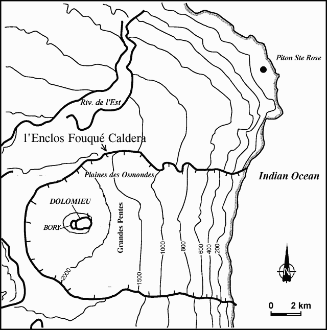 |
Figure 40. Sketch map of Piton de la Fournaise and vicinity. Notice that the topographic contour intervals are uneven. Courtesy of OVPDLF. |
The lava fountains, some reaching 50 m in height, fed a voluminous flow that progressed N and E towards the Indian Ocean. Lava issued in a sustained flow rate estimated at 20 m3/s; the total volume since the start of the eruption was estimated on 10 March at 7 x 10⁶ m3. The zone where the lava was flowing, to the NE along Osmondes plain in the direction of the sea, is wholly uninhabited. By 10 March activity appeared to be weakening, the front of the flow moving more slowly towards Grandes Pentes. Mist and haze over the Osmondes plain on 11 March prevented observation of the advance of the flow.
Seismicity had increased since the beginning of 1998. Volcanic tremor accompanied venting, including an almost continuous seismic swarm (30 earthquakes per hour in the hours preceding the eruption) beneath the summit's Bory crater in the SW. In the hour before magma venting, inclinometers in the summit area indicated the injection of a dyke and then the opening of a surface fissure. Tremors and swarm were accompanied by intermittent earthquakes, discrete events not usually seen in Piton's past eruptions.
By 1600 on 11 March, cones of scoria had attained heights of 10 m on Piton's upper slopes and 30 m on its lower slopes and were being fed by lava fountains nearly 30 m high. On 12 March at about 0245, a new but much less productive eruptive fissure opened on the opposite (SW) side of the terminal cone at 2,250 m elevation.
A "level one" volcano alert was issued 9 March at 0500 by island prefect Robert Pommies following heavy seismic activity during the weekend. The alert was reduced to "level two" after it was seen that the lava eruption was centered on the N of the volcano. Agence France Presse reported that there was no threat to the village of Sainte-Rose, which had to be evacuated in 1978.
A 14-16 March report stated that eruptive activity at both fissures (N and SW of the central cone) continued uninterrupted through 12 March. Emissions at the N fissures focused on the central vents and built cones ~50 m high. The output rate was ~15-30 m3/s and the lava flow front was stationary (4 km E at ~1,100 m elevation) with a maximum lava temperature of 1,167°C. Also, venting on the SW fissure centered on a limited stretch and built a spatter rampart ~70 m long. The output rate was ~5-10 m3/s with a maximum temperature of ~1,135°C. The latter activity gave rise to a 1.5 km flow. The discrete seismic events that were observed over the continuous tremor had ceased since 12 March but a single event was observed in the night of 13-14 March.
Geological Summary. Piton de la Fournaise is a massive basaltic shield volcano on the French island of Réunion in the western Indian Ocean. Much of its more than 530,000-year history overlapped with eruptions of the deeply dissected Piton des Neiges shield volcano to the NW. Three scarps formed at about 250,000, 65,000, and less than 5,000 years ago by progressive eastward slumping, leaving caldera-sized embayments open to the E and SE. Numerous pyroclastic cones are present on the floor of the scarps and their outer flanks. Most recorded eruptions have originated from the summit and flanks of Dolomieu, a 400-m-high lava shield that has grown within the youngest scarp, which is about 9 km wide and about 13 km from the western wall to the ocean on the E side. More than 150 eruptions, most of which have produced fluid basaltic lava flows, have occurred since the 17th century. Only six eruptions, in 1708, 1774, 1776, 1800, 1977, and 1986, have originated from fissures outside the scarps.
Information Contacts: Thomas Staudacher, Director, Observatoire Volcanologique du Piton de la Fournaise (OVPDLF), 14 RN3, le 27Km, 97418 La Plaine des Cafres, La Réunion, France (URL: http://www.ipgp.jussieu.fr/); Agence France Presse, Paris, France.