Report on Turrialba (Costa Rica) — March 1998

Bulletin of the Global Volcanism Network, vol. 23, no. 3 (March 1998)
Managing Editor: Richard Wunderman.
Turrialba (Costa Rica) Fumarolic condensate data and monthly earthquakes to March 1998
Please cite this report as:
Global Volcanism Program, 1998. Report on Turrialba (Costa Rica) (Wunderman, R., ed.). Bulletin of the Global Volcanism Network, 23:3. Smithsonian Institution. https://doi.org/10.5479/si.GVP.BGVN199803-345070
Turrialba
Costa Rica
10.025°N, 83.767°W; summit elev. 3340 m
All times are local (unless otherwise noted)
OVSICORI-UNA scientists have taken sporadic samples of the chemistry, pH, and temperature of Turrialba's fumaroles (figures 2 and 3). During January, fumaroles had low emissions but the temperature of one fumarole remained fixed at 90°C (figure 3). Small landslides down the N and S sides of the crater walls covered fumaroles on the crater floor during January; however, during this time new fumaroles also appeared on the crater floor as well.
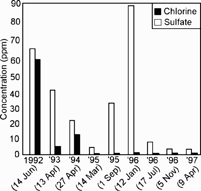 |
Figure 2. Chlorine and sulfate in Turrialba fumarolic condensate at [nine] sampling dates during late 1996-early [1997]. For sampling and analytical methods, contact the authors. Courtesy of OVSICORI-UNA. |
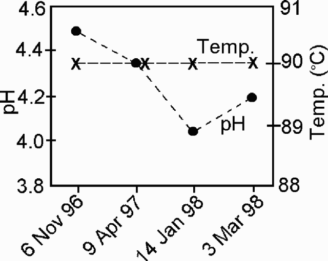 |
Figure 3. The pH and temperature of Turrialba fumarolic condensate at four sampling dates during the interval late 1996 to early 1998. Courtesy of OVSICORI-UNA. |
The local seismic station ("VTU," located 500 m S of the active crater) was out of service during September-December 1997. After that, the station registered microearthquakes as follows: January, 53; February, 83; and March 96. Two of the February earthquakes, one high- and one low-frequency, also registered on the more distant seismic station IRZ2, ~15 km from the active crater. Besides the 96 microearthquakes registered during March, several more low- and high-frequency earthquakes also took place.
Geological Summary. Turrialba, the easternmost of Costa Rica's Holocene volcanoes, is a large vegetated basaltic-to-dacitic stratovolcano located across a broad saddle NE of Irazú volcano overlooking the city of Cartago. The massive edifice covers an area of 500 km2. Three well-defined craters occur at the upper SW end of a broad 800 x 2200 m summit depression that is breached to the NE. Most activity originated from the summit vent complex, but two pyroclastic cones are located on the SW flank. Five major explosive eruptions have occurred during the past 3500 years. A series of explosive eruptions during the 19th century were sometimes accompanied by pyroclastic flows. Fumarolic activity continues at the central and SW summit craters.
Information Contacts: E. Fernandez, V. Barboza, R. Van der Laat, R. Saenz, E. Duarte, E. Malavassi, T. Marino, M. Martinez, and E. Hernandez, Observatorio Vulcanologico y Sismologico de Costa Rica, Universidad Nacional (OVSICORI-UNA), Apartado 86-3000, Heredia, Costa Rica; Mauricio Mora Fernandez, Sección de Sismologia, Vulcanologia y Exploración Geofisica, Escuela Centroamericana de Geología, Universidad de Costa Rica, P.O. Box 35-2060, San José, Costa Rica.