Report on Galeras (Colombia) — May 1998

Bulletin of the Global Volcanism Network, vol. 23, no. 5 (May 1998)
Managing Editor: Richard Wunderman.
Galeras (Colombia) Continuing seismicity includes tornillo events
Please cite this report as:
Global Volcanism Program, 1998. Report on Galeras (Colombia) (Wunderman, R., ed.). Bulletin of the Global Volcanism Network, 23:5. Smithsonian Institution. https://doi.org/10.5479/si.GVP.BGVN199805-351080
Galeras
Colombia
1.22°N, 77.37°W; summit elev. 4276 m
All times are local (unless otherwise noted)
Seismicity continued at low levels around Galeras during March and April. Over this period 92 volcano-tectonic (VT) earthquakes were located; of these, 53 were in the area called the North Source (dashed box in figure 88). On 16 March at 2124 (GMT) a VT event with a coda magnitude of 2.2 was felt in Pasto City and other towns in the area. The event was centered in the North Source 2 km N of the crater at a depth of 5 km below the summit. The most energetic VT event outside of the North Source occurred on 29 April. That event struck SW of the crater with a coda magnitude of 2.1 and a depth of 6.5 km.
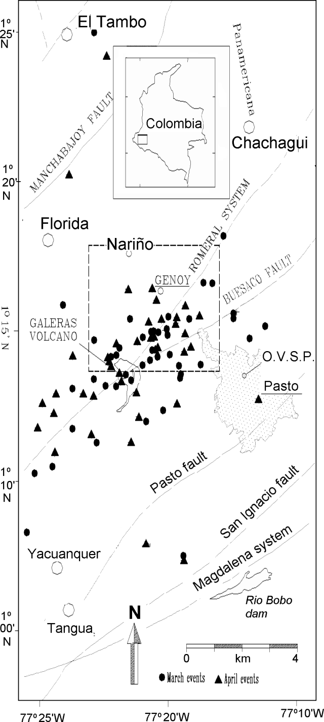 |
Figure 88. Epicenters of volcano-tectonic earthquakes surrounding Galeras that took place during March -April 1998. The North Source is outlined by the dashed box. Courtesy OVP-INGEOMINAS. |
Another aspect of seismicity during March and April was the continuation of Long Period (LP) events called Tornillos. Tornillo events characteristically have quasi-monochromatic wave-forms with slowly decaying coda values and hence leave a seismic record that looks like the threads of a screw. A record 38 such events have been recorded since November 1997 (BGVN 22:09 and 22:12). The last Tornillo was recorded 10 April.
On 19 April an event similar to spasmodic tremor was recorded. The cause was mud flow along the Azufral River, which runs west from the summit, resulting from heavy rain on volcanic deposits. The event lasted for about 1 hour.
Two electronic tiltmeters, located at the summit and on the E flank (figure 89), remained stable with minimum fluctuations during the period. Fumarole temperature, hot springs pH, radon, and gas-emission measurements showed no significant changes with respect to previous months. The Galeras Seismological Network monitors the volcano with five short-period and two broad-band telemeters, which are part of a cooperative project between OVP-INGEOMINAS (see below) and the German Federal Institute for Geosciences and Natural Resources.
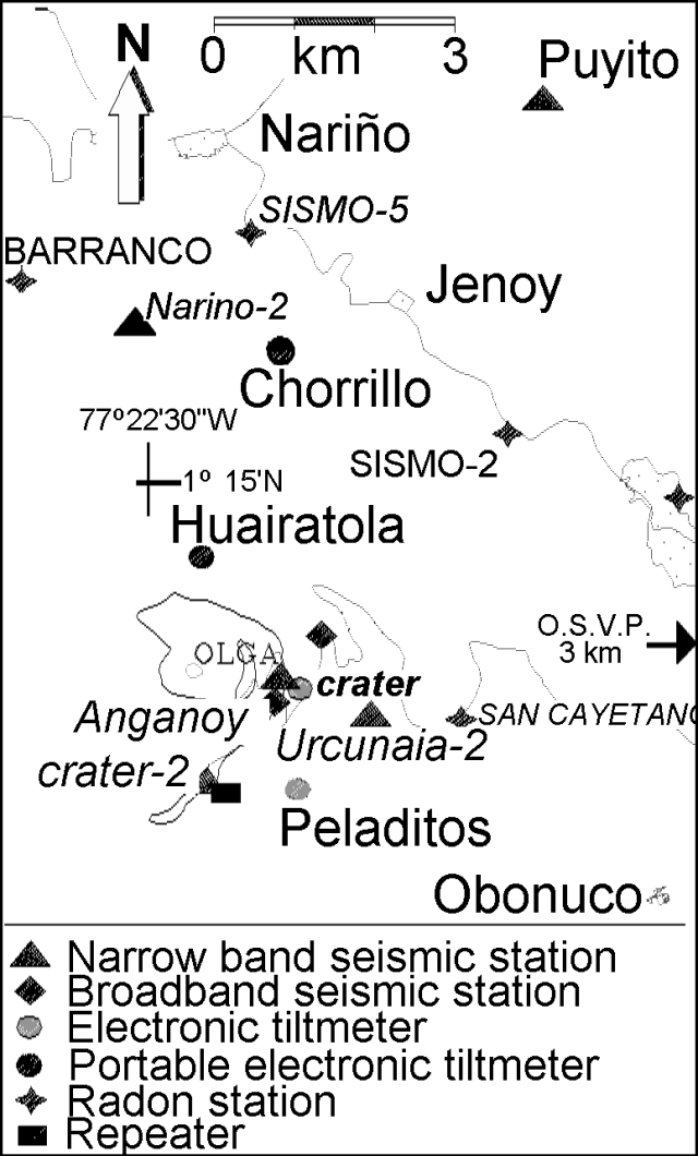 |
Figure 89. Galeras Volcano Vilgilance Network: monitoring equipment within 5 km of the summit. Courtesy OVP-INGEOMINAS. |
Geological Summary. Galeras, a stratovolcano with a large breached caldera located immediately west of the city of Pasto, is one of Colombia's most frequently active volcanoes. The dominantly andesitic complex has been active for more than 1 million years, and two major caldera collapse eruptions took place during the late Pleistocene. Long-term extensive hydrothermal alteration has contributed to large-scale edifice collapse on at least three occasions, producing debris avalanches that swept to the west and left a large open caldera inside which the modern cone has been constructed. Major explosive eruptions since the mid-Holocene have produced widespread tephra deposits and pyroclastic flows that swept all but the southern flanks. A central cone slightly lower than the caldera rim has been the site of numerous small-to-moderate eruptions since the time of the Spanish conquistadors.
Information Contacts: Pablo Chamorro and Diego Gomez Martinez, Observatorio Vulcanologico y Sismologico de Pasto (OVP), INGEOMINAS, Carrera 31, No. 18-07 Parque Infantil, PO Box 1795, Pasto, Colombia (URL: https://www2.sgc.gov.co/volcanes/index.html).