Report on Kilauea (United States) — August 1998

Bulletin of the Global Volcanism Network, vol. 23, no. 8 (August 1998)
Managing Editor: Richard Wunderman.
Kilauea (United States) Eruptive pause (No. 20) followed by a new pahoehoe flow to the sea
Please cite this report as:
Global Volcanism Program, 1998. Report on Kilauea (United States) (Wunderman, R., ed.). Bulletin of the Global Volcanism Network, 23:8. Smithsonian Institution. https://doi.org/10.5479/si.GVP.BGVN199808-332010
Kilauea
United States
19.421°N, 155.287°W; summit elev. 1222 m
All times are local (unless otherwise noted)
Lava continued erupting from vents on the SW of Pu`u `O`o and traveling 12 km to the coast through lava tubes. Following a pause in the magma supply on 12-14 August, lava escaping from the tubes resulted in a new pahoehoe flow at the base of the fault scarp (pali), but a new lava tube eventually developed within the flow. The flow front reached the sea on 30 August, entering ~400 m W of the long-established Kamokuna entry.
Above the shoreline, spreading lava formed small pahoehoe toes along its margins. The new flow was extremely hot and made the approach from the W difficult and hazardous. Lava at the new entry initially poured over a sea cliff (created by previous bench collapses) onto a black-sand beach. Material arriving at both new and old entry points added to the Kamokuna bench.
Twenty pauses, lasting from a few hours to a few days, have occurred since Episode 55 began in March 1997. These short-term interruptions in magma supply to Pu`u `O`o result from blockages in the conduit system between the summit magma reservoir and Pu`u `O`o. The most recent pause (No. 20) began on 12 August and lasted approximately 42 hours, during which time Kīlauea's summit inflated ~2 µrad. The slight inflation indicated magma was still rising into the summit but not moving to the rift zone.
When lava reemerged from Pu`u `O`o and again flowed through the tubes, several flows broke out on the pali and at its base (figure 122). The largest flow originated from the same breakout point that was active following a pause in July (BGVN 23:06). Daily lava-discharge rates from Pu`u `O`o remained little changed; surveys made during the last few weeks of August indicated that ~250,000 m3 of lava per day traveled through the tube. Since March 1998, the average daily lava discharge was ~300,000 m3.
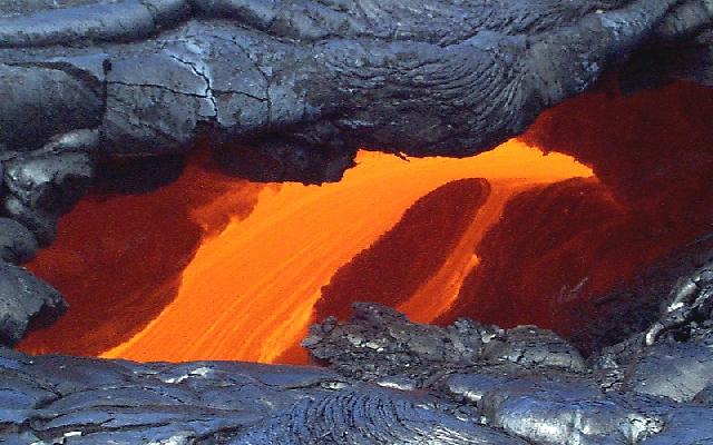 |
Figure 122. Close-up view of Kīlauea lava flowing through a new shallow lava tube that developed in lava-flow breakouts following pause No. 20 of Episode 55, mid-August 1998. Lava from this tube fed the new pahoehoe flow. Courtesy of HVO. |
Seismologists noted a series of more than two dozen seismic signals at Pu`u `O`o on 26 August. The signals had a frequency lower than is typical of most earthquakes, and were likely caused by the partial collapse of a spatter cone on the W flank of Pu`u `O`o (figure 123). By 3 September the the spatter cone crater had grown to ~50 m in diameter.
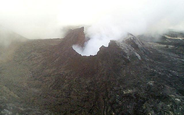 |
Figure 123. Aerial view of Kīlauea on 27 August 1998 showing the Episode 55 spatter cone located on the W of Pu`u `O`o. The low notch is the missing part of the cone, which probably collapsed the day before the photo was taken. Courtesy of HVO. |
Geological Summary. Kilauea overlaps the E flank of the massive Mauna Loa shield volcano in the island of Hawaii. Eruptions are prominent in Polynesian legends; written documentation since 1820 records frequent summit and flank lava flow eruptions interspersed with periods of long-term lava lake activity at Halemaumau crater in the summit caldera until 1924. The 3 x 5 km caldera was formed in several stages about 1,500 years ago and during the 18th century; eruptions have also originated from the lengthy East and Southwest rift zones, which extend to the ocean in both directions. About 90% of the surface of the basaltic shield volcano is formed of lava flows less than about 1,100 years old; 70% of the surface is younger than 600 years. The long-term eruption from the East rift zone between 1983 and 2018 produced lava flows covering more than 100 km2, destroyed hundreds of houses, and added new coastline.
Information Contacts: Hawaiian Volcano Observatory (HVO), U.S. Geological Survey, PO Box 51, Hawaii Volcanoes National Park, HI 96718, USA (URL: https://volcanoes.usgs.gov/observatories/hvo/); Ken Rubin and Mike Garcia, Hawaii Center for Volcanology, University of Hawaii, Dept. of Geology & Geophysics, 2525 Correa Rd., Honolulu, HI 96822 USA (URL: http://www.soest.hawaii.edu/GG/hcv.html).