Report on Soufriere Hills (United Kingdom) — September 1998

Bulletin of the Global Volcanism Network, vol. 23, no. 9 (September 1998)
Managing Editor: Richard Wunderman.
Soufriere Hills (United Kingdom) Continuing decrease in activity; hazards reassessed
Please cite this report as:
Global Volcanism Program, 1998. Report on Soufriere Hills (United Kingdom) (Wunderman, R., ed.). Bulletin of the Global Volcanism Network, 23:9. Smithsonian Institution. https://doi.org/10.5479/si.GVP.BGVN199809-360050
Soufriere Hills
United Kingdom
16.72°N, 62.18°W; summit elev. 915 m
All times are local (unless otherwise noted)
The following summarizes the Montserrat Volcano Observatory's (MVO) scientific reports for July and August, except information concerning the 3 July pyroclastic flows, which was reported in BGVN 23:07.
Summary. In the weeks following the 3 July pyroclastic flows, no fresh magma reached the surface; however, vesicular ballistic blocks were recovered from craters on Perches Mountain suggesting that there may have been a small Vulcanian explosion. SO2-flux levels declined steadily throughout July to an average of 1,000 metric tons/day (t/d). Vigorous steam-and-ash venting continued from the dome-collapse scar until the end of July. Activity in August was dominated by several small dome-collapse events and a period of enhanced steam-and-ash venting in the middle of the month. The dome-collapse events were caused by the gravitational collapse of weakened dome rock. The ash venting was intense one day but waned over following days to normal levels. MiniCOSPEC results showed a peak that coincided with the enhanced venting, but there was an overall decline from ~1,000 t/d at the beginning of the month to ~500 t/d at the end of the month.
Visual observations. Ash-and-steam venting immediately after the 3 July event was vigorous. Significant pulses of steam-and-ash continued for 2-3 weeks and fumarolic activity was evident on the S and N flanks of the dome.
A steep buttress overhanging the 3 July scar collapsed on 16 August generating pyroclastic flows that reached the Tar River delta. Large fragments of the buttress were left in the area of the scar's mouth. On 19 August fumarolic activity in the scar increased in intensity: fumaroles on the back wall and at the base of the scar discharged copious quantities of steam and ash in jets. The next day activity decreased in intensity and the fumaroles were generally issuing steam only. Some of the fumaroles were temporarily buried following a rockfall within the scar on 20 August. The fumarolic activity declined steadily, and by 22 August activity had declined to levels observed in the first week of August.
Mudflows continued to be a problem in July. Mudflow deposits built up beneath the Belham Bridge until there was a clearance of only about 30 cm.
Seismicity. After 5 July, seismicity returned to levels similar to the previous month, with the exception of a swarm of volcano-tectonic earthquakes on 25 July (figure 43). This swarm had no outward manifestation at the volcano and activity returned to low levels by the next day.
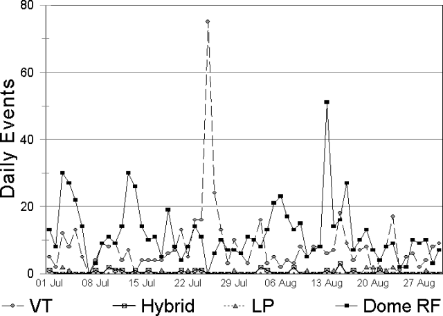 |
Figure 43. Seismicity recorded at Soufriere Hills by type during July and August 1998. Data courtesy of MVO. |
Seismicity during August was generally low. Activity was dominated by small volcano-tectonic earthquakes located ~3 km below the dome, with occasional rockfalls and pyroclastic-flow signals. On 13 August there were two episodes (at 0519 and 1455) of pyroclastic flow in the White River valley. These flows traveled 1.8 km from the dome and were caused by the collapse of weakened dome rock. Active fumaroles on the Galways side of the dome near Chances Peak undermined part of the dome. A scar immediately above the fumarolic area is believed to be the source of the pyroclastic flows. Each episode was followed by about an hour of continuous rockfall activity. On 19 August a rockfall signal was followed by tremor, which corresponded to vigorous ash venting. The signal lasted two days and varied in amplitude. At times of highest amplitude the tremor was nearly monochromatic at 4 Hz.
Ground deformation. Measurements from GPS survey sites on the flanks of the volcano and in the N of the island indicated widespread major reductions in movement during July. The Hermitage site indicated continued slow movement NE at rate of ~0.5 cm/month. The GPS site at Perches was destroyed in the 3 July event; ballistics were scattered over Perches Mountain and the GPS site was later found at the edge of a 3.4 m diameter impact crater. The rates of movement of sites in August were within the instrumental error. The GPS kit was used for one week by volcanologists from the University of Rhode Island who were conducting a bathymetric survey of the fans at the mouths of the Tar River and White Rivers valleys.
The EDM reflector on Peak B was measured from Windy Hill. The increase in distance of 5 cm during the period May-July may have been caused partially by release associated with the 3 July collapse. The line had shortened by 9 cm between 25 January and 13 May, but between May and August the distance lengthened by a total 8 cm (within 1 cm of its original length) possibly indicating a relaxation in the confining pressure.
Volume measurements. A kinematic GPS survey of the Tar River fan was completed in July. The total volume of the fan was estimated to be 22.1 x 10⁶ m3. A previous survey in August 1997 gave a volume of 15.7 x 10⁶ m3. Much of the increase resulted from the 3 July collapse, which extended the fan 350 m N, although a small part of the increase was due to the accumulation of pyroclastic-flow deposits during the September-October 1997 explosion sequence (BGVN 22:10 and 22:11). The E limit of the fan, defined by a steep shelf extending into the sea, was unchanged. A small deposit was left on the S side of the fan, although above the established shoreline there was only a thin layer of pyroclastic-flow deposits.
No volume measurements were made in August. Attempts to survey the 3 July collapse scar were foiled by deteriorating weather conditions and a lack of helicopter fuel.
Environmental monitoring. MiniCOSPEC observations recommenced on 5 July. In early July SO2 flux was generally between 1,000 and 2,500 metric tons/day (t/d). On 13 July SO2 flux measured 4,150 t/d, the highest ever recorded at Montserrat. Throughout the remainder of July there was a gradual decline in SO2 flux to an average of 1,000 t/d at the end of the month. The cause of the relatively high gas flux in the apparent absence of magmatic activity was being investigated, but may relate to perturbations in the hydrothermal system caused by the dome collapse on 3 July 1998.
MiniCOSPEC measurements in early August showed a consistent SO2 flux of ~500-1000 t/d. On 19 August levels rose to 1,400 t/d as a result of enhanced venting. Towards the end of the month poor weather limited the number of COSPEC measurements, but there appeared to be a slight decrease to an average of ~500 t/d. Throughout late August the wind direction was variable due to tropical storms in the area. On occasions when the wind blew to the N or NW a strong smell of sulfurous gases was detected in the inhabited area of Montserrat.
Sulfur dioxide diffusion tubes exposed between 29 June and 13 July clearly reflect the high emissions in early July (table 31). The Plymouth area in particular was subjected to very high concentrations of gas. In the second half of July SO2 concentrations in Plymouth were reduced by half. Populated areas N of the Belham River valley were, as usual, only subjected to very low SO2 levels in July. In August there was a general decline of SO2 in the atmosphere. An additional monitoring site in the N of the island was installed to assess SO2 during shifts in wind direction.
Table 31. Sulfur dioxide diffusion-tube results, 29 June-11 August 1998. Levels are in parts per billion (ppb). Courtesy of MVO.
| Station | 29 Jun-13 Jul 1998 | 13 Jul-27 Jul 1998 | 27 Jul-11 Aug 1998 |
| Police HQ, Plymouth | 207.9 | 116.5 | 131.5 |
| St. George's Hill | 22.05 | 8.55 | 9.55 |
| Weekes | 5.75 | 4.1 | 2.85 |
| MVO south | 4.3 | 3.85 | -- |
| Lawyers | 2.2 | 0 | 3.8 |
| Vue Pointe Hotel | -- | -- | 3.25 |
Hazard assessment. A meeting was held 14-16 July at McChesney's Estate to assess the current hazards and risks associated with Soufriere Hills Volcano. The meeting brought together many of the senior scientists who have worked at MVO during the three-year volcanic crisis. Those who took part were Richie Robertson, Lloyd Lynch and John Shepherd from the Seismic Research Unit in Trinidad; Simon Young, Sue Loughlin, Tony Reedman, and Gill Norton from the British Geological Survey; and many other senior scientists from around the world including Steve Sparks from Bristol University, Peter Baxter from Cambridge University, Barry Voight from Penn State University, Joe Devine from Brown University, Peter Francis from the Open University, Keith Rowley, and Willy Aspinall. Richard Luckett and Richard Herd from MVO provided up-to-date information about the current status of Soufriere Hills volcano.
Discussion was held on various aspects of the activity over the previous six months, including the event on 3 July. Related issues, including the safety of Bramble airport, were also addressed. An assessment of the level of risk associated with the volcano was undertaken. A report was presented to the government of Montserrat and the U.K. on 29 July after which the findings were made public.
According to the report, MVO judged it likely that the volcano has entered a period of repose, with the probability of no further magmatic eruptions in the next 6 months set at about 95%. MVO was confident that renewed magma ascent and escalation to dangerous levels of activity could be identified, although they cautioned that escalation might take place in a very short period of time (e.g. a matter of hours). Most of the island was perceived to be under reduced risk, but areas S of the Belham River Valley remain vulnerable to serious volcanic hazards including pyroclastic flows related to the collapse of the dome, mud flows, and exposure to fine ash. Further dome collapses were deemed likely and could affect all flanks of the volcano, especially the Tar River, Gages Valley, Plymouth area, Galways, and the NE slopes. There is potential for a variety of events to take place, including steam explosions, mud flows, and ash falls, for many years to come but the risks will decline with time. Health risk analysis showed that if magmatic activity does not resume, the potential for harmful exposure to ash will be limited and the risk of developing silicosis will be low in Zones 1 to 3. The same would apply to Population Zone 4 north of the Belham Valley after a clean-up operation has been safely completed. A public education program on the health risks of ash was recommended, including guidance on protection measures during the clean up. Certain groups could be at risk from much higher exposure (e.g. outdoor workers and asthma sufferers) and there may be unknown long-term health risks to young children.
The Volcanic Executive Group (VEG), chaired by Governor Tony Abbott, met to consider the Scientific Review. A statement from the Governor's Office following the meeting rescinded the recommendation that residents leave the Central Zone. Also, there was no longer any objection to commercial organizations operating within the Central Zone. The clean up of Friths, Salem, and Old Towne, which commenced some weeks ago, was intensified. The VEG sought advice on how to ensure that the Zone will be cleaned so that children and those with respiratory problems will not be affected on reoccupation.
Geological Summary. The complex, dominantly andesitic Soufrière Hills volcano occupies the southern half of the island of Montserrat. The summit area consists primarily of a series of lava domes emplaced along an ESE-trending zone. The volcano is flanked by Pleistocene complexes to the north and south. English's Crater, a 1-km-wide crater breached widely to the east by edifice collapse, was formed about 2000 years ago as a result of the youngest of several collapse events producing submarine debris-avalanche deposits. Block-and-ash flow and surge deposits associated with dome growth predominate in flank deposits, including those from an eruption that likely preceded the 1632 CE settlement of the island, allowing cultivation on recently devegetated land to near the summit. Non-eruptive seismic swarms occurred at 30-year intervals in the 20th century, but no historical eruptions were recorded until 1995. Long-term small-to-moderate ash eruptions beginning in that year were later accompanied by lava-dome growth and pyroclastic flows that forced evacuation of the southern half of the island and ultimately destroyed the capital city of Plymouth, causing major social and economic disruption.
Information Contacts: Montserrat Volcano Observatory (MVO), c/o Chief Minister's Office, PO Box 292, Plymouth, Montserrat, West Indies (URL: http://www.mvo.ms/); Richard Aspin, Information & Education Unit, Emergency Dept., St Johns Village, Montserrat, Leeward Islands, West Indies.