Report on Nyamulagira (DR Congo) — October 1998

Bulletin of the Global Volcanism Network, vol. 23, no. 10 (October 1998)
Managing Editor: Richard Wunderman.
Nyamulagira (DR Congo) Flank lava flow in October; TOMS data
Please cite this report as:
Global Volcanism Program, 1998. Report on Nyamulagira (DR Congo) (Wunderman, R., ed.). Bulletin of the Global Volcanism Network, 23:10. Smithsonian Institution. https://doi.org/10.5479/si.GVP.BGVN199810-223020
Nyamulagira
DR Congo
1.408°S, 29.2°E; summit elev. 3058 m
All times are local (unless otherwise noted)
Eruptive activity occurred at Nyamuragira volcano beginning on 17 October. During the following week several Strombolian explosions and effusive activity were reported. Lava "gently gushed" from the cone and through a fissure in its side, according to an official at the National Scientific Research Centre (CNRS) quoted in a Reuters news report. On 19 October the central crater opened and the lava flowed into the surrounding forest. Glow was visible at night from the city of Goma, ~30 km SE of the volcano. The flows were still active but diminishing at the time of the last report on 25 October. Scientists are not able to visit the site because of the threat of civil unrest. Virunga National Park has been closed for months.
An SO2 plume was first detected by the Earth Probe Total Ozone Mapping Spectrometer (TOMS) on 18 October. Although the image resolution is not sufficient to differentiate between Nyamuragira and Nyiragongo as a plume source, the former has previously emitted large amounts of sulfur dioxide. Imagery the next day (figures 16 and 17) showed that the plume extended ~700 km SW from the volcano and covered an area of 300,000 km2. Scientists at the Goddard Space Flight Center calculated that this plume contained 115 kilotons (kt) of SO2. An SO2 plume was detected on each day from 18 through 29 October. On 29 October the plume was directed to the N and contained 10 kt of SO2. No SO2 was detected in images taken from 30 October through 4 November. Visible satellite imagery acquired by the Toulouse Volcanic Ash Advisory Center on 20 October did not show any evidence of an ash plume, but convective clouds were obscuring the area.
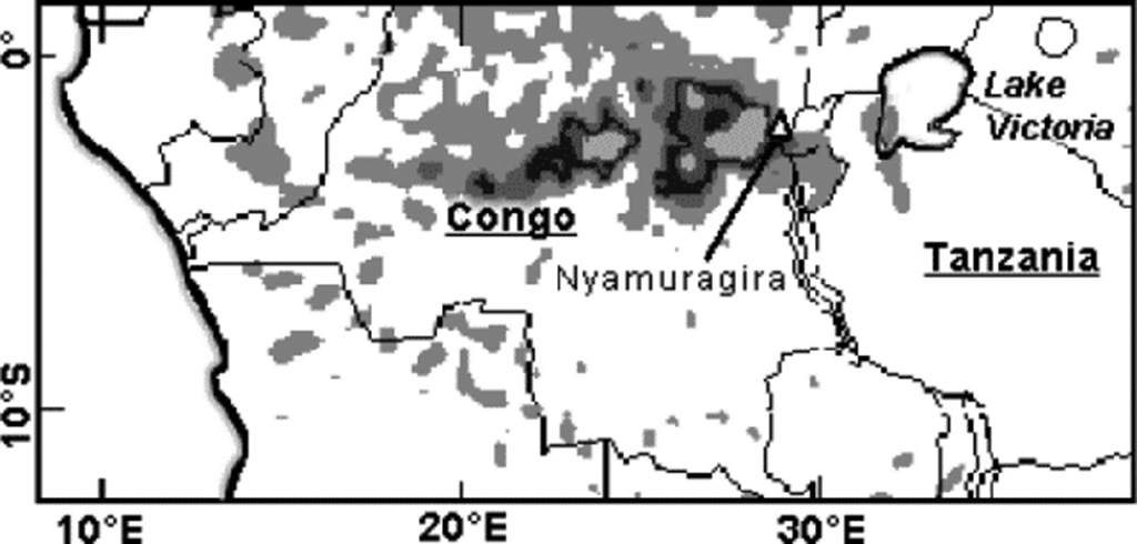 |
Figure 16. Detail of Total Ozone Mapping Spectrometer (TOMS) satellite image of the SO2 plume over Nyamuragira on 19 October 1998. Darker areas represent higher concentrations; those areas contained within black represent higher concentrations than the black areas. Courtesy of George Stephens and Robert Farquhar, NOAA/NESDIS. |
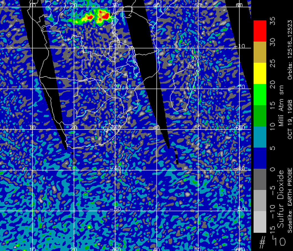 |
Figure 17. Color Total Ozone Mapping Spectrometer (TOMS) satellite image of the SO2 plume over Nyamuragira on 19 October 1998. Red areas represent higher concentrations. Courtesy of George Stephens and Robert Farquhar, NOAA/NESDIS. |
Geological Summary. Africa's most active volcano, Nyamulagira (also known as Nyamuragira), is a massive high-potassium basaltic shield about 25 km N of Lake Kivu and 13 km NNW of the steep-sided Nyiragongo volcano. The summit is truncated by a small 2 x 2.3 km caldera that has walls up to about 100 m high. Documented eruptions have occurred within the summit caldera, as well as from the numerous flank fissures and cinder cones. A lava lake in the summit crater, active since at least 1921, drained in 1938, at the time of a major flank eruption. Recent lava flows extend down the flanks more than 30 km from the summit as far as Lake Kivu; extensive lava flows from this volcano have covered 1,500 km2 of the western branch of the East African Rift.
Information Contacts: C. Akumbi, Goma Volcano Observatory, Departement de Geophysique, Centre de Recherche en Sciences Naturelles, Lwiro, D.S. Bukavu, DR Congo; Stephen J. Schaefer, Joint Center for Earth System Technology (NASA-UMBC), Mail Code 921, NASA Goddard Space Flight Center, Greenbelt, MD 20771 USA; George Stephens, NOAA/NESDIS, E/SP22, 5200 Auth Road, Camp Springs, MD 20746-4304, USA; Robert D. Farquhar, NOAA/NESDIS, FB-4, Suitland, MD 20233-9909 USA; Volcanic Ash Advisory Center (VAAC) Toulouse, Météo-France, 42 Avenue Gaspard Coriolis, F-31057 Toulouse cedex, France; Reuters Limited.