Report on Krakatau (Indonesia) — January 2001
Bulletin of the Global Volcanism Network, vol. 26, no. 1 (January 2001)
Managing Editor: Richard Wunderman.
Krakatau (Indonesia) Eruptive activity through late October 2000; infrasonic earthquakes detected
Please cite this report as:
Global Volcanism Program, 2001. Report on Krakatau (Indonesia) (Wunderman, R., ed.). Bulletin of the Global Volcanism Network, 26:1. Smithsonian Institution. https://doi.org/10.5479/si.GVP.BGVN200101-262000
Krakatau
Indonesia
6.1009°S, 105.4233°E; summit elev. 285 m
All times are local (unless otherwise noted)
Krakatau activity continued after the previous report (BGVN 25:05) through October 2000 although intensity decreased relative to the 29 May 2000 eruption. The volcano's hazard status, however, did not exceed 2 (on a scale of 1-4) within the report period. During 27 June-2 July explosions sent ash to heights up to 500 m, and booming sounds could be heard on three occasions. VSI reports resumed as of 25-30 July when seismographs recorded 1,961 explosion earthquakes, compared to 441 about a month earlier. An infrasonic sensor detected 37 events. A volcanic ash advisory was issued based on a pilot report of ash observed at an altitude of ~6,100 m. Satellite imagery did not detect a significant plume on this date, and no additional ash advisories were dispatched.
Activity remained similar through 15-21 August. Frequent booming was heard, and high numbers of explosion and infrasonic earthquakes were detected. A volcanic ash advisory was issued on 20 August although it indicated that plumes were sparse, did not reach high altitudes, and dissipated quickly. During 22 August-4 September a white, low-density plume rose 50 m above the summit. No visual observations could be made due to heavy fog, clouds, or smog masking the summit from view during 5 September-30 October, although seismicity indicated persistent activity. During 5-18 September, 3,220 explosions and 17 infrasonic events were recorded. Audible booming, however, ceased on 12 September, and activity decreased dramatically through the end of October. Deep volcanic (A-type) earthquakes stopped occurring as of 10 October, although a low number of small explosion earthquakes and tectonic earthquakes continued through 30 October. No further VSI reports were issued for Krakatau in 2000.
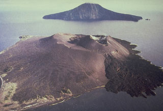
Geological Summary. The renowned Krakatau (frequently mis-named as Krakatoa) volcano lies in the Sunda Strait between Java and Sumatra. Collapse of an older edifice, perhaps in 416 or 535 CE, formed a 7-km-wide caldera. Remnants of that volcano are preserved in Verlaten and Lang Islands; subsequently the Rakata, Danan, and Perbuwatan cones were formed, coalescing to create the pre-1883 Krakatau Island. Caldera collapse during the catastrophic 1883 eruption destroyed Danan and Perbuwatan, and left only a remnant of Rakata. This eruption caused more than 36,000 fatalities, most as a result of tsunamis that swept the adjacent coastlines of Sumatra and Java. Pyroclastic surges traveled 40 km across the Sunda Strait and reached the Sumatra coast. After a quiescence of less than a half century, the post-collapse cone of Anak Krakatau (Child of Krakatau) was constructed within the 1883 caldera at a point between the former Danan and Perbuwatan cones. Anak Krakatau has been the site of frequent eruptions since 1927.
Information Contacts: Dali Ahmad, Volcanological Survey of Indonesia (VSI), Jalan Diponegoro No. 57, Bandung 40122, Indonesia (URL: http://www.vsi.esdm.go.id/); Darwin Volcanic Ash Advisory Centre (VAAC), Bureau of Meteorology, Northern Territory Regional Office, PO Box 40050, Casuarina, NT 0811, Australia (URL: http://www.bom.gov.au/info/vaac/).

