Report on Krakatau (Indonesia) — September 2001
Bulletin of the Global Volcanism Network, vol. 26, no. 9 (September 2001)
Managing Editor: Richard Wunderman.
Krakatau (Indonesia) Increase in seismicity during July through August 2001; ash and bomb ejection
Please cite this report as:
Global Volcanism Program, 2001. Report on Krakatau (Indonesia) (Wunderman, R., ed.). Bulletin of the Global Volcanism Network, 26:9. Smithsonian Institution. https://doi.org/10.5479/si.GVP.BGVN200109-262000
Krakatau
Indonesia
6.1009°S, 105.4233°E; summit elev. 285 m
All times are local (unless otherwise noted)
Eruptive activity at Krakatau through late October 2000 was described in BGVN 26:01. The Volcanological Survey of Indonesia (VSI) did not report any further activity until mid-March 2001, when the number of shallow volcanic (B-type) earthquakes rose to 79 from 25 the previous week. The number of shallow volcanic earthquakes decreased again in late March to 34. In early April, seismic activity at Krakatau increased again. The seismographs detected 7 deep volcanic (A-type) earthquakes, 54 shallow volcanic earthquakes, and 7 tectonic events.
Local tour operators reported a significant increase in seismic activity at Krakatau beginning during July 2001 and continuing through August. During 9-15 July there were 728 shallow volcanic earthquakes registered. [On 21 July an explosion occurred accompanied by a booming sound. The explosion was recorded by an infrasonic microphone sensor installed at the Pasuaran post observatory.] At the beginning of August the volcano emitted ash to 500 m and ejected ballistics onto the flanks of the main cone.
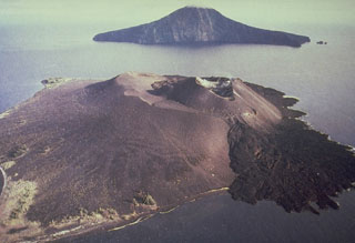
John Seach visited on 12 August and found that the volcano was not erupting then, but was steaming vigorously on the N side of the summit crater. Pulses of steam every minute reached 20 m above the summit. Lava bombs, 0.5 m in diameter, littered the old crater rim (840 m SE of the of the summit at 167 m elevation) at a density of 1 /m2. The bombs left 1.5-m-diameter impact craters up to 1.5 m in diameter at distances of 1.3 km SE of the summit. The fresh impact craters were caused by both lithic and lava bombs. Observers on a boat 1.5 km W of the volcano noticed a strong sulfur smell. The top 150 m of the active cone was steaming from multiple locations. On the NW side, 60 m below the summit, a fumarole emitted blue gas.
During 3-9 September the number of explosion and volcanic earthquakes increased, but the number of small explosion earthquakes sharply decreased 12-18 September. Krakatau remained at Alert Level 2 (on a scale of 1-4).
Geological Summary. The renowned Krakatau (frequently mis-named as Krakatoa) volcano lies in the Sunda Strait between Java and Sumatra. Collapse of an older edifice, perhaps in 416 or 535 CE, formed a 7-km-wide caldera. Remnants of that volcano are preserved in Verlaten and Lang Islands; subsequently the Rakata, Danan, and Perbuwatan cones were formed, coalescing to create the pre-1883 Krakatau Island. Caldera collapse during the catastrophic 1883 eruption destroyed Danan and Perbuwatan, and left only a remnant of Rakata. This eruption caused more than 36,000 fatalities, most as a result of tsunamis that swept the adjacent coastlines of Sumatra and Java. Pyroclastic surges traveled 40 km across the Sunda Strait and reached the Sumatra coast. After a quiescence of less than a half century, the post-collapse cone of Anak Krakatau (Child of Krakatau) was constructed within the 1883 caldera at a point between the former Danan and Perbuwatan cones. Anak Krakatau has been the site of frequent eruptions since 1927.
Information Contacts: Dali Ahmad, Volcanological Survey of Indonesia (VSI), Jalan Diponegoro No. 57, Bandung 40122, Indonesia (URL: http://www.vsi.esdm.go.id/); Darwin Volcanic Ash Advisory Centre (VAAC), Bureau of Meteorology, Northern Territory Regional Office, PO Box 40050, Casuarina, NT 0811, Australia (URL: http://www.bom.gov.au/info/vaac/); John Seach, P.O. Box 16, Chatsworth Island, NSW 2469, Australia.

