Report on Nyamulagira (DR Congo) — December 2001

Bulletin of the Global Volcanism Network, vol. 26, no. 12 (December 2001)
Managing Editor: Richard Wunderman.
Nyamulagira (DR Congo) MODIS data for February 2001 eruption; no January 2002 eruption
Please cite this report as:
Global Volcanism Program, 2001. Report on Nyamulagira (DR Congo) (Wunderman, R., ed.). Bulletin of the Global Volcanism Network, 26:12. Smithsonian Institution. https://doi.org/10.5479/si.GVP.BGVN200112-223020
Nyamulagira
DR Congo
1.408°S, 29.2°E; summit elev. 3058 m
All times are local (unless otherwise noted)
The eruption that began on 6 February 2001 (BGVN 26:03) continued through at least early April. An update from the Goma Volcanological Observatory since our last report stated that the February eruption was preceded by swarm of low-frequency earthquakes that began on 16 December 2000. The eruption started from the summit caldera of Nyamuragira and formed four cones: two on the N flank, one on the S flank, and one inside the caldera. The two main cones were symmetrical and located on the N (Amani) and S (Tumayhini) flanks, along the fissure connecting Nyamuragira and Nyiragongo. Lava flows extended up to 15 km from the two main cones. Ash fell up to 20 km away, damaging farmland and causing health problems.
The Hawaii Institute of Geophysics and Planetology at the School of Ocean and Earth Science Technology (HIGP/SOEST) tracked the eruption using MODIS (Moderate Resolution Imaging Spectroradiometer) global hot-spot data. No hot spots were seen at Nyamuragira until 7 February 2001. Figures 20 and 21 show examples of the hot spot maps for Nyamuragira during 7-12 February.
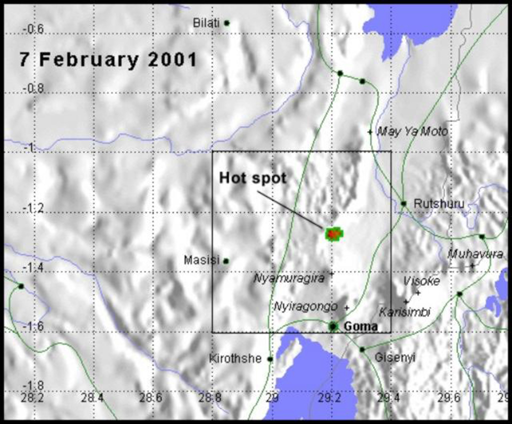 |
Figure 20. On 7 February 2001 at Nyamuragira the first-detected hot spot, a ~ 7 x 5 km anomaly, was seen on MODIS satellite imagery on the N flank of the volcano centered 7-10 km due N of the summit. The rectangle indicates the area shown in the following figure. Courtesy HIGP/SOEST. |
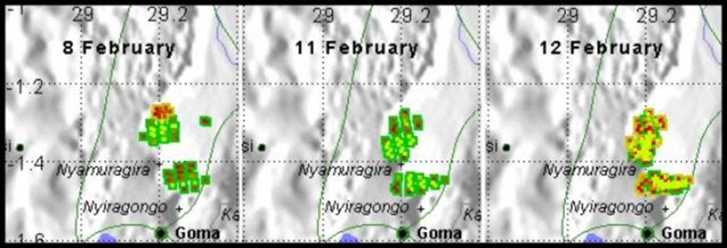 |
Figure 21. MODIS satellite imagery over Nyamuragira and vicinity revealed a series of hot-spot anomalies on 8, 11, and 12 February 2001. Compared to the anomaly seen on the previous day, on the 8th, the similarly situated N flank anomaly had increased in size. In addition, a second anomaly (~ 13 x 6 km) was conspicuous just SSE of the summit. On 11and 12 February the two anomalies remained similar to each other and to those on the 8 February image, though the anomalies become less circular than those of the 7 and 8 February images. The 11-12 February images contained a N-flank anomaly that trended NNE for ~ 22 km and the S-flank anomaly trended E for ~ 17 km. Courtesy HIGP/SOEST. |
As of 10 March, no lava fountains were observed and all flows had stopped. Only very dense "smoke" was observed coming from the cones. Unlike previous eruptions at Nyamuragira, no significant high-frequency earthquakes were observed; these usually signal the end of the eruption.
After 15 March through at least July 2001, the same seismic patterns that preceded the February eruption were observed. During the end of June, the Goma Volcanological Observatory reported that the magnitude of the low-frequency earthquakes and the amplitude of volcanic tremor had increased significantly. Scientists believed this increased activity could signal a large eruption sometime in the near future. The high seismic activity could also be related to regeneration of the Nyamuragira lava lake or to activity of the Nyiragongo lava lake.
False eruption report, January 2002. Rumors of a new eruption at Nyamuragira circulated soon after a 17 January eruption at Nyiragongo (see this Bulletin). Ash was allegedly ejected from the N flank of Nyamuragira on 22 January, but the reports could not be confirmed because of poor visibility. According to the United Nations Office for the Coordination of Humanitarian Affairs (OCHA), volcanologists determined that ash observed in Goma on 22 January originated from the collapse of Nyiragongo's inner crater and not from a new eruption at Nyamuragira.
Geological Summary. Africa's most active volcano, Nyamulagira (also known as Nyamuragira), is a massive high-potassium basaltic shield about 25 km N of Lake Kivu and 13 km NNW of the steep-sided Nyiragongo volcano. The summit is truncated by a small 2 x 2.3 km caldera that has walls up to about 100 m high. Documented eruptions have occurred within the summit caldera, as well as from the numerous flank fissures and cinder cones. A lava lake in the summit crater, active since at least 1921, drained in 1938, at the time of a major flank eruption. Recent lava flows extend down the flanks more than 30 km from the summit as far as Lake Kivu; extensive lava flows from this volcano have covered 1,500 km2 of the western branch of the East African Rift.
Information Contacts: Dieudonné Wafula, Observatore Volcanologie de Goma (RDC-E), Goma, Democratic Republic of Congo; Andy Harris, Eric Pilger and Luke Flynn, Hawaii Institute of Geophysics and Planetology at the School of Ocean and Earth Science Technology (HIGP/SOEST), University of Hawaii, 2525 Correa Road, Honolulu, HI 96822; United Nations Office for the Coordination of Humanitarian Affairs (OCHA), United Nations, New York, NY 10017 USA (URL: https://reliefweb.int/).