Report on Cotopaxi (Ecuador) — December 2002

Bulletin of the Global Volcanism Network, vol. 27, no. 12 (December 2002)
Managing Editor: Richard Wunderman.
Cotopaxi (Ecuador) First anomalous seismicity since 1975 begins in October 2001
Please cite this report as:
Global Volcanism Program, 2002. Report on Cotopaxi (Ecuador) (Wunderman, R., ed.). Bulletin of the Global Volcanism Network, 27:12. Smithsonian Institution. https://doi.org/10.5479/si.GVP.BGVN200212-352050
Cotopaxi
Ecuador
0.677°S, 78.436°W; summit elev. 5911 m
All times are local (unless otherwise noted)
The last Cotopaxi report (SEAN 01:03) described a decline in activity during December 1975. Beginning in October 2001, anomalous seismic activity was registered. Seismicity increased further during November 2001-January 2002, and at times was up to seven times the normal level (tables 1 and 2). During this period, other seismic signals were registered that were distinct from those during the 13 previous years of monitoring, including: tornillos, explosion events, bands of harmonic tremor sometimes lasting a few minutes, and deep, high-energy long-period (LP) events registered away from the volcano (at the Antisana and Guagua Pichincha stations). Seismic observations and statistics were compiled using station "VCl," located ~4 km NE of the volcano. Earthquake locations were determined using records from the seven seismic stations on different flanks of Cotopaxi, and for higher-energy events with stations of the National network.
Table 1. Monthly seismicity at Cotopaxi during 2001-2002. Data includes Total and Daily averages for long-period (LP) events, hybrid events, volcano-tectonic (VT) events, tornillo events, and all earthquakes. Courtesy IG.
| Date | LP Total | LP Daily Avg | Hybrid Total | Hybrid Daily Avg | VT Total | VT Daily Avg | Tornillo Total | Tornillo Daily Avg | All Earthquakes Total | All Earthquakes Daily Avg |
| Jan 2001 | 336 | 10.8 | 0 | 0.0 | 18 | 0.6 | 0 | 0.0 | 354 | 11.4 |
| Feb 2001 | 185 | 6.6 | 0 | 0.0 | 4 | 0.1 | 0 | 0.0 | 189 | 6.8 |
| Mar 2001 | 319 | 10.3 | 1 | 0.0 | 10 | 0.3 | 0 | 0.0 | 320 | 10.3 |
| Apr 2001 | 280 | 9.3 | 0 | 0.0 | 26 | 0.9 | 0 | 0.0 | 306 | 10.2 |
| May 2001 | 241 | 7.8 | 7 | 0.2 | 10 | 0.3 | 0 | 0.0 | 248 | 8.0 |
| Jun 2001 | 243 | 8.1 | 11 | 0.4 | 53 | 1.8 | 0 | 0.0 | 307 | 10.2 |
| Jul 2001 | 262 | 8.5 | 2 | 0.1 | 9 | 0.3 | 0 | 0.0 | 273 | 8.8 |
| Aug 2001 | 241 | 7.8 | 0 | 0.0 | 9 | 0.3 | 0 | 0.0 | 250 | 8.1 |
| Sep 2001 | 394 | 13.1 | 9 | 0.3 | 9 | 0.3 | 0 | 0.0 | 412 | 13.7 |
| Oct 2001 | 555 | 17.9 | 0 | 0.0 | 7 | 0.2 | 0 | 0.0 | 562 | 18.1 |
| Nov 2001 | 432 | 14.4 | 57 | 1.9 | 400 | 13.3 | 4 | 0.1 | 893 | 29.8 |
| Dec 2001 | 516 | 16.6 | 169 | 5.5 | 729 | 23.5 | 0 | 0.0 | 1423 | 45.9 |
| Jan 2002 | 595 | 19.2 | 5 | 0.2 | 363 | 11.7 | 3 | 0.1 | 966 | 31.2 |
| Feb 2002 | 532 | 19.0 | 4 | 0.1 | 157 | 5.6 | 0 | 0.0 | 693 | 24.8 |
| Mar 2002 | 504 | 16.3 | 1 | 0.0 | 191 | 6.2 | 0 | 0.0 | 696 | 22.5 |
| Apr 2002 | 310 | 10.3 | 7 | 0.2 | 63 | 2.1 | 0 | 0.0 | 380 | 12.7 |
| May 2002 | 431 | 13.9 | 8 | 0.3 | 53 | 1.7 | 0 | 0.0 | 453 | 14.6 |
| Jun 2002 | 429 | 14.3 | 41 | 1.4 | 45 | 1.5 | 3 | 0.1 | 474 | 15.8 |
| Jul 2002 | 445 | 14.4 | 181 | 5.8 | 92 | 3.0 | 2 | 0.1 | 720 | 23.2 |
| Aug 2002 | 455 | 14.7 | 91 | 2.9 | 32 | 1.0 | 12 | 0.4 | 590 | 19.0 |
| Sep 2002 | 509 | 17.0 | 184 | 6.1 | 140 | 4.7 | 19 | 0.6 | 852 | 28.4 |
| Oct 2002 | 322 | 10.4 | 219 | 7.1 | 62 | 2.0 | 13 | 0.4 | 616 | 19.9 |
| Nov 2002 | 295 | 9.8 | 142 | 4.7 | 64 | 2.1 | 2 | 0.1 | 503 | 16.8 |
| Dec 2002 | 233 | 9.0 | 120 | 4.6 | 48 | 1.5 | 1 | 0.0 | 402 | 16.1 |
Table 2. Comparison of average seismicity at Cotopaxi during 2001 and 2002. Courtesy IG.
| Year | Daily average | Monthly average | Total |
| 2001 | 15.4 | 461.4 | 5537 |
| 2002 | 20.4 | 612.1 | 7345 |
On 5 and 29 January 2002, two seismic clusters lasted an average of 2 hours and were composed mainly of LP and VT earthquakes. Most of the earthquakes were located at depths of 1-10 km beneath the summit. On 5 and 13 January small fumaroles were reported in the crater, and visible defrosting occurred on the upper E flank. A visit to the summit on 13 January revealed increased fumarolic activity compared to previous months. On 19 and 20 January observers reported gray plumes rising as high as 1,000 m.
During February and March activity diminished, and no seismic clusters were registered. Most of the earthquakes were located 1-10 km beneath the volcano. On 5 February roaring noises were heard from Mulaló and the refuges located on the flanks of the volcano. Strong fumarolic activity was also reported. On 6 February steam plumes rose ~300 m above the summit. On 27 February a small steam plume was reported exiting from the NW side of the crater. On 7 and 10 March small steam plumes originated from the W side of the crater. On 28 March harmonic tremor lasted for ~10 minutes.
Activity remained low during April-June. On 17 April a band of harmonic tremor lasted ~6 minutes with a maximum frequency of 4.3 Hz. During the first days of April small steam plumes were reported. During May LP earthquakes lasted up to a minute and saturated the seismometer for several seconds. On 20 May a seismic cluster of LP earthquakes lasted ~2 hours. On 8 and 14 May a white steam plume from the NE side of the volcano reached up to 200 m high. During June VT events mostly occurred ~10 km N of the crater. On 30 June a band of harmonic tremor lasted ~7 minutes with a maximum frequency of 1.7-5.2 Hz. Visits to the summit on 1 and 2 June revealed that fumarolic activity had diminished ~40% since January.
During July seismicity was at a moderate level with respect to the rest of 2002. During the first days of the month a series of LP events were registered that were large enough to be detected at distant stations, such as Antisana and Guagua Pichincha. The earthquakes had maximum frequencies of ~2.1 Hz and were generally 1-2 km beneath the summit. However, some events were located at depths of ~10 km. On 18 July at 2000 a band of low-frequency tremor lasted ~4 minutes. About 5 hours later a seismic cluster began that lasted for ~8 hours. The cluster consisted of ~110 total events, mostly hybrid (HB) and volcano-tectonic (VT). The earthquakes were located 1-4 km beneath the summit, and 2 LP events were located ~10 km deep.
Visitors to the summit on 6 July reported fumarolic activity in the zone of Yanasacha, a slight sulfur smell on the NE side, and noise generated by an avalanche on the E side. At the end of July reports indicated defrosting in the W zone. During August moderate seismicity was dominated by LP events at a depth of ~10 km.
Seismicity was again high in September 2002. A small cluster of VT earthquakes on 15 September lasted ~7 hours. During the first days of the month a visit to the crater revealed new fumaroles in the E and S zones. Defrosting continued in the W zone and left 40% of the W wall open.
During October seismic activity was low but the number of hybrid events increased compared to the previous months. Tectonic events were registered in the S and N zones up to ~7 km from the summit. Deep LP events decreased by ~50% compared to previous months.
Seismicity remained low during November and December. Less than 10% of VT events were registered in the N sector. No fumarolic or other surface activity was observed. During December seismic events were located 1-7 km beneath the summit. On 7 December people in Yanahurco reported dark brown plumes rising from the crater.
Seismicity since 1989 clearly shows an increase in recent months (figure 1). The 2001 seismic events were registered at 1-10 km beneath the volcano, but ~90% occurred at 2-4 km and showed little migration. The 2002 activity was variable, from a high of 966 events in January to a low of 420 events in April. Mostly LP events occurred with some VT events during the first half of the year, and later mostly LP events with hybrids during the second half of the year. On the basis of 2002 seismic activity, a new injection of magma did not occur, and the anomalies in July and September were the result of the movement of gas from magma intrusion that occurred during the last months of 2001.
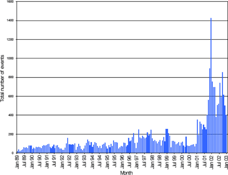 |
Figure 1. Graph of the total registered monthly events at Cotopaxi during 1989-2002. The activity increased beginning in November 2001 and has since remained above background levels. Courtesy of IG. |
Geological Summary. The symmetrical, glacier-covered, Cotopaxi stratovolcano is Ecuador's most well-known volcano and one of its most active. The steep-sided cone is capped by nested summit craters, the largest of which is about 550 x 800 m in diameter. Deep valleys scoured by lahars radiate from the summit of the andesitic volcano, and large andesitic lava flows extend to its base. The modern edifice has been constructed since a major collapse sometime prior to about 5,000 years ago. Pyroclastic flows (often confused in historical accounts with lava flows) have accompanied many explosive eruptions, and lahars have frequently devastated adjacent valleys. Strong eruptions took place in 1744, 1768, and 1877. Pyroclastic flows descended all sides of the volcano in 1877, and lahars traveled more than 100 km into the Pacific Ocean and western Amazon basin. Smaller eruptions have been frequent since that time.
Information Contacts: Geophysical Institute (IG), Escuela Politécnica Nacional, Apartado 17-01-2759, Quito, Ecuador.