Report on Nyamulagira (DR Congo) — January 2003

Bulletin of the Global Volcanism Network, vol. 28, no. 1 (January 2003)
Managing Editor: Edward Venzke.
Nyamulagira (DR Congo) Infrared satellite data from the 25 July 2002 eruption
Please cite this report as:
Global Volcanism Program, 2003. Report on Nyamulagira (DR Congo) (Venzke, E., ed.). Bulletin of the Global Volcanism Network, 28:1. Smithsonian Institution. https://doi.org/10.5479/si.GVP.BGVN200301-223020
Nyamulagira
DR Congo
1.408°S, 29.2°E; summit elev. 3058 m
All times are local (unless otherwise noted)
An eruption began at Nyamuragira on 25 July 2002 (BGVN 27:07). Flights on 1 and 3 August confirmed that the eruption was continuing at a high rate, but another look on 27 September showed that the eruption had ceased (BGVN 27:10). The eruption was observed in MODIS thermal satellite imagery (1-km2 pixel size).
Initial activity was detected on 25 July at 2040 UTC, with a large (57-pixel) thermal anomaly on the S and N flanks of the volcano. The anomaly grew in size, with an image on 27 July showing a large anomaly on the N flank and a subordinate anomaly on the S flank. On all subsequent days the anomaly was limited to the N flank. The anomaly reached a maximum size of 78 pixels on 1 August, at which point it extended approximately 12-15 pixels (or around 12-15 km) along its longest dimension (figure 23). After this point the size and intensity of the anomaly rapidly diminished (detected anomalies after mid-August were no more than 8 pixels in size). The last detected anomaly at Nyamuragira occurred on 1 October. Figures 24 and 25 show the number of anomalous pixels and the sum of the radiance for the entire eruptive event.
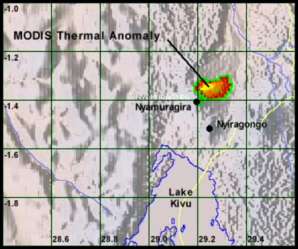 |
Figure 23. MODIS imagery on 1 August 2002 showed the maximum number of anomalous pixels (78) for the July-August eruption at Nyamuragira. Courtesy HIGP/SOEST. |
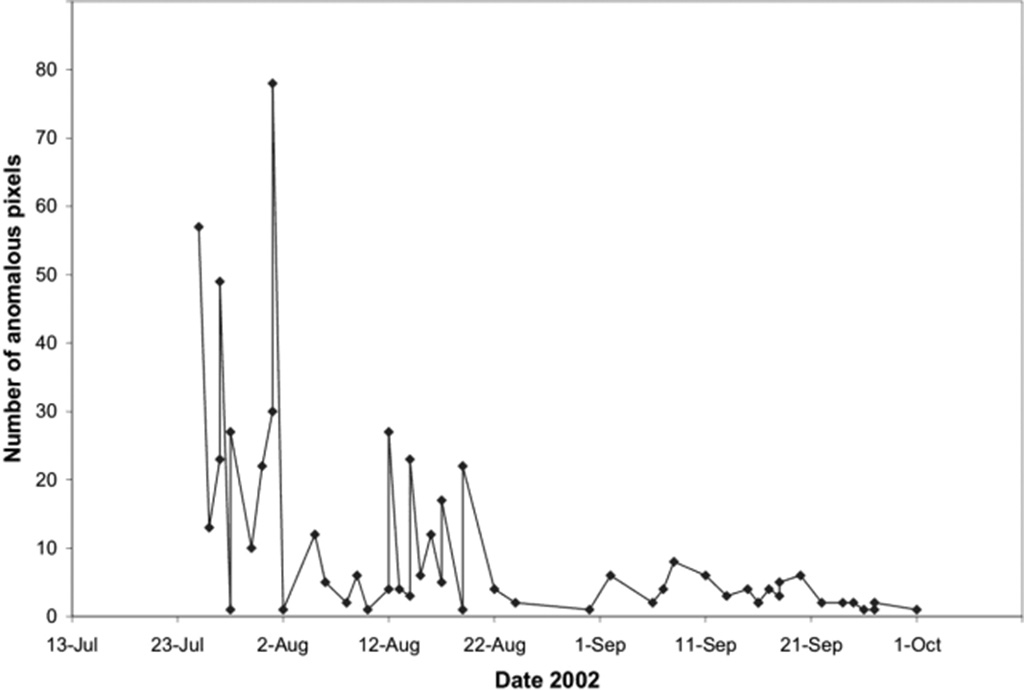 |
Figure 24. Total number of anomalous pixels visible on MODIS imagery during and following the July-August 2002 eruption of Nyamuragira. Courtesy HIGP/SOEST. |
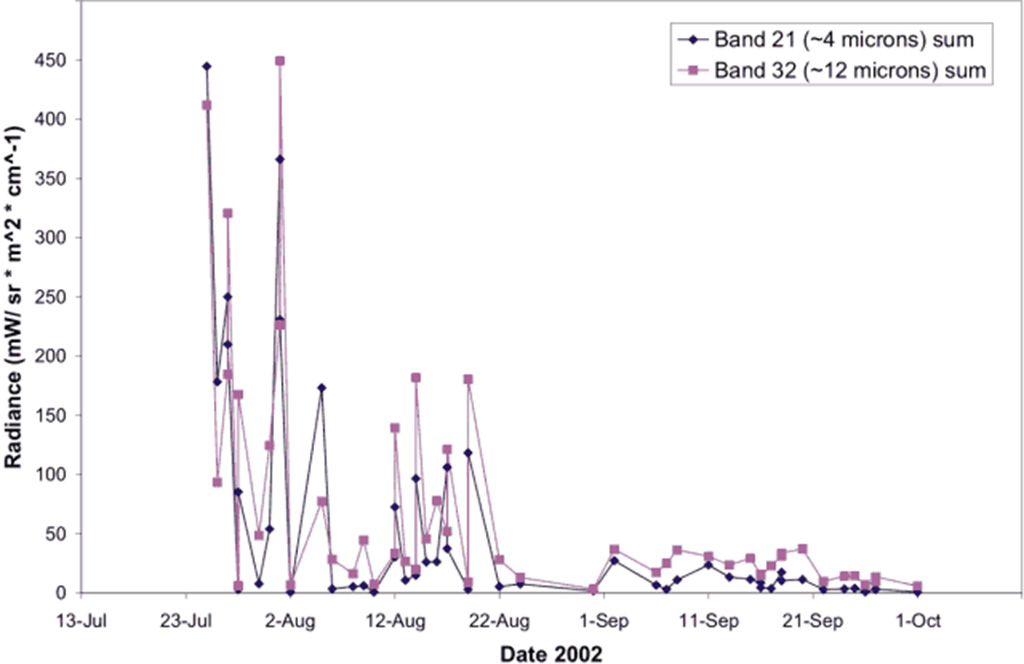 |
Figure 25. Sum of the radiance values for bands 21 and 32 on MODIS imagery during and following the July-August 2002 eruption of Nyamuragira. Courtesy HIGP/SOEST. |
Geological Summary. Africa's most active volcano, Nyamulagira (also known as Nyamuragira), is a massive high-potassium basaltic shield about 25 km N of Lake Kivu and 13 km NNW of the steep-sided Nyiragongo volcano. The summit is truncated by a small 2 x 2.3 km caldera that has walls up to about 100 m high. Documented eruptions have occurred within the summit caldera, as well as from the numerous flank fissures and cinder cones. A lava lake in the summit crater, active since at least 1921, drained in 1938, at the time of a major flank eruption. Recent lava flows extend down the flanks more than 30 km from the summit as far as Lake Kivu; extensive lava flows from this volcano have covered 1,500 km2 of the western branch of the East African Rift.
Information Contacts: Matt Patrick, Andy Harris, Luke Flynn, Robert Wright, Harold Garbiel, and Eric Pilger, HIGP/SOEST, University of Hawaii at Manoa, HI 96822 USA.