Report on Heard (Australia) — January 2003
Bulletin of the Global Volcanism Network, vol. 28, no. 1 (January 2003)
Managing Editor: Edward Venzke.
Heard (Australia) Infrared data show previously unknown activity during May-June 2000
Please cite this report as:
Global Volcanism Program, 2003. Report on Heard (Australia) (Venzke, E., ed.). Bulletin of the Global Volcanism Network, 28:1. Smithsonian Institution. https://doi.org/10.5479/si.GVP.BGVN200301-234010
Heard
Australia
53.106°S, 73.513°E; summit elev. 2745 m
All times are local (unless otherwise noted)
Between 13 May 2000 and 30 January 2003, thermal alerts on Heard Island occurred on the following dates: 24 May; 3, 5, and 6 June; 25 September; 29 October; 5, 15, 19, and 24 November; 16, 17, 26, and 30 December 2000; and 2 February 2001 (figure 7). Since then no further thermal alerts have been recorded. There have been no reports of May-June 2000 activity on Heard Island published in the Bulletin. However, Rothery and Coppola are confident that the MODIS data prove high-temperature volcanic activity at these times. The late-2000 period of MODIS thermal alerts is substantiated by reports from ships and helicopters. The first of these, "fumarolic activity" on 19 October (BGVN 25:11), is 24 days later than the first MODIS thermal alert in this period. A fresh lava flow was suspected but unproven on 3 February (BGVN 26:02), and two incandescent vents were photographed on the same day (BGVN 26:03). The interpretation of the MODIS data is that lava effusion is likely. The locations of the alert pixels (figure 8) suggest that activity was on the WSW side of the summit, and may have extended about halfway to the shore.
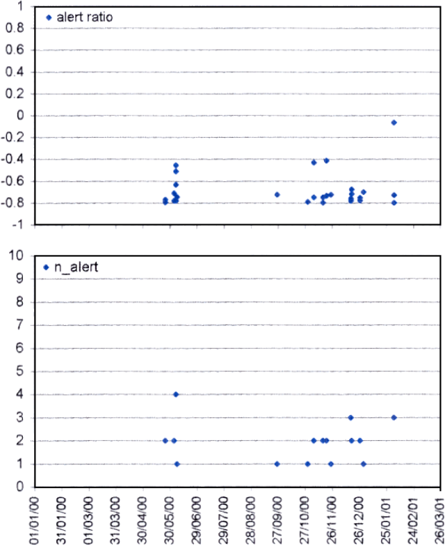 |
Figure 7. MODIS detected alerts on Heard during January 2000-March 2001. Courtesy of Diego Coppola and David Rothery, The Open University. |
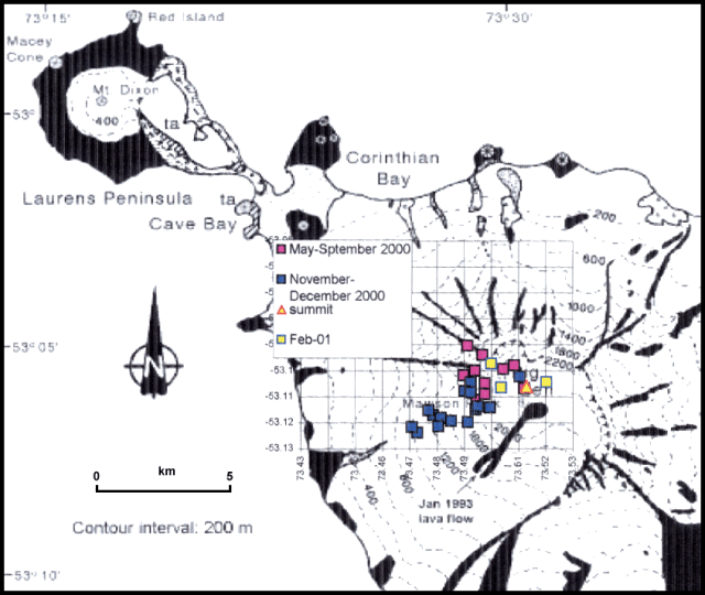 |
Figure 8. Locations of alert-pixels on Heard during 2001-2002. Grid squares are 1 km on a side. Base map from BGVN 17:05 (after Barling, 1990). Courtesy of Diego Coppola and David Rothery, The Open University. |
Reference. Barling, J., 1990, Heard and McDonald Islands, in Le Masurier, W., and Thomson, J., eds., Volcanoes of the Antarctic Plate and southern Oceans: American Geophysical Union, Washington DC, p. 435-441.
Geological Summary. Heard Island on the Kerguelen Plateau in the southern Indian Ocean consists primarily of the emergent portion of two volcanic structures. The large glacier-covered composite basaltic-to-trachytic cone of Big Ben comprises most of the island, and the smaller Mt. Dixon lies at the NW tip of the island across a narrow isthmus. Little is known about the structure of Big Ben because of its extensive ice cover. The active Mawson Peak forms the island's high point and lies within a 5-6 km wide caldera breached to the SW side of Big Ben. Small satellitic scoria cones are mostly located on the northern coast. Several subglacial eruptions have been reported at this isolated volcano, but observations are infrequent and additional activity may have occurred.
Information Contacts: David A. Rothery and Diego Coppola, Department of Earth Sciences, The Open University, Milton Keynes MK 6AA, United Kingdom.