Report on Lopevi (Vanuatu) — January 2003

Bulletin of the Global Volcanism Network, vol. 28, no. 1 (January 2003)
Managing Editor: Edward Venzke.
Lopevi (Vanuatu) Infrared data corroborate and refine timing of known activity
Please cite this report as:
Global Volcanism Program, 2003. Report on Lopevi (Vanuatu) (Venzke, E., ed.). Bulletin of the Global Volcanism Network, 28:1. Smithsonian Institution. https://doi.org/10.5479/si.GVP.BGVN200301-257050
Lopevi
Vanuatu
16.507°S, 168.346°E; summit elev. 1413 m
All times are local (unless otherwise noted)
During 2001-2002, MODIS alerts occurred only in June 2001 (figure 18). The first anomaly was detected on 9 June at 2210. This consisted of three alert-pixels with a maximum alert ratio of -0.299, and can be attributed to lava flows from a new vent 200 m above sea level on the NW side of the cone, which appeared in association with a plume-forming eruption on 8 June at around 1100 (BGVN 26:08). The only other MODIS alert was 14 June at 2225 local time, and consisted of two pixels closer to the summit (figure 6). According to a local guide (BGVN 26:08), a new flow was erupted in roughly this location on 15 June. MODIS alert data provide evidence that emplacement of this flow actually began during the previous night.
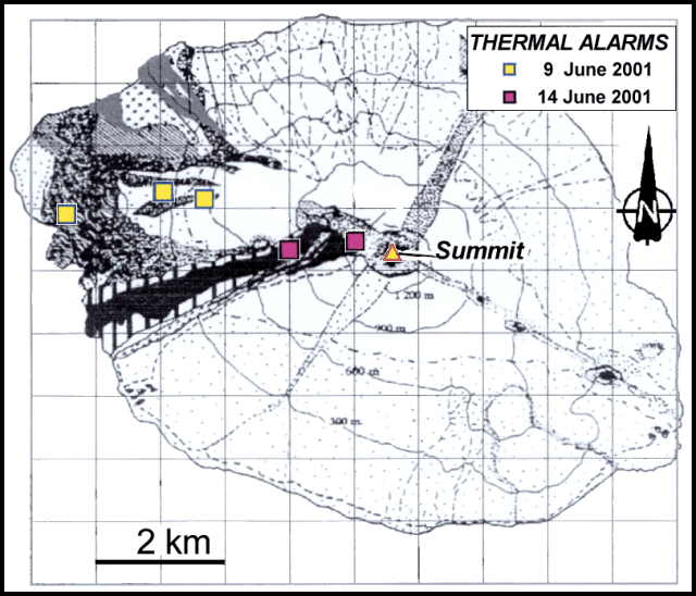 |
Figure 18. Locations of alert-pixels on Lopevi during 2001-2002. Courtesy of Diego Coppola and David Rothery, The Open University. Base map is from BGVN 26:08; courtesy of Institut de recherche pour le développement (IRD), Vanuatu. |
Geological Summary. The small 7-km-wide conical island of Lopevi, known locally as Vanei Vollohulu, is one of Vanuatu's most active volcanoes. A small summit crater containing a cinder cone is breached to the NW and tops an older cone that is rimmed by the remnant of a larger crater. The basaltic-to-andesitic volcano has been active during historical time at both summit and flank vents, primarily along a NW-SE-trending fissure that cuts across the island, producing moderate explosive eruptions and lava flows that reached the coast. Historical eruptions at the 1413-m-high volcano date back to the mid-19th century. The island was evacuated following major eruptions in 1939 and 1960. The latter eruption, from a NW-flank fissure vent, produced a pyroclastic flow that swept to the sea and a lava flow that formed a new peninsula on the western coast.
Information Contacts: Diego Coppola and David A. Rothery, Department of Earth Sciences, The Open University, Milton Keynes, MK7 6AA, United Kingdom.