Report on Piton de la Fournaise (France) — February 2003

Bulletin of the Global Volcanism Network, vol. 28, no. 2 (February 2003)
Managing Editor: Edward Venzke.
Piton de la Fournaise (France) Infrared data from November-December 2002 eruption
Please cite this report as:
Global Volcanism Program, 2003. Report on Piton de la Fournaise (France) (Venzke, E., ed.). Bulletin of the Global Volcanism Network, 28:2. Smithsonian Institution. https://doi.org/10.5479/si.GVP.BGVN200302-233020
Piton de la Fournaise
France
21.244°S, 55.708°E; summit elev. 2632 m
All times are local (unless otherwise noted)
Following the 16 November-3 December 2002 eruption (BGVN 27:11), the Observatoire volcanologique du Piton de la Fournaise reported on 19 December that very strong seismicity had continued at a rate of more than 1,000 earthquakes per day. The earthquakes were located a few hundred meters below Dolomieu crater.
MODIS tracking of effusive activity during 2000-2002. The November-December 2002 eruption was detected by the Hawai'i Institute of Geophysics and Planetology MODIS thermal alert system (http://modis.higp.hawaii.edu/). The eruption was apparent as a major hot spot in the SW sector of Reunion (figure 66). The first image on which activity was flagged was that of 1030 (0630 UTC) on 16 November 2002. At that point the flagged anomaly was six 1-km pixels (E-W) by 2-3 pixels (N-S). The hot spot attained roughly the same locations and dimensions on all subsequent images, where hot pixels were flagged on 16 images during November 16-3 December 2002. The exception was an image acquired at 2255 (1855 UTC) on 30 November (figure 66), on which the hot spot attained its largest dimensions of ~12 x 5 pixels. The increase in hot spot dimensions towards the end of November is also apparent in the radiance trace (figure 67). However, without examination of the raw images HIGP scientists cannot determine from the hot spot data alone whether this recovery was due to an increase in activity or an improvement in cloud conditions. This was the 6th eruption of Piton de la Fournaise tracked by the MODIS thermal alert (Flynn et al., 2002; Wright et al., 2002) since its inception during April 2000 (figure 68).
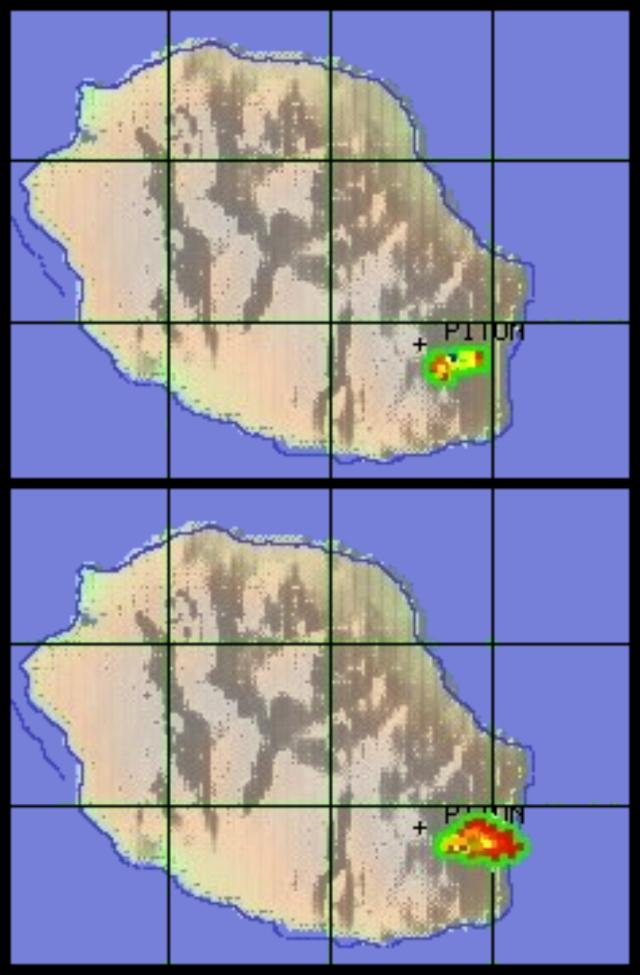 |
Figure 66. Hot-spot pixels flagged at Piton de la Fournaise by the MODIS thermal alert at 0630 UTC on 16 November 2002 (top) and 1855 UTC on 30 November 2002 (bottom). Courtesy of the HIGP Thermal Alerts Team. |
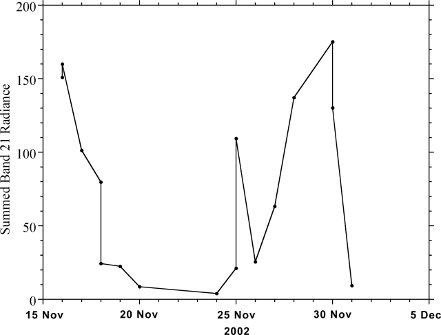 |
Figure 67. Piton de la Fournaise hot spot radiance detected by MODIS during 15 November-5 December 2002. Courtesy of the HIGP Thermal Alerts Team. |
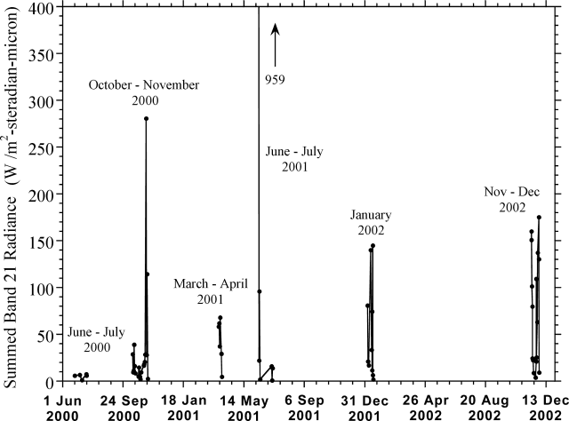 |
Figure 68. Piton de la Fournaise hot spot radiance detected by MODIS during April 2000-December 2002. Courtesy of the HIGP Thermal Alerts Team. |
References. Wright, R., Flynn, L.P., Garbeil, H., Harris, A.J.L., and Pilger, E., 2002, Automated volcanic eruption detection using MODIS: Remote Sensing of Environment, v. 82, p. 135-155.
Flynn, L.P., Wright, R., Garbeil, H., Harris, A.J.L., and Pilger, E, 2002, A global thermal alert using MODIS: initial results from 2000-2001: Advances in Environmental Monitoring and Modeling (http://www.kcl.ac.uk/kis/ schools/hums/geog/advemm.html), v. 1, no. 3, p. 5-36.
Geological Summary. Piton de la Fournaise is a massive basaltic shield volcano on the French island of Réunion in the western Indian Ocean. Much of its more than 530,000-year history overlapped with eruptions of the deeply dissected Piton des Neiges shield volcano to the NW. Three scarps formed at about 250,000, 65,000, and less than 5,000 years ago by progressive eastward slumping, leaving caldera-sized embayments open to the E and SE. Numerous pyroclastic cones are present on the floor of the scarps and their outer flanks. Most recorded eruptions have originated from the summit and flanks of Dolomieu, a 400-m-high lava shield that has grown within the youngest scarp, which is about 9 km wide and about 13 km from the western wall to the ocean on the E side. More than 150 eruptions, most of which have produced fluid basaltic lava flows, have occurred since the 17th century. Only six eruptions, in 1708, 1774, 1776, 1800, 1977, and 1986, have originated from fissures outside the scarps.
Information Contacts: Observatoire volcanologique du Piton de la Fournaise, 14 RN3, le 27Km, 97418 La Plaine des Cafres, La Réunion, France; Andy Harris, Luke Flynn, Harold Garbeil, Eric Pilger, Matt Patrick, and Robert Wright, HIGP Thermal Alerts Team, Hawai'i Institute of Geophysics and Planetology (HIGP) / School of Ocean and Earth Science and Technology (SOEST), University of Hawai'i, 2525 Correa Road, Honolulu, HI 96822, USA (URL: http://modis.higp.hawaii.edu/).