Report on Piton de la Fournaise (France) — May 2003

Bulletin of the Global Volcanism Network, vol. 28, no. 5 (May 2003)
Managing Editor: Edward Venzke.
Piton de la Fournaise (France) Eruption on 30 May generates lava flows within Dolomieu crater
Please cite this report as:
Global Volcanism Program, 2003. Report on Piton de la Fournaise (France) (Venzke, E., ed.). Bulletin of the Global Volcanism Network, 28:5. Smithsonian Institution. https://doi.org/10.5479/si.GVP.BGVN200305-233020
Piton de la Fournaise
France
21.244°S, 55.708°E; summit elev. 2632 m
All times are local (unless otherwise noted)
Eruptions are common at Piton de la Fournaise, with the most recent activity occurring in January 2002 (BGVN 26:12) and November-December 2002 (BGVN 27:11). At the end of the November 2002 eruption, seimicity beneath Dolomieu crater increased from 28 November to 23 December. On 22 December there were 5,700 seismic events recorded. At 1002 on 23 December a magnitude 3 event occurred and seismicity stopped. The next day a new crater was observed in the SW part of the larger Dolomieu crater.
Since March 2003, the extensometer network and GPS measurements had indicated inflation of Piton de la Fournaise. A new eruption began on 30 May within Dolomieu crater. The eruption proceeded in multiple phases through at least 24 June; activity through 6 June is reported below.
Seismicity increased slightly on 28 May. At 1137 on the morning of 30 May a seismic crisis began that lasted 17 minutes with a total of 34 events. Tremor appeared at 1155 beneath Dolomieu crater, and an eruption started within the pit crater formed on 23 December 2002. Lava fountaining was observed until 1400, after which most surface activity stopped. A lava flow ~400 m long and 250 m wide extended into the W part of Dolomieu. The total volume of lava emitted during the 30 May activity was estimated to be 0.2-0.3 x 10⁶ m3. Seismicity beneath the crater continued, with intermittent weak tremor being registered through 3 June. No deflation was detected, and there was strong degassing in the collapse area.
On 4 June at 1155 the eruption started again from the same site, enlarging the lava flow in the W part of Dolomieu crater. Lava fountains reached 15 m in height. Steady lava emission continued into 6 June (figures 69 and 70). Volcanic tremor remained stable until the morning of 6 June, when a decreasing tendency was noted. After a short phreatic eruption, the second phase of this eruption stopped on the evening of 6 June. The lava-flow field had grown to ~600 x 400 m in size by that time (figure 71).
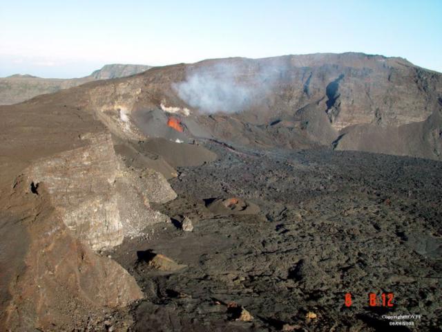 |
Figure 69. Photograph of the SW part of Dolomieu crater at Piton de la Fournaise at 0812 on 6 June 2003 showing the active vent and part of the recent lava-flow field. View is towards the W. Courtesy of OVPF. |
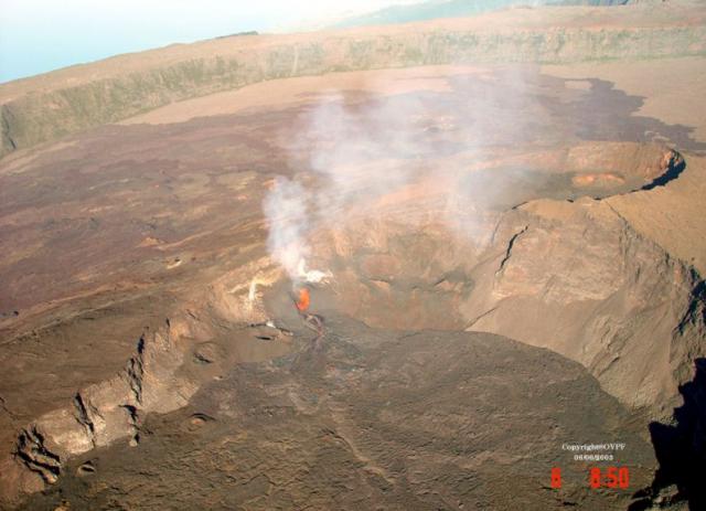 |
Figure 70. Photograph of the W part of Dolomieu crater at Piton de la Fournaise at 0850 on 6 June 2003 showing the active vent and most of the recent lava-flow field. View is towards the SW. Courtesy of OVPF. |
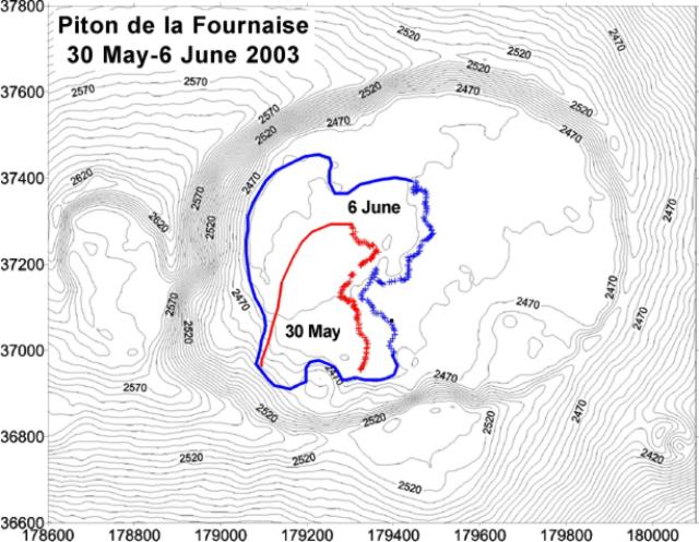 |
Figure 71. Topographic map of Dolomieu crater at Piton de la Fournaise showing the extent of the lava-flow field on 30 May and 6 June 2003. Elevations are in meters, and the Gauss-Laborde Piton des Neiges system is used for the map coordinates. Courtesy of OVPF. |
Geological Summary. Piton de la Fournaise is a massive basaltic shield volcano on the French island of Réunion in the western Indian Ocean. Much of its more than 530,000-year history overlapped with eruptions of the deeply dissected Piton des Neiges shield volcano to the NW. Three scarps formed at about 250,000, 65,000, and less than 5,000 years ago by progressive eastward slumping, leaving caldera-sized embayments open to the E and SE. Numerous pyroclastic cones are present on the floor of the scarps and their outer flanks. Most recorded eruptions have originated from the summit and flanks of Dolomieu, a 400-m-high lava shield that has grown within the youngest scarp, which is about 9 km wide and about 13 km from the western wall to the ocean on the E side. More than 150 eruptions, most of which have produced fluid basaltic lava flows, have occurred since the 17th century. Only six eruptions, in 1708, 1774, 1776, 1800, 1977, and 1986, have originated from fissures outside the scarps.
Information Contacts: Observatoire volcanologique du Piton de la Fournaise (OVPF), Institut de Physique du Globe de Paris, 14 RN3, le 27Km, 97418 La Plaine des Cafres, La Réunion, France.