Report on Piton de la Fournaise (France) — June 2003

Bulletin of the Global Volcanism Network, vol. 28, no. 6 (June 2003)
Managing Editor: Edward Venzke.
Piton de la Fournaise (France) Lava flows in Dolomieu crater; eruption ends 7 July
Please cite this report as:
Global Volcanism Program, 2003. Report on Piton de la Fournaise (France) (Venzke, E., ed.). Bulletin of the Global Volcanism Network, 28:6. Smithsonian Institution. https://doi.org/10.5479/si.GVP.BGVN200306-233020
Piton de la Fournaise
France
21.244°S, 55.708°E; summit elev. 2632 m
All times are local (unless otherwise noted)
Reports from the Observatoire Volcanologique du Piton de la Fournaise (OVPF) indicated ongoing eruptive activity from late May to 6 June 2003 (BGVN 28:05). The activity was characterized by sporadic seismicity, degassing from fissures, and lava flows. Inflation of Piton de la Fournaise was observed beginning in March 2003, without later indications of deflation as of July 2003. Eruptive activity within Dolomieu crater continued until 7 July.
Eruptive tremor had completely disappeared by 8 June, and on the 10th that phase of the eruption was considered to be finished. About thirty small earthquakes were observed, caused by minor collapses. The extensometric network continued to show an opening of cracks at Magne and Chateau-Fort. On 10 June, 71 earthquakes were observed, the strongest of which had magnitudes of 1.4-2.0. The earthquakes were located ~400 m under Dolomieu in the SW part near the site of the 30 May-4 June eruption. Extensometers continued to indicate swelling of the volcano, but no summit inflation was observed during the eruption.
On 13 June at 0308 new eruption tremor appeared within Dolomieu crater. A helicopter overflight confirmed that the eruption continued from the same site as the first two eruptive phases. Such a scenario was expected because the extensometer network showed continuous opening of the monitored fissures. Seismicity on 12 June had decreased compared to the previous two days, with a lack of very low amplitude earthquakes. That day eruptive tremor began without being preceded by even a small earthquake.
During the morning of 14 June eruption tremor was stable and practically constant; other seismic events did not register. On 15 June at 0600, the tremor entirely disappeared. Crater observations showed that lava flows had extended to the N wall of Dolomieu crater, covering almost half of the crater floor as of 16 June (figure 72). After a cessation of several days, the eruption began again on 21 June at about 2330. After a progressive increase of tremor in the hours that followed, the situation stabilized, and the tremor then strongly decreased.
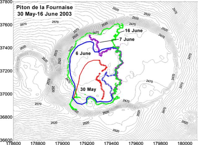 |
Figure 72. Topographic map of Dolomieu crater at Piton de la Fournaise showing the extent of the newly erupted lava-flow field on 30 May, 6 June, 7 June, and 16 June 2003. Elevations are in meters, and the Gauss-Laborde Piton des Neiges system is used for the map coordinates. Courtesy of OVPF. |
On 24 June the eruption was still in progress. The tremor increased strongly in the night and reached the maximum level of the preceding eruptive phases. Observations on 26 June showed two small openings in front of the principal cone. The first showed degassing, and the second, which was almost closed, emitted sporadic weak projections. Within 100 m of the cone an emission of a very fluid and degassed lava had produced significant flows. On 27 June the tremor had strongly diminished.
After 0630 on 28 June highly variable tremor related to "gas pistons," or regular degassing, was observed on a scale not previously seen at Piton de la Fournaise. Some lava flows in Dolomieu remained active. A small cone opposite the Piton kaf degassed strongly in time with the other gas explosions.
On 1and 2 July, no change in eruptive activity was observed. The tremor varied with a time interval of 12-13 minutes between total stop and maximum tremor amplitude. The eruption continued on 3 July, but on 4 July the tremor had diminished, and the tremor variations observed in past days were less pronounced. No lava projections were seen in the crater during this phase, and volcanic earthquakes were not detected until one occurred on 3 July. The eruption ended on 7 July.
Geological Summary. Piton de la Fournaise is a massive basaltic shield volcano on the French island of Réunion in the western Indian Ocean. Much of its more than 530,000-year history overlapped with eruptions of the deeply dissected Piton des Neiges shield volcano to the NW. Three scarps formed at about 250,000, 65,000, and less than 5,000 years ago by progressive eastward slumping, leaving caldera-sized embayments open to the E and SE. Numerous pyroclastic cones are present on the floor of the scarps and their outer flanks. Most recorded eruptions have originated from the summit and flanks of Dolomieu, a 400-m-high lava shield that has grown within the youngest scarp, which is about 9 km wide and about 13 km from the western wall to the ocean on the E side. More than 150 eruptions, most of which have produced fluid basaltic lava flows, have occurred since the 17th century. Only six eruptions, in 1708, 1774, 1776, 1800, 1977, and 1986, have originated from fissures outside the scarps.
Information Contacts: Observatoire Volcanologique du Piton de la Fournaise (OVPF), Institut de Physique du Globe de Paris, 14 RN3, le 27Km, 97418 La Plaine des Cafres, La Réunion, France (URL: http://www.ipgp.fr/fr/ovpf/observatoire-volcanologique-piton-de-fournaise).