Report on Popocatepetl (Mexico) — August 2003

Bulletin of the Global Volcanism Network, vol. 28, no. 8 (August 2003)
Managing Editor: Edward Venzke.
Popocatepetl (Mexico) Continuing intermittent eruptions; ashfall in June and July
Please cite this report as:
Global Volcanism Program, 2003. Report on Popocatepetl (Mexico) (Venzke, E., ed.). Bulletin of the Global Volcanism Network, 28:8. Smithsonian Institution. https://doi.org/10.5479/si.GVP.BGVN200308-341090
Popocatepetl
Mexico
19.023°N, 98.622°W; summit elev. 5393 m
All times are local (unless otherwise noted)
Volcanic activity at Popocatépetl during March-July 2003, as reported by the Centro Nacional de Prevención de Desastres (CENAPRED), was similar to that from July 2002 to February 2003 (BGVN 27:10 and 28:02). Activity was comprised principally of multiple exhalations (some with significant ash), volcano-tectonic (VT) earthquakes, and explosions. Daily exhalations averaged 10-30 during March, 5-25 during April and May, and _50 during July. VT earthquakes in these months were M 2-3 at depths of 2-5 km located E or SE of the volcano.
On 28 April and 10 May, low-frequency harmonic tremors during the VT events attained moderate, but significant, amplitude levels lasting 13 and 4 hours, respectively. Eruptive activity during June, presumed to be predominantly phreatic, increased and caused ash-bearing exhalations and explosions. Another significant tremor episode was detected on 8 June. Eruptions on 20 and 28 June caused minor ashfall on some towns near the volcano. During July, many exhalations were explosive and carried significant ash. The largest explosive events in July were recorded on 1, 15, 19, and 25. The event of 19 July (figure 48) caused light ashfall as far as the southern metropolitan area of Mexico City. Aerial photography of the crater on 30 April and 19 May indicated no evidence of new lava dome emplacement during the report period.
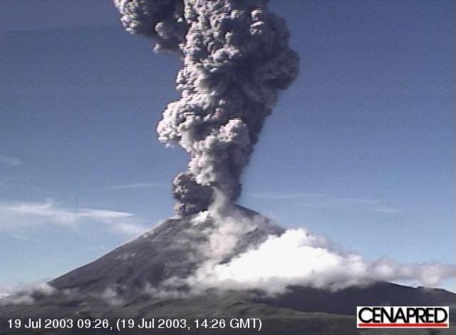 |
Figure 48. Photograph of an eruption at Popocatépetl volcano, 19 July 2003. Courtesy of CENAPRED. |
Geological Summary. Volcán Popocatépetl, whose name is the Aztec word for smoking mountain, rises 70 km SE of Mexico City to form North America's 2nd-highest volcano. The glacier-clad stratovolcano contains a steep-walled, 400 x 600 m wide crater. The generally symmetrical volcano is modified by the sharp-peaked Ventorrillo on the NW, a remnant of an earlier volcano. At least three previous major cones were destroyed by gravitational failure during the Pleistocene, producing massive debris-avalanche deposits covering broad areas to the south. The modern volcano was constructed south of the late-Pleistocene to Holocene El Fraile cone. Three major Plinian eruptions, the most recent of which took place about 800 CE, have occurred since the mid-Holocene, accompanied by pyroclastic flows and voluminous lahars that swept basins below the volcano. Frequent historical eruptions, first recorded in Aztec codices, have occurred since Pre-Columbian time.
Information Contacts: Angel Gómez Vázquez, Alicia Martinez Bringas, Roberto Quass Weppen, Enrique Guevara Ortiz, Gilberto Castela Pescina, and Javier Ortiz Castro, Centro Nacional de Prevención de Desastres (CENAPRED), Av. Delfín Madrigal No.665, Coyoacan, México D.F. 04360, Mexico (URL: https://www.gob.mx/cenapred/); Servando De la Cruz-Reyna and Carlos Valdez Gonzalez, Instituto de Geofísica, UNAM, Cd. Universitaria, Circuito Institutos, Coyoácan, México D.F. 04510, Mexico (URL: http://www.geofisica.unam.mx/).