Report on Klyuchevskoy (Russia) — April 2004
Bulletin of the Global Volcanism Network, vol. 29, no. 4 (April 2004)
Managing Editor: Edward Venzke.
Research and preparation by Don Gruber, Dave Charvonia.
Klyuchevskoy (Russia) Background seismicity March-April 2004; ash plumes on 8 April
Please cite this report as:
Global Volcanism Program, 2004. Report on Klyuchevskoy (Russia) (Venzke, E., ed.). Bulletin of the Global Volcanism Network, 29:4. Smithsonian Institution. https://doi.org/10.5479/si.GVP.BGVN200404-300260
Klyuchevskoy
Russia
56.056°N, 160.642°E; summit elev. 4754 m
All times are local (unless otherwise noted)
Unrest at Kliuchevskoi continued, with occasional and repeated explosions containing ash, gas, and steam that rose as high as 7.8 km altitude during January-April 2004. The alert level remained at orange.
Strombolian activity was reported in the central crater on 11-12 January and may have occurred again during 22-26 January. Gas-steam plumes extended up to 15 km in various directions during the report period; although one containing small amounts of ash, extended 75 km to the SW on 25 January.
Table 12 presents seismicity reported by KVERT including the number of large shallow earthquakes, their local magnitudes (Ml), and the range of tremor velocity. Many weak, shallow earthquakes also occurred each week. In overview, seismicity stood above background until about March, when it dropped to background, remaining there through 29 April. After February, instrumental measure of tremor (tremor velocity, table 2) declined. The details on the number and magnitude of large shallow earthquakes (which on the week ending 6 February had risen to ~ 430 Ml 1.2-2.0) ceased being a reported topic after February, although these earthquakes continued to be mentioned as occurring. Beginning in late February, earthquakes at depths up to 30 km were reported in moderate number ("deeper earthquakes"; table 2).
Table 12. Weekly seismic activity at Kliuchevskoi recorded 9 January to 29 April 2004. Some changes in reporting practices shifted around the week ending 27 February. The depth cutoffs for the two earthquake categories (shallow vs. deeper) were not disclosed; -- means not reported; ML refers to local magnitude, and ML? signifies an unstated magnitude. Courtesy of KVERT.
| Period ending | Seismicity level | Shallow earthquakes (number/local magnitude) | Deeper earthquakes (daily number/magnitude/depth in km) | Tremor velocity (µm/s) |
| 09 Jan 2004 | above bkgd | ~115 / 1.9-2.3 | -- | 4-8 |
| 16 Jan 2004 | above bkgd | ~175 / 1.9-2.5 | -- | 7-8 (11-13 Jan); 15-20 (12-15 Jan) |
| 23 Jan 2004 | above bkgd | ~130 / 1.9-2.3 | -- | 6-13 |
| 30 Jan 2004 | above bkgd | ~130 / 1.9-2.3 | -- | 3-16 |
| 06 Feb 2004 | above bkgd | ~430 / 1.2-2.0 | 1-5 / ML = 1.2-2.0 / 3-6 | 1-2 |
| 13 Feb 2004 | above bkgd | ~225 / 1.25-2.0 | 1-5 /ML less than 2.25 / 3-6 | 0.5-1 |
| 20 Feb 2004 | above bkgd | ~135 / 1.25-1.7 | 1-6 / ML = 1.25-1.85 / 3-6 | 0.4-0.9 |
| 27 Feb 2004 | above bkgd | ~160 / 1.25-1.75 | ~2 / ML = 1.25-2.25 / 3-7; 22-25 Feb: ~7 / ML? / 30 | 0.4-0.6 |
| 06 Mar 2004 | slightly above bkgd | -- | 26-7 Feb: 6 / ML = 1.25-2.2 / 3-7; 26 Feb-1 Mar: ~2 / ML? / 30 | 0.2-0.5 |
| 12 Mar 2004 | at bkgd | -- | 38 / ML = 1.25-1.6 / 30 | 0.2 |
| 19 Mar 2004 | at bkgd | -- | ~7 / ML = 1.2-1.7 / 30; 11-14 Mar: 1 / ML = 1.5-2.0 / 3-7 | 0.2-0.3 |
| 26 Mar 2004 | at bkgd | -- | ~2 / ML = 1.25-1.6 / 30; 25, 26, 30 Mar: 1 / ML = 1.2-2.1 / 3-12 | 0.2-0.4 |
| 02 Apr 2004 | at bkgd | -- | 26, 28, 30 Mar: 1 / ML = 1.2-2.1 / 3-12; 25, 26, 30 Mar: ~2 / ML = 1.25-1.6 / 30 | 0.2-0.4 |
| 09 Apr 2004 | at bkgd | -- | ~3 / ML = 1.25-1.85 / 30 | 0.2-0.4 |
| 16 Apr 2004 | at bkgd | -- | ~10 / ML = 1.25-1.8 / 30 | 0.2-0.4 |
| 22 Apr 2004 | at bkgd | -- | ~8 / ML = 1.25-1.7 / 30 | 0.2-0.4 |
| 29 Apr 2004 | at bkgd | -- | ~5 / ML = 1.25-1.75 / 30 | 0.21-0.25 |
Gas plumes frequently rose as high as 5.8 km altitude each week, with gas plumes rising 5.8-7.8 km altitude during 24-25 January. Seismic activity continued to be above background level throughout January and February (as it was in December 2003, BGVN 28:12), but in mid-March, seismic activity returned to background levels and remained there through April. Ash explosions and plumes rising to 4.9-5.8 km altitude occurred during January but none were reported subsequently, although satellite data indicated an ash plume extending N-NE on 8 April. US and Russian satellites reported weak thermal anomalies (1-7 pixels) during January and February, but no anomalies were reported subsequent to 20 February. Weak fumarolic activity was reported weekly after mid-March.
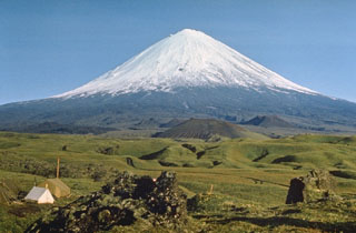
Geological Summary. Klyuchevskoy (also spelled Kliuchevskoi) is Kamchatka's highest and most active volcano. Since its origin about 6000 years ago, the beautifully symmetrical, 4835-m-high basaltic stratovolcano has produced frequent moderate-volume explosive and effusive eruptions without major periods of inactivity. It rises above a saddle NE of sharp-peaked Kamen volcano and lies SE of the broad Ushkovsky massif. More than 100 flank eruptions have occurred during the past roughly 3000 years, with most lateral craters and cones occurring along radial fissures between the unconfined NE-to-SE flanks of the conical volcano between 500 m and 3600 m elevation. The morphology of the 700-m-wide summit crater has been frequently modified by historical eruptions, which have been recorded since the late-17th century. Historical eruptions have originated primarily from the summit crater, but have also included numerous major explosive and effusive eruptions from flank craters.
Information Contacts: Olga A. Girina, Kamchatka Volcanic Eruptions Response Team (KVERT), a cooperative program of the Institute of Volcanic Geology and Geochemistry, Far East Division, Russian Academy of Sciences, Piip Ave. 9, Petropavlovsk-Kamchatsky, 683006, Russia, the Kamchatka Experimental and Methodical Seismological Department (KEMSD), GS RAS (Russia), and the Alaska Volcano Observatory (USA); Alaska Volcano Observatory (AVO), a cooperative program of the U.S. Geological Survey, 4200 University Drive, Anchorage, AK 99508-4667, USA (URL: http://www.avo.alaska.edu/), the Geophysical Institute, University of Alaska, PO Box 757320, Fairbanks, AK 99775-7320, USA, and the Alaska Division of Geological and Geophysical Surveys, 794 University Ave., Suite 200, Fairbanks, AK 99709, USA.