Report on Tengger Caldera (Indonesia) — May 2004
Bulletin of the Global Volcanism Network, vol. 29, no. 5 (May 2004)
Managing Editor: Richard Wunderman.
Tengger Caldera (Indonesia) Mount Bromo's 8 June eruption killed two and ejected a 3-km-high ash plume
Please cite this report as:
Global Volcanism Program, 2004. Report on Tengger Caldera (Indonesia) (Wunderman, R., ed.). Bulletin of the Global Volcanism Network, 29:5. Smithsonian Institution. https://doi.org/10.5479/si.GVP.BGVN200405-263310
Tengger Caldera
Indonesia
7.942°S, 112.95°E; summit elev. 2329 m
All times are local (unless otherwise noted)
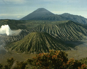
Reports of the Volcanological Survey of Indonesia (VSI) stated that Mount Bromo produced a phreatic eruption at 1526 on 8 June 2004. The eruption killed two people and injured several others. The Bromo cone is the youngest and most active volcano within the larger Tengger caldera complex. Bromo also resides within an inner caldera (Sandsea caldera).
The eruption, which vented at the crater, had a duration of ~20 minutes. Ash rose up to 3 km above the crater rim (figure 6) and was blown to the WNW and detected at the Mount (Gunung) Kelud observatory (~ 75 km away). Lapilli and ash spread out over a radius of ~ 300 m from the crater's center.
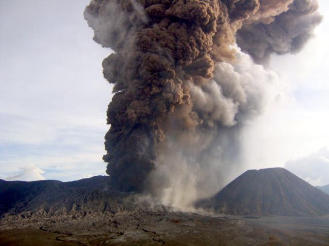 |
Figure 6. Bromo's 8 June 2004 eruption as seen 2.2 km away, looking from the N. The photographer, K. Nishi, was in the seismic station and saw evidence of the eruption on the seismic system. He ran to the adjacent crater rim and took a series of shots. This one was taken 9 minutes after the eruption began. The prominent cone on the right is Batok. Courtesy of K. Nishi. |
Bromo was closed to the public until further notice. Its hazard status was set to the elevated state of 'Alert Level III' (on a scale with a maximum of IV). Search and rescue teams were advised to stay away from the volcano until declaration of safe approach.
John Seach reported that many buildings in the nearby towns of Malang and Probolinggo were covered by a light coating of ash 2 hours after the eruption. The neighboring towns of Lumajang and Pasuruan were also affected by the eruption.
From 0600 on 9 June to 0600 on 10 June, visual observations disclosed a thin white and slightly red cloud about 25-50 m above the crater, moving W. Seismic records were dominated by tremor with peak-to-peak amplitudes ranging from ~ 1-4 mm. Seismometers also registered 123 emission earthquakes and 15 type-A volcanic earthquakes.
During 1800 on 10 June through 0600 on 11 June, the activity of Bromo was dominated by 'smoke emissions' of low-to-medium intensity reaching heights of ~ 25-100 m. Shallow volcanic earthquakes increased, and continuous tremor occurred with a peak-to-peak amplitude of 6.0 mm. Four volcanic earthquakes were detected within about 8-15 minutes, followed by tremor for 18 minutes, after which came 8 volcanic earthquakes. Despite all of the tremor and earthquakes, however, no explosion followed. When the weather was clear, VSI scientists could see white, thick 'smoke' emissions and smelled sulfur.
At 0819 on 14 June 2004, there was an ash explosion, accompanied by a plume that rose to 100 m. Pre-explosion spectrometer measurements suggested SO2 fluxes of 200 tons/day. During 13-14 June the seismic record contained emission and tectonic earthquakes, as well as a half hour of continuous tremor with a peak-to-peak amplitude of 6.0 mm. Deformation measurement using electronic distance meters (EDM) and global positioning systems (GPS) implied deflations of about 2-6 mm and 2-15 mm, respectively.
By 0630 on 15 June 2004, activity at Bromo had generally decreased, and the Alert Level was reduced to Level II. During that day emissions of white thin smoke rose ~ 25-150 m above the summit and the seismograph recorded 24 emission earthquakes and 1 tectonic earthquake. Deformation measured by EDM and GPS implied respective deflations of 1.0-5.0 mm and 0.2-6.2 mm.
Geological Summary. The 16-km-wide Tengger caldera is located at the northern end of a volcanic massif extending from Semeru volcano. The massive volcanic complex dates back to about 820,000 years ago and consists of five overlapping stratovolcanoes, each truncated by a caldera. Lava domes, pyroclastic cones, and a maar occupy the flanks of the massif. The Ngadisari caldera at the NE end of the complex formed about 150,000 years ago and is now drained through the Sapikerep valley. The most recent of the calderas is the 9 x 10 km wide Sandsea caldera at the SW end of the complex, which formed incrementally during the late Pleistocene and early Holocene. An overlapping cluster of post-caldera cones was constructed on the floor of the Sandsea caldera within the past several thousand years. The youngest of these is Bromo, one of Java's most active and most frequently visited volcanoes.
Information Contacts: Dali Ahmad, Volcanological Survey of Indonesia (VSI), Directorate of Volcanology and Geological Hazard Mitigation, Jalan Diponegoro No. 57, Bandung 40122, Indonesia (URL: http://www.vsi.esdm.go.id/); Heri Retnowate, Reuters; Derwin Pereira, The Straits Times; John Seach, P.O. Box 842, Southport BC 4215, Queensland, Australia (URL: http://www.volcanolive.com); Darwin Volcanic Ash Advisory Centre (VAAC), Bureau of Meteorology, Northern Territory Regional Office, PO Box 40050, Casuarina, NT 0811, Australia (URL: http://www.bom.gov.au/info/vaac/).