Report on Ulawun (Papua New Guinea) — June 2004
Bulletin of the Global Volcanism Network, vol. 29, no. 6 (June 2004)
Managing Editor: Richard Wunderman.
Ulawun (Papua New Guinea) No MODVOLC thermal anomalies detected despite other observed activity
Please cite this report as:
Global Volcanism Program, 2004. Report on Ulawun (Papua New Guinea) (Wunderman, R., ed.). Bulletin of the Global Volcanism Network, 29:6. Smithsonian Institution. https://doi.org/10.5479/si.GVP.BGVN200406-252120
Ulawun
Papua New Guinea
5.05°S, 151.33°E; summit elev. 2334 m
All times are local (unless otherwise noted)
No new activity was detected by MODVOLC as recently as mid-2004. This was the case despite reports of seismic activity and deflation during January-March 2003 (BGVN 28:03), as well as white vapor emissions and offshore effervescence (BGVN 28:09) and intermittent ash plumes during September-December 2003 (BGVN 28:11).
Data acquisition and analysis. Reports from Diego Coppola and David A. Rothery provided analyses of MODIS thermal alerts during 2001 and 2002 (using the MODVOLC alert-detection algorithm) extracted from the MODIS Thermal Alerts website (http://modis.hgip.hawaii.edu/) maintained by the University of Hawaii HIGP MODIS Thermal Alerts team (BGVN 28:01). Rothery and Charlotte Saunders provided updates to 31 May 2004. MODVOLC data are now routinely available from the Aqua satellite (equator crossing times 0230 and 1430 local time) in addition to the original Terra satellite (equator crossing times 1030 and 2230 local time).
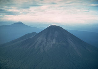
Geological Summary. The symmetrical basaltic-to-andesitic Ulawun stratovolcano is the highest volcano of the Bismarck arc, and one of Papua New Guinea's most frequently active. The volcano, also known as the Father, rises above the N coast of the island of New Britain across a low saddle NE of Bamus volcano, the South Son. The upper 1,000 m is unvegetated. A prominent E-W escarpment on the south may be the result of large-scale slumping. Satellitic cones occupy the NW and E flanks. A steep-walled valley cuts the NW side, and a flank lava-flow complex lies to the south of this valley. Historical eruptions date back to the beginning of the 18th century. Twentieth-century eruptions were mildly explosive until 1967, but after 1970 several larger eruptions produced lava flows and basaltic pyroclastic flows, greatly modifying the summit crater.
Information Contacts: David A. Rothery and Charlotte Saunders, Department of Earth Sciences, The Open University, Milton Keynes, MK7 6AA, United Kingdom.

