Report on Rabaul (Papua New Guinea) — June 2004

Bulletin of the Global Volcanism Network, vol. 29, no. 6 (June 2004)
Managing Editor: Richard Wunderman.
Rabaul (Papua New Guinea) Numerous MODVOLC thermal alerts during October 2003-January 2004
Please cite this report as:
Global Volcanism Program, 2004. Report on Rabaul (Papua New Guinea) (Wunderman, R., ed.). Bulletin of the Global Volcanism Network, 29:6. Smithsonian Institution. https://doi.org/10.5479/si.GVP.BGVN200406-252140
Rabaul
Papua New Guinea
4.2459°S, 152.1937°E; summit elev. 688 m
All times are local (unless otherwise noted)
MODVOLC alerts were still intermittent adjacent to the site of the Tavurvur cone up to the end of April 2003, with single alert pixels detected on 8 January, 31 March, and 30 April 2003 (figure 39). This was consistent with earlier reports of ground-based observations (BGVN 28:03 and 28:09), which described sub-continuous ash emissions for this period. Although there were frequent ash eruptions during March-October 2003 (BGVN 28:09), no alerts were generated by MODVOLC.
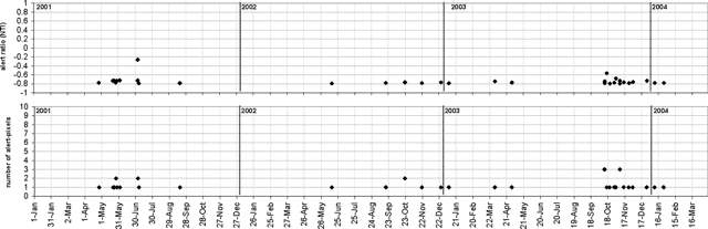 |
Figure 39. MODIS thermal alerts from Rabaul's Tavurvur cone seen during 1 January 2001-31 May 2004. Thermal alerts collated by Charlotte Saunders and David Rothery; data courtesy of the Hawaii Institute of Geophysics and Planetology's MODIS thermal alert team. |
MODVOLC detection started again on 12 October 2003, when three alert pixels were recorded. Alerts were numerous through October-December 2003, concluding with six single-pixel alerts, with the last occurring on 25 January 2004. The highest alert ratio was -0.57, seen on 16 October 2003, but most of the alerts for this period were just above the detection threshold. This was consistent with previously reported observations (BGVN 28:11), although there were no ground-based observational reports of higher activity for 12-16 October when the alerts appeared most intense.
Data acquisition and analysis. Reports from Diego Coppola and David A. Rothery provided analyses of MODIS thermal alerts during 2001 and 2002 (using the MODVOLC alert-detection algorithm) extracted from the MODIS Thermal Alerts website (http://modis.hgip.hawaii.edu/) maintained by the University of Hawaii HIGP MODIS Thermal Alerts team (BGVN 28:01). Rothery and Charlotte Saunders provided updates to 31 May 2004. MODVOLC data are now routinely available from the Aqua satellite (equator crossing times 0230 and 1430 local time) in addition to the original Terra satellite (equator crossing times 1030 and 2230 local time).
Geological Summary. The low-lying Rabaul caldera on the tip of the Gazelle Peninsula at the NE end of New Britain forms a broad sheltered harbor utilized by what was the island's largest city prior to a major eruption in 1994. The outer flanks of the asymmetrical shield volcano are formed by thick pyroclastic-flow deposits. The 8 x 14 km caldera is widely breached on the east, where its floor is flooded by Blanche Bay and was formed about 1,400 years ago. An earlier caldera-forming eruption about 7,100 years ago is thought to have originated from Tavui caldera, offshore to the north. Three small stratovolcanoes lie outside the N and NE caldera rims. Post-caldera eruptions built basaltic-to-dacitic pyroclastic cones on the caldera floor near the NE and W caldera walls. Several of these, including Vulcan cone, which was formed during a large eruption in 1878, have produced major explosive activity during historical time. A powerful explosive eruption in 1994 occurred simultaneously from Vulcan and Tavurvur volcanoes and forced the temporary abandonment of Rabaul city.
Information Contacts: David A. Rothery and Charlotte Saunders, Department of Earth Sciences, The Open University, Milton Keynes, MK7 6AA, United Kingdom.