Report on Tengger Caldera (Indonesia) — July 2004
Bulletin of the Global Volcanism Network, vol. 29, no. 7 (July 2004)
Managing Editor: Richard Wunderman.
Tengger Caldera (Indonesia) Video of the 8 June eruption; minor ash plumes through 18 July
Please cite this report as:
Global Volcanism Program, 2004. Report on Tengger Caldera (Indonesia) (Wunderman, R., ed.). Bulletin of the Global Volcanism Network, 29:7. Smithsonian Institution. https://doi.org/10.5479/si.GVP.BGVN200407-263310
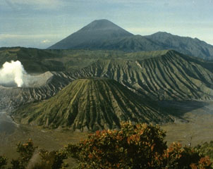
Tengger Caldera
Indonesia
7.942°S, 112.95°E; summit elev. 2329 m
All times are local (unless otherwise noted)
Mount Bromo's 8 June 2004 eruption killed two visitors and injured five more (BGVN 29:05). This report mainly adds a few details for the events of 8 June and a video of the eruption plume. It also summarizes reports through 18 July, an interval characterized by mild ash-bearing eruptions (to 100 m high) without a repeat of the robust eruption seen on 8 June.
A 3-minute-long video clip of the eruption was shot by Kiyoshi Nishi, a volcano seismologist attached to the Indonesian Directorate of Volcanology and Geological Hazard Mitigation (DVGHM). (DVGHM was reorganized from the former Volcanological Survey of Indonesia). Nishi works for the Japan International Cooperation Agency, a Japanese government organization offering technical and grant assistance.
The video begins after a substantial plume had already developed. The plume continued to rise, and the main body of it appeared to ascend with only minor effects of wind, rising in a roughly vertical direction. Identifiable zones of distinct coloration appeared within the plume, in shades of brown, reddish-brown, gray, and white. The white-gray zone, which clearly erupted earlier, moved away from the viewer. Most of the footage shows the brown and red parts of the plume evolving. Subsidiary clouds several times began bulging out of the main plume's margins. The image is valuable because of the need to accurately assess ash plume heights and behavior such as the rise time of the plume top, colored zones, and subsidiary clouds, and the absolute plume heights with respect to time.
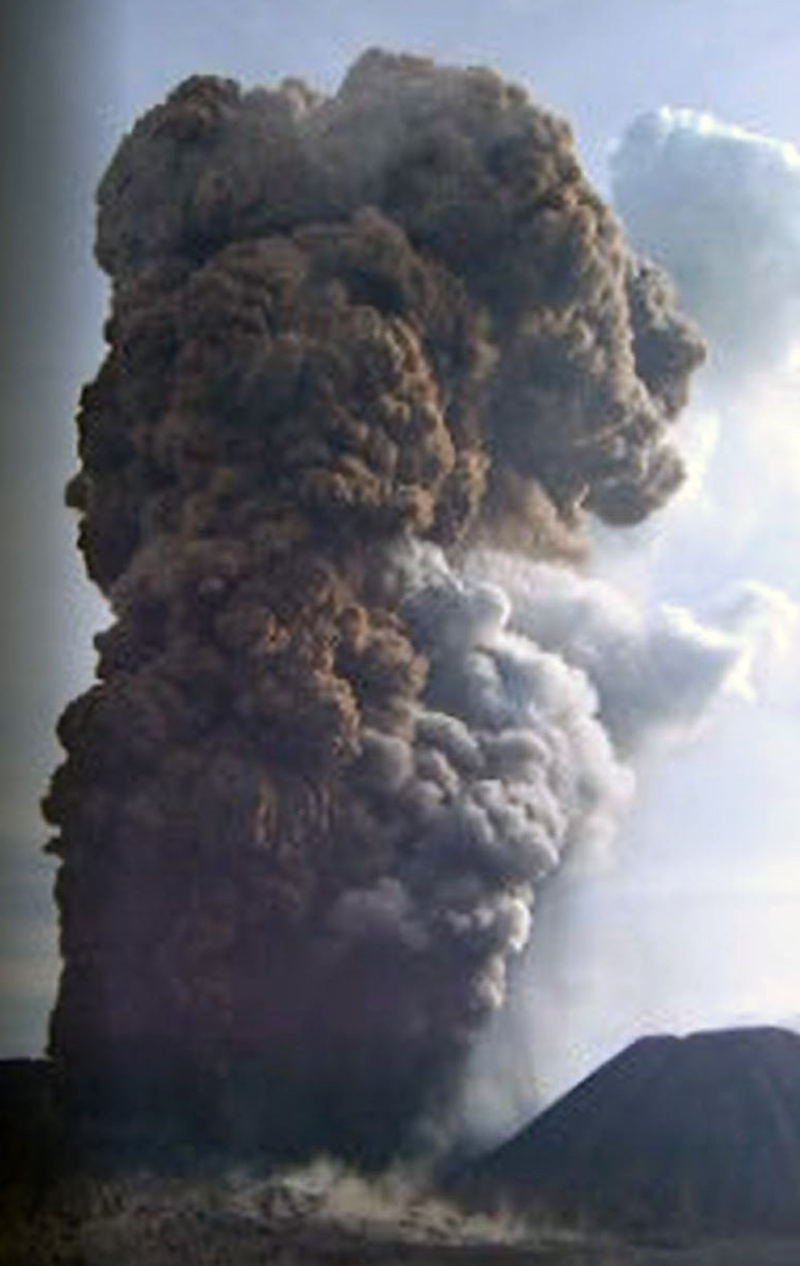 |
Movie 1. Video showing the Bromo eruption of 8 June 2004, taken looking from the NE, at a spot in the vicinity of the seismic station and ~ 2.2 km away from the eruptive vent on Bromo. The video (34.7 MB, 3.0-minute long AVI) began at 15 hours, 25 minutes, and 45 seconds; it was shot with a Canon IXY Digital 30 camera in movie mode at 15 frames/second. The same video was also featured on the VSI website. The video begins in 'landscape' format and later shifts to 'portrait' format. Courtesy of Kyoshi Nishi, JICA Silver Expert. |
Seismicity during 9-14 June was marked by long periods of continuous tremor (maximum peak-to-peak amplitude 6.0 mm), shallow type-A and type-B volcanic earthquakes, intermittent tectonic earthquakes, and a high number of emission earthquakes (see table 1 and BGVN 29:05 for details). Reports around this time noted that distance meters (EDM) and global positioning system (GPS) receivers on Bromo recorded deformation that suggested deflation of the edifice. On 14 June, Bromo ejected another ash plume that rose 100 m above the summit.
Table 1. Weekly seismicity at Bromo as measured by the Volcanological Survey of Indonesia (VSI) seismograph. Courtesy of VSI.
| Date | Volcanic Type A | Volcanic Type B | Tremor | Local Tectonic | Emission |
| 07 Jun-13 Jun 2004 | 26 | 15 | continuous | 0 | 387 |
| 14 Jun-20 Jun 2004 | 0 | 0 | 0 | 0 | 376 |
| 21 Jun-27 Jun 2004 | 15 | 0 | 3 | 3 | 163 |
| 28 Jun-04 Jul 2004 | 1 | 0 | 2 | 0 | 104 |
| 05 Jul-11 Jul 2004 | 2 | 0 | 2 | 3 | 116 |
| 12 Jul-18 Jul 2004 | 2 | 0 | 3 | 0 | 79 |
Nearly two weeks after the 8 June eruption, no similarly substantial event had occurred. On 15 June, DVGHM decreased the Alert Level to II, or 'eruption imminent.' Reports covering 14 June-18 July noted a decrease in seismically detected volcanic emissions (table 2). The number of emission earthquakes decreased by ~ 50% after 20 June and dropped again the week of 12-18 July. Bromo's emissions continued to bear ash, and during 14-27 June a thick ash plume rose 25-100 m above the crater rim. In accord with the decline in seismically detected emissions, observers noted smaller (25-50 m high), thinner plumes during 28 June-18 July.
Other seismicity also decreased (table 2). Seismometers recorded 15 type-A earthquakes during 21-27 June, but this was a peak in the trend for 14 June-18 July, which was generally 1-2 per week. Seismometers recorded no type-B earthquakes at Bromo since the week of its phreatic eruption. Tremor, continuous during 7-13 June, dropped to 2-3 events/week. Local tectonic earthquakes were intermittent.
Geological Summary. The 16-km-wide Tengger caldera is located at the northern end of a volcanic massif extending from Semeru volcano. The massive volcanic complex dates back to about 820,000 years ago and consists of five overlapping stratovolcanoes, each truncated by a caldera. Lava domes, pyroclastic cones, and a maar occupy the flanks of the massif. The Ngadisari caldera at the NE end of the complex formed about 150,000 years ago and is now drained through the Sapikerep valley. The most recent of the calderas is the 9 x 10 km wide Sandsea caldera at the SW end of the complex, which formed incrementally during the late Pleistocene and early Holocene. An overlapping cluster of post-caldera cones was constructed on the floor of the Sandsea caldera within the past several thousand years. The youngest of these is Bromo, one of Java's most active and most frequently visited volcanoes.
Information Contacts: Directorate of Volcanology and Geological Hazard Mitigation (DVGHM), Jalan Diponegoro No. 57, Bandung 40122, Indonesia (URL: http://www.vsi.esdm.go.id/); Darwin Volcanic Ash Advisory Centre (VAAC), Bureau of Meteorology, Northern Territory Regional Office, PO Box 40050, Casuarina, NT 0811, Australia (URL: http://www.bom.gov.au/info/vaac/); Kiyoshi Nishi, Japan International Cooperation Agency (JICA) (URL: https://www.jica.go.jp/).