Report on Popocatepetl (Mexico) — January 2005

Bulletin of the Global Volcanism Network, vol. 30, no. 1 (January 2005)
Managing Editor: Richard Wunderman.
Popocatepetl (Mexico) Relative quiet of 2004 ended during December 2004 and January 2005
Please cite this report as:
Global Volcanism Program, 2005. Report on Popocatepetl (Mexico) (Wunderman, R., ed.). Bulletin of the Global Volcanism Network, 30:1. Smithsonian Institution. https://doi.org/10.5479/si.GVP.BGVN200501-341090
Popocatepetl
Mexico
19.023°N, 98.622°W; summit elev. 5393 m
All times are local (unless otherwise noted)
During 2004, Popocatépetl showed an overall low level of activity. Apart from a few low-intensity exhalations, no significant seismicity, deformation, or geochemical changes in spring waters were detected. The crater (figure 49) did not show significant morphological changes other than hydrologic effects, and no evidence of lava dome emplacements were observed. During December, relatively low-level volcanism prevailed, including low-intensity steam-and-gas emissions (table 15). An aerial photograph taken on 10 December showed subsidence in the inner crater and no external lava dome at the bottom of the crater. The Alert Level remained at Yellow Phase II.
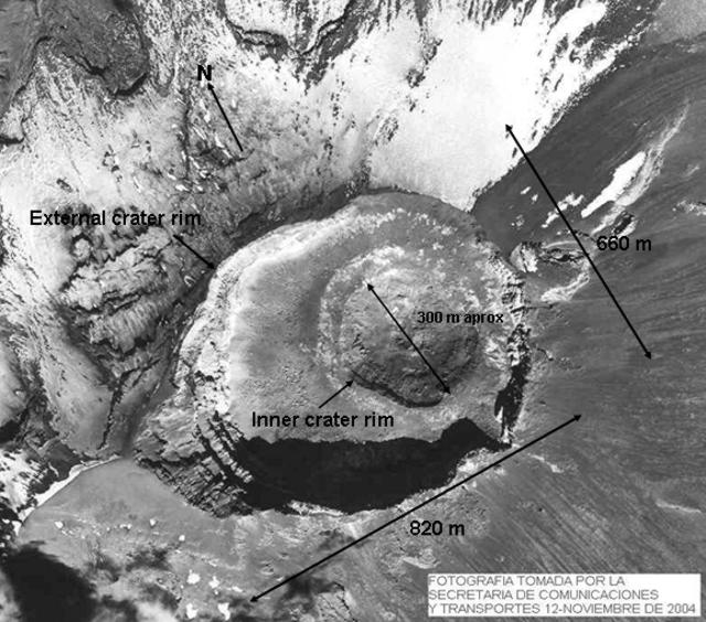 |
Figure 49. Annotated aerial photograph of Popocatepétl's summit area taken 12 November 2004. Courtesy of CENAPRED; the Mexican Secretary of Communications and Transportation; and Servando De la Cruz, UNAM. |
Table 15. Summary of various observations at Popocatépetl during December 2004 (chiefly visual confirmations of ongoing emission). Courtesy of CENAPRED.
| Date | Exhalations | Other Observations |
| 01 Dec-04 Dec 2004 | Low-intensity (9-13 per day) | Light steam-and-gas emissions |
| 05 Dec-07 Dec 2004 | Low-intensity (16-19 per day) | Light steam-and-gas emissions |
| 08 Dec-09 Dec 2004 | Low-intensity (7-10 per day) | Light steam-and-gas emissions |
| 10 Dec 2004 | Low-intensity (11) | Aerial photograph showed subsidence in the inner crater; no external lava dome at the bottom of the crater can be distinguished |
| 11 Dec-16 Dec 2004 | Low-intensity (3-10 per day) | Light steam-and-gas emissions |
| 17 Dec-21 Dec 2004 | Low-intensity (2-5 per day) | Light steam-and-gas emissions |
| 22 Dec-27 Dec 2004 | Low intensity (6-10 per day) | Light steam-and-gas emissions |
| 28 Dec 2004 | Low-intensity (19) | Light steam-and-gas emissions |
| 29 Dec-31 Dec 2004 | Low-intensity (9-11 per day) | Light steam-and-gas emissions |
At the end of December 2004, however, a slight increase in seismic activity was detected (table 15). On 20 and 29 December 2004 two exhalations, small yet exceeding the average for the year, were followed in early January 2005 by a series of phreatic explosions. The major events were detected on 9 January at 2245 and on 22 January at 2358. These were the largest events detected in the past 15 months. In both cases, light ashfall was reported on the towns of Cuautla (< 40 km SSW of the volcano), and San Martín Texmelucan (37 km NE of the crater). In an aerial photograph taken on 14 January 2005 the inner crater appears deeper than previously shown, with no evidence of magmatic activity (figure 50).
 |
Figure 50. Annotated photograph of Popocatépetl's summit area taken 14 January 2005. A label identifies a small craterlet on the southern inner wall of the inner crater. These type of craterlets have been repeatedly formed by moderate explosions or exhalations. They have tended to be ephemeral, lasting only until the next event. Courtesy of CENAPRED; the Mexican Secretary of Communications and Transportation; and Servando De la Cruz, UNAM. |
Geological Summary. Volcán Popocatépetl, whose name is the Aztec word for smoking mountain, rises 70 km SE of Mexico City to form North America's 2nd-highest volcano. The glacier-clad stratovolcano contains a steep-walled, 400 x 600 m wide crater. The generally symmetrical volcano is modified by the sharp-peaked Ventorrillo on the NW, a remnant of an earlier volcano. At least three previous major cones were destroyed by gravitational failure during the Pleistocene, producing massive debris-avalanche deposits covering broad areas to the south. The modern volcano was constructed south of the late-Pleistocene to Holocene El Fraile cone. Three major Plinian eruptions, the most recent of which took place about 800 CE, have occurred since the mid-Holocene, accompanied by pyroclastic flows and voluminous lahars that swept basins below the volcano. Frequent historical eruptions, first recorded in Aztec codices, have occurred since Pre-Columbian time.
Information Contacts: Alicia Martinez Bringas, Angel Gómez Vázquez, Roberto Quass Weppen, Enrique Guevara Ortiz, Gilberto Castelan Pescina, and Cesar Morquecho Zamarripa, Centro Nacional de Prevención de Desastres (CENAPRED), Av. Delfín Madrigal No.665. Coyoacan, México D.F. 04360 (URL: https://www.gob.mx/cenapred/); Servando De la Cruz-Reyna, Instituto de Geofísica, UNAM Cd. Universitaria. Circuito Institutos, Coyoácan, D.F. 04510, México (URL: http://www.geofisica.unam.mx).