Report on Galeras (Colombia) — September 2005

Bulletin of the Global Volcanism Network, vol. 30, no. 9 (September 2005)
Managing Editor: Richard Wunderman.
Galeras (Colombia) Hazard graphics; vigorous 2004 eruptions generally quieting thus far in 2005
Please cite this report as:
Global Volcanism Program, 2005. Report on Galeras (Colombia) (Wunderman, R., ed.). Bulletin of the Global Volcanism Network, 30:9. Smithsonian Institution. https://doi.org/10.5479/si.GVP.BGVN200509-351080
Galeras
Colombia
1.22°N, 77.37°W; summit elev. 4276 m
All times are local (unless otherwise noted)
In a meeting abstract Gomez and others (2004) wrote, "Following 11 years of relatively low activity, Galeras . . . produced a sequence of ash eruptions in July and August 2004. . .. Initial evidence of the activity transition appeared in the gas measurements [of] early June, followed by a strong increase in the shallow seismic activity below the active cone on 27 June. As in many cases at other volcanoes, the most clear evidence for the transition came in the form of seismic swarms and tremor. The current activity has culminated in two brief episodes of ash emission, on 16 July and 21 July, followed by two longer episodes, [during] 27 July-8 August and 11-19 August. This last episode began with a large explosion and released more ash than any individual episode from 1989 to 1993. Sudden deformation, as well as changes in the electric and magnetic [EM] fields at the crater EM station, and [in] gas parameters such as CO2 concentration and fumarole temperature accompanied the [16 and 21 July] ash emissions. Unfortunately, the EM and gas instruments were lost to ashfall shortly afterward."
The same abstract also noted that "Starting in March 1996, a multiparameter real-time monitoring system was installed at Galeras, as a part of a cooperative program between INGEOMINAS [Instituto Colombiano de Geología y Minería] (Colombia) and the BGR [Bundesanstalt f?r Geowissenschaften und Rohstoffe] (Germany). Broadband seismometers were installed first, with electromagnetic (EM) sensors, sensors for the chemistry and physics of the fumarole gases, and a weather station following later. The data from these instruments augment the short-period seismic network and tiltmeters of Observatorio Vulcanológico de Pasto (OVP). Additional spot measurements [relied upon] visual inspection from the ground or helicopter, a thermal camera[,] and regular geological forays onto Galeras' slopes."
Our previous report covered events through late July 2004 (BGVN 29:07); this report discusses events through mid-October 2005. Besides the eruptions of July through August 2004, another month with vigorous activity was November 2004. A sudden explosion on 21 November drove a plume to 9-10 km altitude. The latter portion of this report interval (June to mid-October 2005) typically involved ongoing though diminished intensity of volcanism and seismicity.
In response to the crisis, authorities produced engaging graphics, reminiscent of landscape paintings, but also containing risk assessments (figures 108 and 109), in the originals as color-coded lines. These graphics accompanied explanatory text. The authorities also produced a colorful poster. In addition, articles on Galeras hazards appeared in local papers, many along with clear graphics. The distance from the summit to central Pasto is only ~ 9 km.
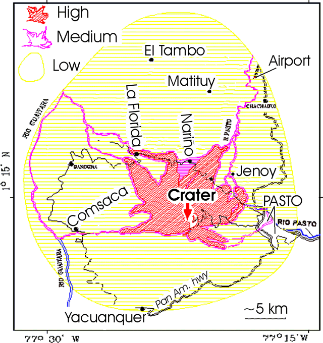 |
Figure 108. A hazards map prepared for Galeras. The key (upper left) shows symbols for risk zones (high, medium, and low). The settlement Genoy is also spelled Jenoy. This map is slightly modified from one by Observatorio Vulcanológico y Sismológico de Pasto, INGEOMINAS. |
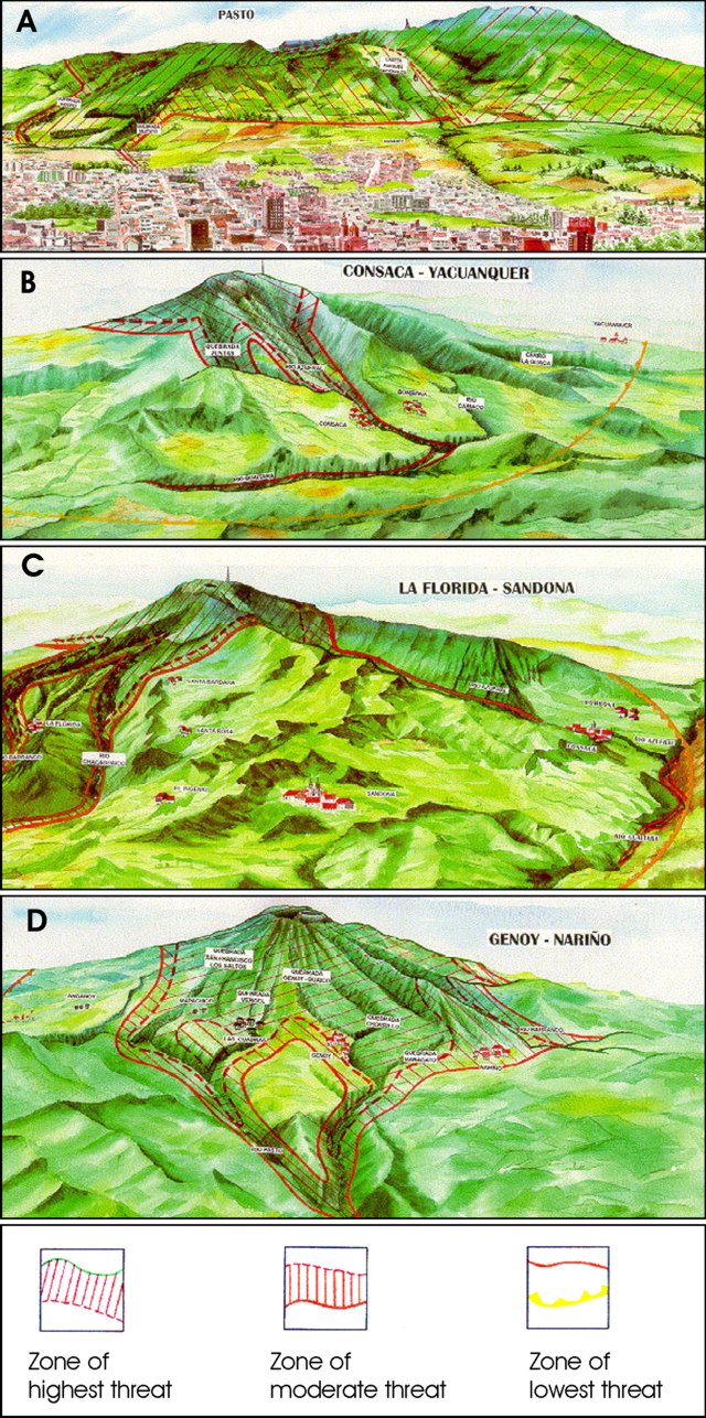 |
Figure 109. A sample of Galeras hazards graphics available during the 2004-2005 crisis. Galeras and surroundings appear in a series of perspectives that also illustrate likely paths of destructive processes. The artwork emphasizes important geography, labels many settlements, and portrays familiar buildings and skylines. Hazard zones are shown by symbols (see key at the bottom). Views are as follows: A: NW-looking view (S-SE flanks, "Pasto"), B: NE-looking view (SW flanks, "Consaca-Yacuanquer"), C: SE-looking view, (NW flanks, "La Florida-Sandona"), and D: SW-looking view, (NE flanks, "Genoy-Nariño"). Copyrighted images courtesy of Observatorio Vulcanológico y Sismológico de Pasto, INGEOMINAS. |
July-December 2004. INGEOMINAS noted that the July 2004 emissions came from El Pinta crater and from Deformes fumarolic field. Field observations on 19 July disclosed ash freshly vented from El Pinta crater, forming a deposit that ranged in thickness from 3 mm at the base of the cone to ~ 20 cm near the point of emission.
During the latter half of July 2004 INGEOMINAS noted that emissions rose ~ 600 m above the volcano's summit. Ash was not then visible on satellite imagery. On 21 July 2004 a seismic signal corresponded with a visible plume rising ~ 500 m above the volcano and seen from Pasto. According to a news report, a wide area around the volcano had been declared off limits to visitors. Several higher plumes followed.
According to the Washington VAAC, several ash plumes emitted were visible on satellite imagery during 7-10 August 2004. The highest rising plume reached ~ 6 km altitude.
INGEOMINAS reported that on 11 August at 2349 an eruption sent an ash-and-gas cloud to an unknown height and generated visible incandescence. According to the Washington VAAC, satellite imagery showed an ash plume that rose to ~ 10.7 km altitude. This plume spread in all directions, but mainly to the NE, E, and SW. Later, a thin plume reached a height of ~ 7.3 km altitude and drifted SW into northern Ecuador. A distinctly separate plume also occurred, drifting NW at an altitude of ~ 6.1 km.
Figure 110 shows a graphical depiction of the two plumes issued by the Washington VAAC, which incorporated GOES-12 satellite imagery as part of an advisory sent out at 0807 on 12 August 2004. The observations were from about an hour earlier. This following message was in the 'remarks' part of the advisory."Ash heading [NE] earlier in the night can no longer be seen in satellite imagery. A faint plume of ash is heading SW into northern Ecuador but is slowly becoming diffused in satellite imagery. The ash heading SW is estimated to FL240 [~ 7.3 km altitude]. An ash plume moving NW from the summit is estimated to FL200 [~ 6.1 km altitude]. We will continue to closely monitor and advise earlier than normal if needed."
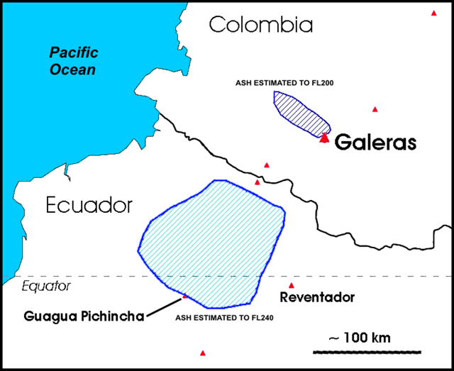 |
Figure 110. The Galeras ash plumes were distributed in a Volcanic Ash Advisory (VAA) issued at 1307 UTC on 12 August 2004. When this image was taken at 1215 UTC, the two visible plumes had separated widely; one lingering slightly N of the volcano, the other, larger, reached a higher altitude and drifted over Ecuador. Plume top altitude estimates were 'flight level' (FL) 200 and 240, equivalent to 20,000 and 24,000 feet, ~ 6.1 and ~ 7.3 km altitude. Information sources listed included the GUAYAQUIL Meteorological Watch Office (MWO) and the GOES-12 satellite. (This VAA was issued under the header FVXX20 KNES 121307). Courtesy of the Washington VAAC; analysis by Jamie Kibler. |
The next advisory noted that ash had ceased to be visible in the imagery after 0715 (1215 UTC) on 12 August 2004 (in other words, after the image associated with the graphic in figure 110).
Fine ash from the 11 August eruption was deposited in villages near the volcano, including La Florida (~ 10 km NW of the volcano), Nariño, Sandoná, and Consacá, and farther afield in Ancuya, Linares, and Sotomayor (~ 40 km NW of the volcano). News articles reported that during these episodes ~ 230 families were evacuated, mainly from the volcano's N flank. The village of La Florida on the volcano's NW flank was most strongly impacted by the eruption. Ash contaminated potable water in some villages, impacted farm animal's health, and left hundreds of dead fish floating in rivers. On 16 August, ash emissions continued, depositing ash in several villages.
INGEOMINAS reported that gas-and-ash emissions continued at Galeras as of 18 August. Ash fell in villages near the volcano, including La Florida, Sandoná, El Ingenio (within 15 km of the volcano), and farther afield in Samaniego and Sotomayor (between 20 and 40 km from the volcano). During 19 August to 1 September, there was a decrease in the level of seismicity and the number of ash emissions. But, gas-and-steam emissions continued.
During September 2004, tremor associated with ash-and-gas emissions was recorded at Galeras. On the 23rd, ash deposits were seen on the upper N flank. By the 27th, the amount of tremor had decreased significantly, a change that coincided with a decrease in ash emissions. During most of October 2004, emissions of gas and fine ash continued at Galeras. Plumes rose to a maximum height of ~ 1.5 km above the volcano. Instruments recorded small-amplitude tremor associated with gas-and-ash emissions.
INGEOMINAS reported that at 1544 on 21 November 2004 Galeras erupted explosively. A resulting shock wave was felt as far away as Cimarrones (18 km N of the volcano), Chachagui (17 km N of the volcano), and Laguna de La Cocha (20 km SW of the volcano). Effects of the shock wave varied from a loud roar, to the vibration of large windows, to the vibrating sensation of an earthquake. Hot ballistic blocks fell nearly 3 km from the volcano on its eastern flank, producing short-lived forest fires. The eruption produced an ash-and-gas column that rose to an estimated 9-10 km altitude and drifted to the S and W. The Washington VAAC reported that satellite imagery of 21 November at 1815 (i.e., 22 November at 0015 UTC) revealed two separate plumes, a situation somewhat analogous to 11-12 August (figure 110). One set of plumes from the 21 November eruption were estimated to reach 9 km altitude, and they blew to the W. Other plumes interpreted as low-level ash were estimated to be near 4-5 km altitude; these remained in the vicinity of the volcano and showed little motion.
January-September 2005. During January 2005, low-level relatively shallow seismicity continued, and a small amount of deformation towards the W portion of the volcanic cone occurred. On 30 January an emission of gas and ash rose ~ 800 m above the volcano. During the first week of February 2005, small gas-and-ash emissions continued. Ash was deposited in the sectors of Consacá (~ 15 km W of the volcano) and La Florida, and in the city of Pasto (~ 10 km E). Low-level seismicity and a small amount of deformation were recorded.
According to a news article, on 24 May 2005 the Colombian government ordered the evacuation of ~ 9,000 people living near Galeras due to an increase in volcanic activity. INGEOMINAS reported that during 16-23 May, small shallow earthquakes occurred beneath the volcano. Earthquakes believed associated with fracturing within the volcano increased during the night of 21 May to the morning of 22 May. Deformation continued to be recorded at the volcano's summit. There were no ash emissions. Galeras remained at alert level II ('probable eruption in terms of days or weeks') as it has since 19 April 2005.
During early June 2005, seismicity and deformation decreased in comparison to the previous week. On 6 June the alert level was decreased from II to III ('changes in the behavior of volcanic activity have been noted'). During July and August 2005, seismicity chiefly remained low. One exception, a M 2.5 volcano-tectonic earthquake on 4 July 2005, was felt in sections of some towns near the volcano. Generally, observers also noted small amounts of deformation and low rates of gas discharge, with continued emissions from the main and secondary craters. Thirty volcano-tectonic earthquakes were recorded at Galeras during 19-21 August 2005. The earthquakes occurred 3-4 km NW of the volcano's active cone, near the towns of Santa Bárbara, Nariño, and La Florida. About five earthquakes felt by nearby populations occurred at depths of 6-8 km, with the largest (M 4.7) occurring at a depth of 6 km on 21 August.
During September 2005, minor seismicity and minor deformation continued. Seismic signals included 365 minor events near the volcano at less than 6 km depth. The larger September record consisted of 179 volcano-tectonic events, 291 long-period events, 258 hybrid events, and 96 tremor episodes. Some of these earthquakes correlated with gas and fine ash discharges. Flyovers at the end of September confirmed that gas emissions were significantly reduced compared to August 2005.
October INGEOMINAS reports noted occasional steam plumes visible from Pasto, often correlated with and presumably related to increases in rainfall and infiltration of water into hot portions of the volcano. A 5 October 2005 overflight revealed a small increase in gas emissions compared to similar flights during September 2005. Seismicity fluctuated and some instrumentally measured deformation continued.
Reference. Gomez, D., Hellweg, M., Buttkus, B., Boker, F., Calvache, M. L., Cortes, Faber, E., Gil Cruz, F., Greinwald, S., Laverde, C , Narváez, L., Ortega, A., Rademacher, H., Sandmann, Seidl, D., Silva, B., and Torres, R., 2004, A Volcano Reawakens: Multiparameter Observations of Activity Transition at Galeras Volcano (Colombia), Transactions, American Geophysical Union, Fall meeting (session entitled "Sources of Oscillatory Phenomena in Volcanic Systems I; Posters"), December 2004, San Francisco, CA
Geological Summary. Galeras, a stratovolcano with a large breached caldera located immediately west of the city of Pasto, is one of Colombia's most frequently active volcanoes. The dominantly andesitic complex has been active for more than 1 million years, and two major caldera collapse eruptions took place during the late Pleistocene. Long-term extensive hydrothermal alteration has contributed to large-scale edifice collapse on at least three occasions, producing debris avalanches that swept to the west and left a large open caldera inside which the modern cone has been constructed. Major explosive eruptions since the mid-Holocene have produced widespread tephra deposits and pyroclastic flows that swept all but the southern flanks. A central cone slightly lower than the caldera rim has been the site of numerous small-to-moderate eruptions since the time of the Spanish conquistadors.
Information Contacts: Diego Gomez Martinez, Observatorio Vulcanológico y Sismológico de Pasto (OVSP), INGEOMINAS, Carrera 31, 1807 Parque Infantil, PO Box 1795, Pasto, Colombia (URL: https://www2.sgc.gov.co/volcanes/index.html; Washington Volcanic Ash Advisory Center (VAAC), Satellite Analysis Branch (SAB), NOAA/NESDIS E/SP23, NOAA Science Center Room 401, 5200 Auth Road, Camp Springs, MD 20746, USA (URL: http://www.ospo.noaa.gov/Products/atmosphere/vaac/); El Spectador; El Pais (URL: http://elpais-cali.terra.com.co/paisonline/); Reuters.