Report on Sangay (Ecuador) — April 2006

Bulletin of the Global Volcanism Network, vol. 31, no. 4 (April 2006)
Managing Editor: Richard Wunderman.
Sangay (Ecuador) Some conspicuous plumes during 2004-2005; climber's photos from January 2006
Please cite this report as:
Global Volcanism Program, 2006. Report on Sangay (Ecuador) (Wunderman, R., ed.). Bulletin of the Global Volcanism Network, 31:4. Smithsonian Institution. https://doi.org/10.5479/si.GVP.BGVN200604-352090
Sangay
Ecuador
2.005°S, 78.341°W; summit elev. 5286 m
All times are local (unless otherwise noted)
Our previous report was in 1996 (BGVN 21:03); this report covers the time interval January 2004 to January 2006. According to a 2004 annual summary on the Instituto Geofísico (IG) website, Sangay was one of the most active volcanoes in Ecuador, and has been in eruption for ~ 80 years. Its isolated location (figure 6) has meant it has been thought of as a relatively small hazard risk. For this reason, monitoring has been less than for other Ecuadorian volcanoes. Thermal, visual, and satellite monitoring during 2002-2004 confirmed the central crater as the source of frequent explosions and continuing steam-and-gas emissions.
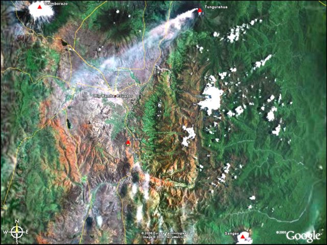 |
Figure 6. Satellite imagery showing the region around the city of Riobamba (center) in Ecuador), including Sangay (lower right), Chimborazo (upper left), Tungurahua (upper right), and Licto (center) volcanoes. An eruption plume can be discerned coming from Tungurahua, but the date of the image is unknown. The city of Riobamba is about 50 km NW of Sangay. Courtesy of Google Earth. |
During 2004 observers did not see lava flows or pyroclastic flows. An abnormally large eruption cloud was detected on 14 January 2004; it contained dominantly steam and gases, with minor ash content. Although only clearly detected and reported then, such events are thought to occur with considerable frequency.
Ramon and others (2006) summarized Sangay's activity as continuously erupting since 1934. Thermal images taken during the last three years showed that only one of the three summit craters was active and documented a lack of new, visible lava flows.
On 14 January 2004 a plume from Sangay was observed around 0500. The plume extended about 45 km E and most likely contained ash. During this time a hotspot was also visible on the satellite imagery. On 27 January 2004 a narrow ash plume emitted by Sangay rose to 6 km altitude and drifted SW.
On 1 May 2004, based on a pilot's report, the Washington VAAC noted that ash from an eruption at Sangay produced a plume to a height of ~ 6 km altitude at 1750. Ash was not visible on satellite imagery.
On 28 December 2004 around 0715 a plume from Sangay, most likely composed of steam with little ash, was detected. The plume was E of the volcano's summit at a height of ~ 6.4 km altitude. A hotspot was prominent on satellite imagery, but ash was more difficult to distinguish.
On 16 October 2005 around 0645 Sangay emitted an ash plume. The plume moved SSW very slowly, corresponding to a possible height of ~ 6.7 km altitude. By 0900 the plume was too thin to be visible on satellite imagery and thunderstorms developed in the area, further obscuring the ash cloud. Based on information from the IG, on 26 October 2005 the Washington VAAC noted that ash was seen over Sangay at 0758. No ash was visible on satellite imagery.
Climber's photo journal. Climbers Thorsten Boeckel and Martin Rietze created a website briefly describing a trek to Sangay's summit during 4-12 January 2006. Several of their posted photos from that trip appear here (figures 7-10; unfortunately, the photos, which are strikingly beautiful, were generally presented without much geographic context). The team included at least one local guide and was aided by horses. Settlements on the approach and return included the mountain village St. Eduardo, which they described as ~ 50 km S of Riobamba.
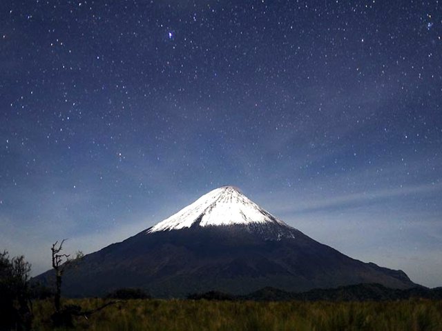 |
Figure 7. A vista of Sangay at nightfall in early January 2006. Direction of view is approximately WNW. Photo credit to Boeckel and Rietze. |
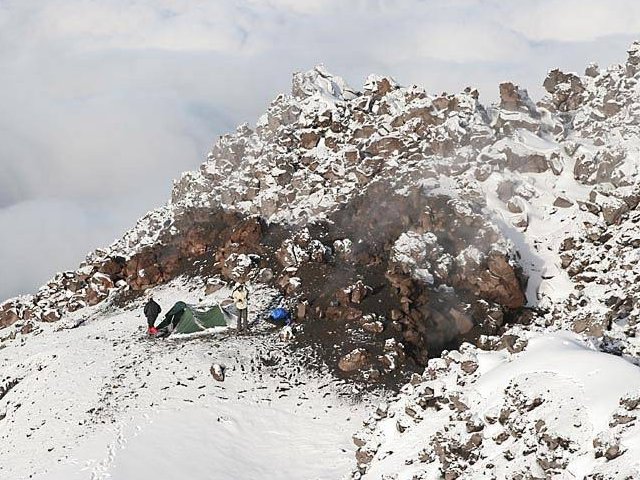 |
Figure 8. Photograph documenting the climbers tent camp high on the snowbound slopes of Sangay during their descent. Exact location on Sangay unknown; this was labeled "day 4/5," and should correspond to 7 or 8 January 2006. Photo credit to Boeckel and Rietze. |
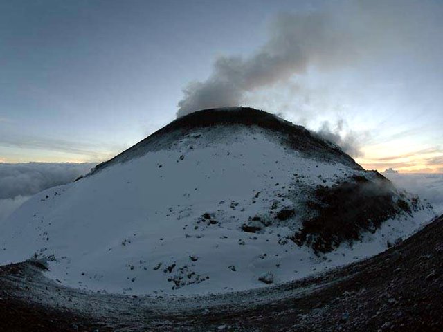 |
Figure 9. A topographic high forming part of the Sangay structure, gently steaming, apparently seen from the summit. This corresponds to 7 or 8 January 2006. Photo credit to Boeckel and Rietze. |
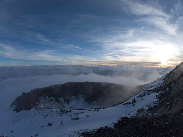 |
Figure 10. A crater on Sangay as seen by the climbers from the summit or upper flanks, described by them as the "snow covered east crater." This photo corresponds to 7 or 8 January 2006. Photo credit to Boeckel and Rietze. |
Except for some degassing, the group saw no other activity. Although local residents indicated that the last eruption had occurred about 2 months prior to their visit, intermittent eruptions pose hazards to climbers; in 1976 two climbers were killed by explosions from Sangay (SEAN 01:10).
Reference. Ramón, P., Rivero, D., Böker, F., and Yepes, H., 2006, Thermal monitoring using a portable IR camera: results on Ecuadorian volcanoes in "Cities on Volcanoes IV"; 23-27 January 2006.
Geological Summary. The isolated Sangay volcano, located east of the Andean crest, is the southernmost of Ecuador's volcanoes and its most active. The steep-sided, glacier-covered, dominantly andesitic volcano grew within the open calderas of two previous edifices which were destroyed by collapse to the east, producing large debris avalanches that reached the Amazonian lowlands. The modern edifice dates back to at least 14,000 years ago. It towers above the tropical jungle on the east side; on the other sides flat plains of ash have been eroded by heavy rains into steep-walled canyons up to 600 m deep. The earliest report of an eruption was in 1628. Almost continuous eruptions were reported from 1728 until 1916, and again from 1934 to the present. The almost constant activity has caused frequent changes to the morphology of the summit crater complex.
Information Contacts: P. Ramón, Instituto Geofísico-Departamento de Geofísica (IG), Escuela Politécnica Nacional, Casilla 17-01-2759, Quito, Ecuador; Washington Volcanic Ash Advisory Center (VAAC), Satellite Analysis Branch (SAB), NOAA/NESDIS E/SP23, NOAA Science Center Room 401, 5200 Auth Rd, Camp Springs, MD 20746, USA (URL: http://www.ospo.noaa.gov/Products/atmosphere/vaac/); Thorsten Boeckel and Martin Rietze, c/o Kermarstr.10, Germerswang, D-82216, Germany (URL: http://www.tboeckel.de/).