Report on Cleveland (United States) — July 2006
Bulletin of the Global Volcanism Network, vol. 31, no. 7 (July 2006)
Managing Editor: Richard Wunderman.
Cleveland (United States) Astronauts capture photo of 23 May eruption
Please cite this report as:
Global Volcanism Program, 2006. Report on Cleveland (United States) (Wunderman, R., ed.). Bulletin of the Global Volcanism Network, 31:7. Smithsonian Institution. https://doi.org/10.5479/si.GVP.BGVN200607-311240
Cleveland
United States
52.825°N, 169.944°W; summit elev. 1730 m
All times are local (unless otherwise noted)
On 23 May 2006, the Alaska Volcano Observatory (AVO) received a report from the International Space Station indicating that a plume was observed moving W from Cleveland volcano at 2300 UTC (BGVN 31:06). A photograph of the plume taken from the International Space Station was released by the National Aeronautics and Space Administration (NASA) (figure 5).
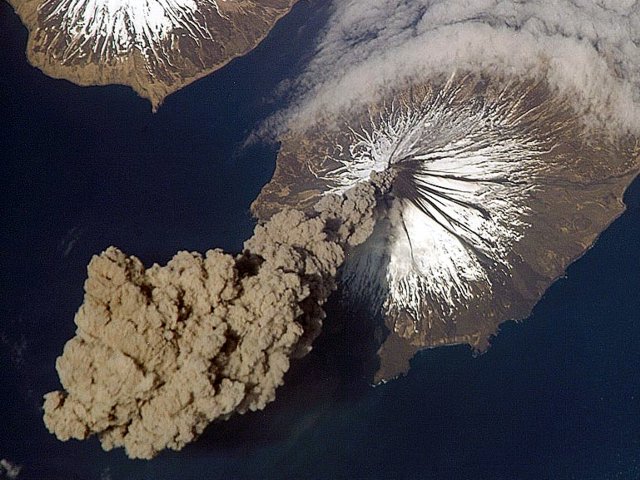 |
Figure 5. Eruption of Mount Cleveland on 23 May 2006 as photographed from the International Space Station at an orbital altitude of ~ 400 km. The photograph (N at the top; Carlisle Island to the NW) shows the ash plume moving SW from the summit. Banks of fog (arcuate clouds at upper right) are common features around the Aleutian Islands. The event proved to be short-lived; ~ 2 hours later, the plume had completely detached from the volcano. Courtesy of Jeffrey N. Williams, Flight Engineer and NASA Science Officer, International Space Station Expedition 13 Crew, NASA Earth Observatory. |
Starting at about 2300 UTC, just before this image was taken, Cleveland underwent a short eruption. The volcanic plume was seen in Advanced Very High Resolution Radiometer (AVHRR) polar-orbiting satellite data beginning from 2307 UTC. By 0100 UTC on 24 May the ash plume had detached from the vent and was approximately 130 kilometers SW of the volcano. Satellite data showed a cloud height of about 6.1 km asl (table 1). The plume was no longer detectable in satellite imagery by 0057 UTC on 25 May. In response to the event, AVO raised the Level of Concern Color Code to 'Yellow.'
Table 1. Satellite observations of ash plume from Cleveland volcano. Courtesy of the Washington Volcanic Ash Advisory Center (VAAC).
| Date and Time (UTC) | Plume altitude | Direction and speed |
| 24 May 2006 (0200) | 8.2 km | SW at 55 km/hour |
| 24 May 2006 (0800) | 6.7 km | SW at 37-46 km/hour |
| 24 May 2006 (1400) | 6.1 km | W at 37-46 km/hour |
The last eruption of Cleveland was 6 February 2006 (BGVN 31:01). Since 24 May 2006, no new information about ash emissions had been received, nor have indications of continuing activity been detected from satellite data for the volcano. This short-lived event was typical of recent Cleveland activity. On 7 August 2006, AVO downgraded the Level of Concern Color Code for Cleveland from 'Yellow' to 'Not Assigned." Because Cleveland is not monitored with real-time seismic instrumentation, during intervals of repose it does not receive an assignment of Color Code 'Green,' but instead is left 'Not Assigned.'
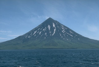
Geological Summary. The beautifully symmetrical Mount Cleveland stratovolcano is situated at the western end of the uninhabited Chuginadak Island. It lies SE across Carlisle Pass strait from Carlisle volcano and NE across Chuginadak Pass strait from Herbert volcano. Joined to the rest of Chuginadak Island by a low isthmus, Cleveland is the highest of the Islands of the Four Mountains group and is one of the most active of the Aleutian Islands. The native name, Chuginadak, refers to the Aleut goddess of fire, who was thought to reside on the volcano. Numerous large lava flows descend the steep-sided flanks. It is possible that some 18th-to-19th century eruptions attributed to Carlisle should be ascribed to Cleveland (Miller et al., 1998). In 1944 it produced the only known fatality from an Aleutian eruption. Recent eruptions have been characterized by short-lived explosive ash emissions, at times accompanied by lava fountaining and lava flows down the flanks.
Information Contacts: National Aeronautics and Space Administration (NASA) Earth Observatory (URL: http://earthobservatory.nasa.gov/); Washington Volcanic Ash Advisory Center (VAAC) (URL: http://www.ospo.noaa.gov/Products/atmosphere/vaac/); Jeffery Williams, NASA, ISS Crew Earth Observations and the Image Science & Analysis Group, Johnson Space Center 2101 NASA Parkway, Houston, TX 77058, USA.