Report on Dukono (Indonesia) — January 2007

Bulletin of the Global Volcanism Network, vol. 32, no. 1 (January 2007)
Managing Editor: Richard Wunderman.
Dukono (Indonesia) Inferred ash plume on 5 December 2006
Please cite this report as:
Global Volcanism Program, 2007. Report on Dukono (Indonesia) (Wunderman, R., ed.). Bulletin of the Global Volcanism Network, 32:1. Smithsonian Institution. https://doi.org/10.5479/si.GVP.BGVN200701-268010
Dukono
Indonesia
1.6992°N, 127.8783°E; summit elev. 1273 m
All times are local (unless otherwise noted)
Situated on Halmahera Island in northern Indonesia, Dukono released an ash plume 5 December 2006. The Moderate Resolution Imaging Spectroradiometer (MODIS) flying onboard NASA's Terra satellite captured the 5 December plume (figure 3) drifting E away from meteorological clouds. NASA affiliate Jesse Allen has interpreted the plume as ash bearing.
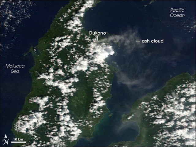 |
Figure 3. Inferred ash plume of Dukono volcano streaming E and then S on 5 December 2006. NASA image created by Jesse Allen, Earth Observatory, using data provided courtesy of the MODIS Rapid Response team. |
As of early 2007, the Darwin Volcanic Ash Advisory Center (VAAC) reported that plumes from Dukono were visible on satellite imagery several times during 2006, and once in January 2007 (see table 3). Satellite images suggested modest successive plumes with ash concentrations varying from diffuse to dense.
Table 3. Summary of plumes reported from Dukono, January 2006-January 2007. Courtesy of the Darwin VAAC.
| Date | Plume top (altitude) | Plume drift direction | Comment |
| 12 Jan 2006 | 3 km | SW | ash |
| 23 Aug 2006 | -- | NNE | diffuse ash |
| 05 Dec 2006 | 3 km | ENE | ash |
| 22 Dec 2006 | -- | SE | diffuse ash |
| 16 Jan 2007 | -- | SSE | diffuse |
Thermal anomalies were detected by MODIS (table 4) on 13 December 2006 and then on four days in February 2007. These were the first anomalies detected by the MODVOLC system since October 2004 (BGVN 31:06).
Table 4. Thermal anomalies at Dukono based on MODIS-MODVOLC retrievals and processing from October 2004 through February 2007. Courtesy of Hawai'i Institute of Geophysics and Planetology Thermal Alerts System.
| Date (UTC) | Time (UTC) | Pixels | Satellite |
| 04 Oct 2004 | 1350 | 2 | Terra |
| 13 Dec 2006 | 1350 | 1 | Terra |
| 13 Feb 2007 | 1405 | 1 | Terra |
| 13 Feb 2007 | 1700 | 1 | Aqua |
| 15 Feb 2007 | 1350 | 1 | Terra |
| 18 Feb 2007 | 1715 | 1 | Aqua |
| 24 Feb 2007 | 1345 | 1 | Terra |
Geological Summary. Reports from this remote volcano in northernmost Halmahera are rare, but Dukono has been one of Indonesia's most active volcanoes. More-or-less continuous explosive eruptions, sometimes accompanied by lava flows, have occurred since 1933. During a major eruption in 1550 CE, a lava flow filled in the strait between Halmahera and the N-flank Gunung Mamuya cone. This complex volcano presents a broad, low profile with multiple summit peaks and overlapping craters. Malupang Wariang, 1 km SW of the summit crater complex, contains a 700 x 570 m crater that has also been active during historical time.
Information Contacts: Center of Volcanology and Geological Hazard Mitigation (CVGHM), Jalan Diponegoro 57, Bandung 40122, Indonesia (URL: http://www.vsi.esdm.go.id/); Darwin Volcanic Ash Advisory Center (VAAC), Bureau of Meteorology, Darwin, Australia (URL: http://www.bom.gov.au/); Hawai'i Institute of Geophysics and Planetology (HIGP) Thermal Alerts System, School of Ocean and Earth Science and Technology (SOEST), Univ. of Hawai'i, 2525 Correa Road, Honolulu, HI 96822, USA (URL: http://modis.higp.hawaii.edu/).