Report on Pagan (United States) — January 2007
Bulletin of the Global Volcanism Network, vol. 32, no. 1 (January 2007)
Managing Editor: Richard Wunderman.
Pagan (United States) December 2006 eruption's long plumes and ashfall
Please cite this report as:
Global Volcanism Program, 2007. Report on Pagan (United States) (Wunderman, R., ed.). Bulletin of the Global Volcanism Network, 32:1. Smithsonian Institution. https://doi.org/10.5479/si.GVP.BGVN200701-284170
Pagan
United States
18.13°N, 145.8°E; summit elev. 570 m
All times are local (unless otherwise noted)
At 1800 on 4 December 2006 scientists from the Hawaiian Volcano Observatory (HVO) and Emergency management Office (EMO) were advised by Pagan residents of ashfall at their camp. They continued to report light ashfall (through an unreported date), with up to a centimeter per day accumulating 3 km SW of the summit and a plume rising about 60 m above the vent. There were no felt earthquakes or noise from the volcano, but occasional sulfur smells wafted through the camp.
Visible satellite imagery interpreted by the Washington VAAC showed a small gas plume, possibly with minor ash, at 0733 on 5 December. Cloud cover made satellite observations difficult, but during 5-6 December plumes could be distinguished extending as far as 185 km W. A Terra MODIS image on 6 December (figure 6) showed the plume near the island to be light brown in color, indicating ash content. A serpentine-shaped plume at 0833 on 7 December extended 140 km WSW from the island. Later that day, at 1300, a faint narrow plume could still be seen to a distance of about 300 km W. The last visible imagery that showed an ash plume was at 1633 on 8 December; the plume was very narrow and at low altitudes.
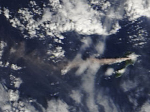 |
Figure 6. Terra MODIS image showing a light brown ash plume blowing W from Pagan, 6 December 2006. Courtesy of NASA Earth Observatory and the MODIS Rapid Response Team at Goddard Space Flight Center. |
Although significant eruptive activity seemed to have ended on 8 December, observations from the International Space Station revealed a plume on 11 January 2007 (figure 7). The very diffuse plume was most likely steam. There were no reports of ash plumes from the island or warnings to aviators based on satellite data after 8 December 2006.
 |
Figure 7. Photograph showing a thin plume extending SW from Pagan on 11 January 2007. [Astronaut photograph ISS014-E-11872 was acquired with a Kodak 760C digital camera using a 180 mm lens.] Courtesy of NASA Earth Observatory, the ISS Crew Earth Observations experiment, and the Image Science & Analysis Laboratory, Johnson Space Center. |
Eruption during 1993-94. The eruption that began around mid-January 1993 (BGVN 18:03) continued through at least 30 April 1994 (figure 8). Fieldwork by USGS and EMO scientists during April and May 1994 was not previously reported in the Bulletin. Trusdell and others (2006) noted that following the eruption in 1981 (SEAN 06:04), "Intermittent light ejection of chiefly phreatic ash continued until 1996, with maximum post-1981 accumulation estimated at as much as 1-2 m on the source cone."
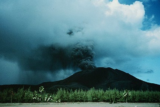 |
Figure 8. Ash plume erupting from Pagan, 30 April 1994. View is to the S. Courtesy of Frank Trusdell, USGS. |
References. Sako, M.K., Trusdell, F.A., Koyanagi, R.Y., Kojima, G., and Moore, R.B., 1995, Volcanic investigations in the Commonwealth of the Northern Mariana islands, April to May 1994: U. S. Geological Survey Open-File Report 94-705, 57 p.
Trusdell, F.A., Moore, R.B., and Sako, M.K., 2006, Preliminary geologic map of Mount Pagan volcano, Pagan Island, Commonwealth of the Northern Mariana Islands: U. S. Geological Survey Open-File Report 2006-1386, 32 p.
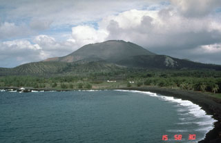
Geological Summary. Pagan Island, the largest and one of the most active of the Mariana Islands volcanoes, consists of two stratovolcanoes connected by a narrow isthmus. Both North and South Pagan stratovolcanoes were constructed within calderas, 7 and 4 km in diameter, respectively. North Pagan at the NE end of the island rises above the flat floor of the northern caldera, which may have formed less than 1,000 years ago. South Pagan is a stratovolcano with an elongated summit containing four distinct craters. Almost all of the recorded eruptions, which date back to the 17th century, have originated from North Pagan. The largest eruption during historical time took place in 1981 and prompted the evacuation of the sparsely populated island.
Information Contacts: Emergency Management Office of the Commonwealth of the Northern Mariana Islands (EMO-CNMI), PO Box 100007, Saipan, MP 96950, USA (URL: http://www.cnmihsem.gov.mp/); U.S. Geological Survey, Hawaiian Volcano Observatory (HVO), PO Box 51, Hawaii National Park, HI 96718, USA (URL: https://volcanoes.usgs.gov/nmi/activity/); NASA Earth Observatory (URL: http://earthobservatory.nasa.gov/).