Report on Heard (Australia) — June 2007
Bulletin of the Global Volcanism Network, vol. 32, no. 6 (June 2007)
Managing Editor: Richard Wunderman.
Heard (Australia) Eruption ends in April; three eruptions of more than 11 months long since 2000
Please cite this report as:
Global Volcanism Program, 2007. Report on Heard (Australia) (Wunderman, R., ed.). Bulletin of the Global Volcanism Network, 32:6. Smithsonian Institution. https://doi.org/10.5479/si.GVP.BGVN200706-234010
Heard
Australia
53.106°S, 73.513°E; summit elev. 2745 m
All times are local (unless otherwise noted)
Based on Hawai'i Institute of Geophysics and Planetology (HIGP) Thermal Alerts System MODVOLC analysis of MODIS (Moderate Resolution Imaging Spectroradiometer) satellite thermal anomaly data, Matt Patrick reported in June 2007 that the eruption at Heard that started about a year ago (BGVN 31:05, 31:11, and 32:03) seemed to have ceased. Due to its isolated location, Heard Island is rarely visited, and satellite imagery provides the only regular information on eruptive activity. There have been three eruptive periods of 11 months or longer during which thermal anomalies were frequent since MODIS data came online in early 2000 up to 21 July 2007 (table 4).
Table 4. Summary of eruptive episodes at Heard based on MODVOLC analyses of MODIS thermal satellite data. Courtesy of Matt Patrick.
| Eruption | First Anomaly | Last Anomaly | Duration | Comments |
| 2000-2001 | 07 Mar 2000 | 02 Feb 2001 | 332 days | 857 days until next eruption. An earlier report (BGVN 28:01) indicated that this eruption began in May 2000, while Patrick's data indicated that MODIS thermal alerts began in March 2000. |
| 2003-2004 | 09 Jun 2003 | 14 Jun 2004 | 371 days | 635 days until next eruption. |
| 2006-2007 | 11 Mar 2006 | 06 Apr 2007 | 391 days | A single anomaly on 11-12 March 2006 was followed by lack on anomalies until 6 May, when they became frequent. (Note: since 6 April 2007, only one, single-pixel anomaly has been measured--24 July 2007. Patrick concluded that the 2006-2007 eruptive phase of nearly daily alerts ended on 6 April 2007.) |
A graph prepared by Patrick and the HIGP Thermal Alert System Team (figure 13) showing radiant heat output and distance of alert pixels from the volcano vent (1 pixel=1 km) also shows the three separate eruptions since 2000. Pixel distances determined from Advanced Spaceborne Thermal Emission and Reflection Radiometer (ASTER) data and the MODVOLC alert show that activity during all three eruptions was centered around the summit crater, with sporadic lava flows during the 2000-2001 and 2006-2007 episodes. Only the 2000-2001 eruption clearly featured long (i.e. several kilometer long) lava flows, as shown by the > 3 km distance in July 2000 (figure 13). Patrick noted that a 2-km-long lava flow seen in Landsat imagery early in the 2000 eruption, on 7 July 2000 (figure 14), was detected by MODVOLC on 10 July 2000. However, since the location of the MODVOLC alerts from that time period were not far from the source vent, the alerts were not effective for showing the length of the lava flow.
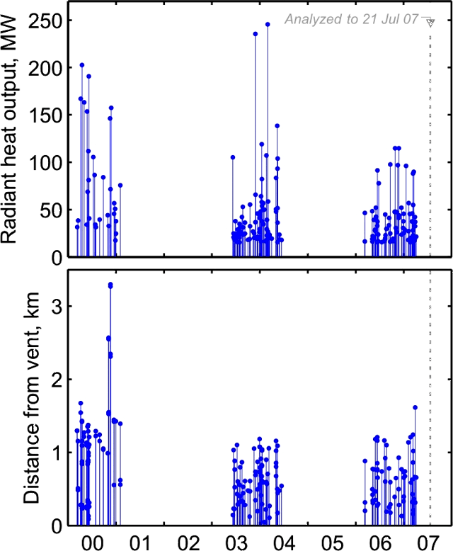 |
Figure 13. MODVOLC data for Heard showing radiant heat output (top) and distance of alert pixels from the vent (bottom), January 2000-21 July 2007. Courtesy of Matt Patrick. |
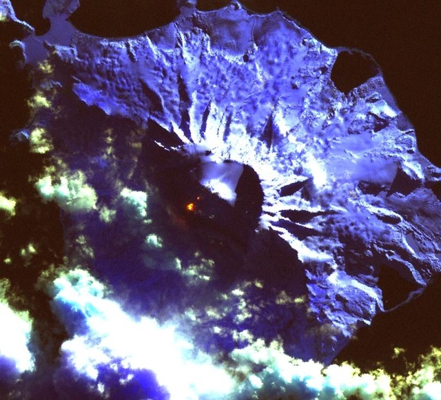 |
Figure 14. Landsat image showing active flow at Heard Island, 7 July 2000. Courtesy of Matt Patrick. |
The 2003-2004 and 2006-2007 activity appeared to be largely limited to the summit crater, as indicated by the small MODVOLC distances (i.e. 1 km or less, with 1 km being the size of the pixels and inherent uncertainty) and ASTER data examined. ASTER data did show a possible 900-m-long flow to the SW of the vent in May 2006 (BGVN 31:05 and 31:11) and a clear 700-m-long flow of lava extending NE of the summit crater in December 2006, indicating that small effusive events have occurred in addition to central vent activity in the 2006-2007 phase. Patrick has not observed to this time any obvious ash plumes in the ASTER images, but all of the images examined appeared to be partly cloudy.
Patrick noted that it is difficult to determine exactly how often thermal anomalies for Heard Island may be completely obscured by clouds. The benefit of MODIS is the 1-2 observations per day, so that if activity is indeed present, it should not elude detection for very long. In the MODVOLC plot (figure 13), there were fairly regular alerts over the course of a year or so at a time, during which there must have been some cloud cover.
Geological Summary. Heard Island on the Kerguelen Plateau in the southern Indian Ocean consists primarily of the emergent portion of two volcanic structures. The large glacier-covered composite basaltic-to-trachytic cone of Big Ben comprises most of the island, and the smaller Mt. Dixon lies at the NW tip of the island across a narrow isthmus. Little is known about the structure of Big Ben because of its extensive ice cover. The active Mawson Peak forms the island's high point and lies within a 5-6 km wide caldera breached to the SW side of Big Ben. Small satellitic scoria cones are mostly located on the northern coast. Several subglacial eruptions have been reported at this isolated volcano, but observations are infrequent and additional activity may have occurred.
Information Contacts: Matt Patrick, Dept. of Geological and Mining Engineering and Sciences, Michigan Technological University, 1400 Townsend Drive, Houghton, MI 49931, USA; Hawai'i Institute of Geophysics and Planetology (HIGP) Thermal Alerts System, School of Ocean and Earth Science and Technology (SOEST), Univ. of Hawai'i, 2525 Correa Road, Honolulu, HI 96822, USA (URL: http://modis.higp.hawaii.edu/); NASA Earth Observatory (URL: http://earthobservatory.nasa.gov/NaturalHazards/).