Report on Kilauea (United States) — June 2007

Bulletin of the Global Volcanism Network, vol. 32, no. 6 (June 2007)
Managing Editor: Richard Wunderman.
Kilauea (United States) April to June 2007 activity; rift zone earthquakes and extension
Please cite this report as:
Global Volcanism Program, 2007. Report on Kilauea (United States) (Wunderman, R., ed.). Bulletin of the Global Volcanism Network, 32:6. Smithsonian Institution. https://doi.org/10.5479/si.GVP.BGVN200706-332010
Kilauea
United States
19.421°N, 155.287°W; summit elev. 1222 m
All times are local (unless otherwise noted)
According to the Hawaiian Volcano Observatory (HVO) of the U.S. Geological Survey (USGS), Kīlauea's eruption that began in 1983 had by January 2007 emitted 3.1 km3 of lava, covering 117 km2 of land surface, and adding 201 hectares (201 x 104 m2) to Kīlauea's southern shore. HVO has divided the multi-decade eruptive interval into a series of episodes, and on 19 June 2007 they announced the start of episode 56. This background section provides context on the later report consisting of subsections discussing 1 April-19 June 2007 (episode 55) activity and some large earthquakes during 2006 and 2007.
Figure 185 provides an overview of the E and SW rift zones. The lower diagram shows relationships between major features on the surface and those inferred at depth. The ongoing eruption has often emitted lavas from it's upslope vent, Pu`u `O`o, leaving an upper flow-field laden with a complex series of lava flows, lava tubes, and related features.
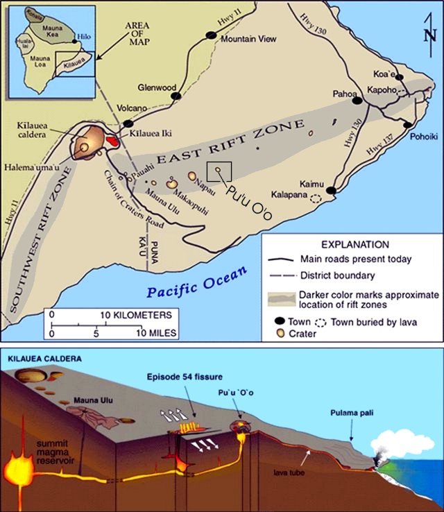 |
Figure 185. Plan-view and cross-sectional diagrams illustrating the island of Hawaii (the largest and southernmost in the Hawaiian chain) showing selected volcanological features. The inset shows the five volcanoes that comprise the island (old to young): Kohala, Hualalai, Mauna Kea, Mauna Loa, and Kīlauea. Kīlauea is cut by the SW and E rift zones, and the summit caldera lies near their intersection. From the summit caldera the E rift zone extends 55 km to the eastern tip of the island. Along that path lies a string of craters, including Mauna Ulu and Pu`u `O`o. The cross-section displays a simplified model of Kīlauea's inferred internal structure. Note the location of vents, at Pu`u `O`o and elsewhere along a fissure, along the E rift zone. The diagram also shows a lava tube running from Pu`u `O`o to the sea. Courtesy of HVO-USGS. |
Figure 186 consists of a map of the Pu`u `O`o region of Kīlauea and the names applied to many of the features there as of June 2006. For comparison, maps current through parts of 2004 appeared previously (BGVN 29:02 and 29:09). A newer map created during late 2006 extends coverage slightly farther to the S (figure 187). The Campout flow discharged from the Prince Kuhio Kalaniana`ole (PKK) lava tube at a spot ~ 1 km S of Pu`u `O`o.
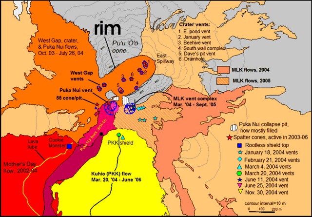 |
Figure 186. Map of Kīlauea's upper SE flank made in June 2006. The map shows the Pu`u `O`o cone and crater ("rim" points to the crater's NW rim), along with nearby vents, lava flows, and numerous other features. Approximate area is outlined in figure 185. Features active in 2005-06 included the numbered vents in the crater, the MLK vent complex and associated lava flows, and the Puka Nui vent. The upper PKK (Kuhio) lava flow, with an associated tube (solid line) feeds lava flows that reach the ocean. Courtesy of USGS-HVO. |
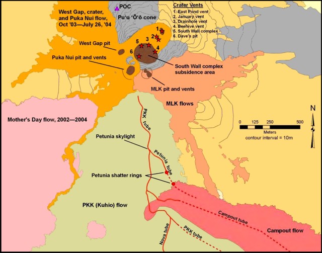 |
Figure 187. Map of Kīlauea showing events at Pu`u `O`O and vicinity through December 2006. The map shows the upper flow field, including the location of crater and flank vents, collapse and subsidence areas, lava tubes and new shatter rings, and the upper Campout flow. Courtesy of HVO (HVO, 2006). |
The Campout flow emerged during May 2006. It advanced over the surface and ultimately reached the ocean (figure 188). The Campout flow later evolved a lava tube system that extended 8-10 km S, bringing lava to an ocean entry at E Ka`ili`ili. A third entry, fed by an offshoot of the Campout flow, became active on 26 December 2006. The PKK lavas met the sea at E Lae`apuki.
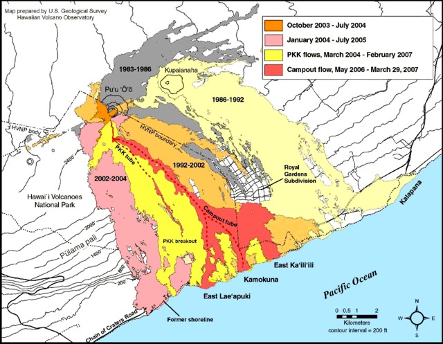 |
Figure 188. Map of Kīlauea's eruption site showing the location of lava flows, tubes, and ocean entries active during January-March 2007. Courtesy of HVO-USGS. |
Activity during 1 April-19 June 2007. Our previous report noted lava flows reaching the ocean between December 2006 and March 2007 (BGVN 32:05). Earthquake swarms that began in mid-May along the upper rift are discussed in a separate subsection below.
During 1 April to 19 June 2007, several key pathways remained active down Kīlauea's flanks (figures 187 and 188). First, lava emerged from the PKK tube at the top of Pulama pali and then continued as surface flows down the pali. The Campout lava tube continued to provide lava to the coast at the Kamokuna ocean entry. The Campout lava tube also fed an eastward branch that emerged at the low-elevation end of the Royal Gardens, a long-abandoned housing subdivision (figure 188) where lava ignited fires on 11 April. The Campout lava tube also fed a westward branch to the coastal plain inland of the E Lae`apuki sea cliff, although the ocean entry was not visible. During the reporting interval, Kamokuna was the only consistently active ocean entry point.
During 4-24 April, incandescence was intermittently visible from several breakouts on the Pulama pali and from several vents in Pu'u 'O'o's crater. On 11 April, lava from the E arm of the Campout flow ignited fires at the base of the long-abandoned housing sub-division called Royal Gardens.
Throughout May, lava from Kīlauea continued to flow SE across a lava delta into the ocean at the Kamokuna entry. Incandescence was visible from several vents in the Pu'u 'O'o crater and from breakouts on, above, and at the base of the Pulama pali fault scarp. During 3-4 May, the Campout flow sent large channelized a'a' flows descending down the pali. On 4 May, a sheet flow ponded lava at the base of the Royal Gardens.
On 8 May, HVO scientists reported that for the past several months, Kīlauea caldera widened at a rate of 1.5 cm/month. Multiple updates around this time noted that Pu'u 'O'o crater was slowly collapsing. This was indicated by both new cracks on the S flank and subsidence of the N flank at a rate of 1 cm/month.
On 10 May, ~ 6.5 hectares of the E Lae`apuki bench collapsed, starting from the E-side and moving progressively westward. Observers saw the collapse during the time interval 1625-1900. The event generated the strongest seismic signals during 1711-1855. Each section of collapse generated steam-plume emissions occasionally blackened by rock fragments. The plumes resulted from the explosive interaction between seawater and incandescent rock exposed immediately after each section collapsed. On 11 May, HVO scientists surveyed the collapse and mapped cracks inland of the sea cliff. They found recently fallen fragments covering 1.2 hectares.
On 16 May, lava from the E-arm of the Campout flow advanced along the coastal plain from the base of the Royal Gardens to reach the ocean at Poupou, a spot ~ 1.6 km E of the Kamokuna entry. On 18 May, HVO field crews reported a delta there reaching 20 m wide. At Poupou, during 23 May-19 June, lava continued to flow SE across this growing lava delta into the ocean. By 24 May, lava had ceased entering the ocean at Kamokuna.
On 18 May, a large lava flow broke out of the PKK lava tube at the site of an old skylight named Petunia. The skylight connected to the PKK lava tube ~ 400 m SE from the tube's head. The Petunia skylight (figure 187) is located in the midst of the upper PKK flows. Color photos of the lava venting on 18 May (figure 189) indicate that the new lava flows have large tongues with prominent zones of incandescence.
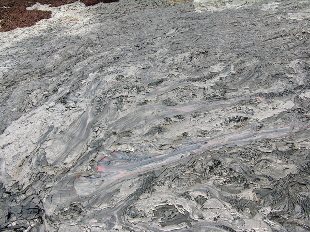 |
Figure 189. An oblique aerial photo showing a new vent in Kīlauea's upper flow field, 18 May 2007. On this date the former Petunia skylight served as the vent for a fairly large lava flow. The point of emission is at the lower left, with lava flowing towards the right (moving S or SE). The new lavas extruded amid the much broader PKK (Kuhio) flow. Courtesy of HVO. |
The 18 May HVO update noted that on the coastal plain, 1-2 km2 of hot, inflating flows were oozing between Royal Gardens subdivision and the Poupou entry. The advance toward the coast had become three-pronged, two on either edge of the now inactive Ka`ili`ili branch of the Campout flow and one farther E. The middle prong fed the growing Poupou entry. The western prong, advancing along the the western edge of the same branch, is still more than 800 m from the ocean. A narrow eastern prong advanced along the far eastern boundary of the National Park, and still remained ~ 500 m from the ocean. This pattern of behavior continued through the rest of May.
The 2 June HVO report stated that the PKK lava tube, still the primary tube from Pu`u `O`o, fed the Campout and the Petunia lava tubes. The Petunia flow had advanced ~ 2 km but was not yet visible below the pali. The Kamokuna and E Lae`apuki ocean entries were not active.
During the week 6-12 June 2007, aerial and satellite observations confirmed that the Petunia flow remained active but was still about the same length. Surface flows were also documented inland of the Poupou entry on the E side of the flow field. On 14 June, the Petunia flow went over the top of the Pulama pali. On 16 June, the front of the Petunia flow advanced down the Pulama pali and was ~ 90-180 m wide.
An E rift intrusion was inferred from increased activity at Kīlauea's summit on 17 June. By the morning of 19 June, a small pad of lava was erupted on the NE flank of Kane Nui o Hamo shield. When crews conducted ground-based mapping of the new lava flow about a week later, HVO reported that the eruption occurred from two places along the fissure, separated by ~ 40 m.
Kiholo Bay earthquake, October 2006. On 15 October 2006 an Mw 6.7 earthquake struck off the NNW shore of the island of Hawaii (~ 11 km NNW of the town of Kalaoa). The focal depth was 29 km. Seven minutes later an Mw 6.0 event followed, part of over 50 aftershocks that occurred.
The intensity was strongest slightly NE of the bay, where it yielded a maximum Modified Mercali value of VII-VIII (very strong to severe). It was felt throughout the region; on Maui some areas may have reached intensity VI. Earthquakes of this type are generally inferred to result from bending stresses within the Pacific plate caused by the weight of overlying islands.
Twelve instruments on Hawaii recorded the shaking. Despite its moderate depth, the earthquake generated high accelerations to the epicenter's NE. An instrument at the Waimea fire station measured large peak ground accelerations nearly equivalent to gravity in both the vertical (0.88g) and horizontal (1.05g) components. These peak values, which indicate the high-frequency content of the ground motion, primarily affected acceleration-sensitive bodies, such as liquid in containers and nonstructural elements. The ground motions at longer periods (eg., over 1 second), however, were sufficiently small to avert full-scale building destruction. There were no reported deaths.
The earthquake triggered numerous landslides, closed roads, and damaged at least 1,173 buildings. Power outages occurred throughout the Hawaiian Islands. The damage estimates in a later report were high, over 100 million dollars, roughly twenty-fold larger than others in area, although several had larger magnitudes and intensities.
2007 earthquake swarm on the rift zone. A swarm of moderate magnitude earthquakes took place along Kīlauea's rift zone beginning 12 May 2007. Since 1998, a few earthquakes with magnitudes greater than 4.0 have occurred at shallow depths beneath the upper E rift zone.
For example, HVO recorded an M 4.7 earthquake at 0913 on 24 May, located beneath the upper E rift zone, near Kīlauea's summit at Puhimau crater (at the upper end of Chain of Craters road, figure 185) at a depth of 2 km. On 24 May an M 4.1 aftershock occurred 20 minutes after the main shock, located 1.5 km farther down-rift, beneath Koko`olau crater. An M 3.9 aftershock occurred at 1051 and was located 4 km farther down-rift than the M 4.7 at a depth of 1 km. An M 3.9 aftershock occurred at 1051 and was located another 2.5 km down-rift at a depth of 1 km.
On 17 June, a swarm of earthquakes and rapid deflation began at 0215 in the upper E rift zone. The earthquakes were centered ~ 1 km SW of Mauna Ulu and about 1.5-3 km deep. About 70 earthquakes were recorded in the first 2 hours; at least 10 of those earthquakes were M 3 or greater. National Park Service crews evacuated visitors and closed the Chain of Craters road and the Crater Rim Drive between Jaggar museum and the Thurston lava tube parking lot. Fresh cracks ~ 2 cm wide opened in the Chain of Craters road near the Mauna Ulu turnoff. GPS receivers in the area of most intense seismic activity near Makaopuhi crater documented ~ 10 cm of widening across the rift zone,. HVO observers noted rockfalls from the S wall of Pu`u `O`o cone and collapse of the crater floor around the vents.
Although these were clearly smaller and less damaging than the Kiholo bay earthquake, they occurred along the active vent and fissure system. Substantial earthquakes in this important region continued through at least mid-August (including an M 5.4 earthquake on 13 August).
References. Hawaiian Volcano Observatory, 2006, Quarterly Report of the USGS Hawaiian Volcano Observatory (HVO), October-December 2006.
Hawaiian Volcano Observatory, 2007, Quarterly Report of the USGS Hawaiian Volcano Observatory (HVO), January-March 2007.
Klein, F.W., Frankel, A.D., Mueller, C.S., Wesson, R.L., and Okubo, P.G., 2001, Seismic hazard in Hawaii: high rate of large earthquakes and probabilistic ground motion maps: Bulletin of the Seismological Society of America, v. 91, p. 479-498.
Robertson, I.N., Nicholson, P.G., and Brandes, H.G., 2006, Reconnaissance Following the October 15th, 2006 Earthquakes on the Island of Hawai'i: University of Hawaii, Department of Civil and Environmental Engineering Research Report, UHM/CEE/06-07 (URL: http://www.cee.hawaii.edu/).
U.S. Geological Survey Community Internet Intensity Map, 2006 (http://pasadena.wr.usgs.gov/shake/STORE/Xtwbh_06/ciim_display.html).
U.S. Geological Survey ShakeMaps, 2006, (URL: http://earthquake.usgs.gov/eqcenter/shakemap/global/shake/twbh_06/).
Geological Summary. Kilauea overlaps the E flank of the massive Mauna Loa shield volcano in the island of Hawaii. Eruptions are prominent in Polynesian legends; written documentation since 1820 records frequent summit and flank lava flow eruptions interspersed with periods of long-term lava lake activity at Halemaumau crater in the summit caldera until 1924. The 3 x 5 km caldera was formed in several stages about 1,500 years ago and during the 18th century; eruptions have also originated from the lengthy East and Southwest rift zones, which extend to the ocean in both directions. About 90% of the surface of the basaltic shield volcano is formed of lava flows less than about 1,100 years old; 70% of the surface is younger than 600 years. The long-term eruption from the East rift zone between 1983 and 2018 produced lava flows covering more than 100 km2, destroyed hundreds of houses, and added new coastline.
Information Contacts: Hawaiian Volcano Observatory (HVO), U.S. Geological Survey, PO Box 51, Hawai'i National Park, HI 96718, USA (URL: https://volcanoes.usgs.gov/observatories/hvo/); Associated Press.