Report on Krakatau (Indonesia) — September 2007

Bulletin of the Global Volcanism Network, vol. 32, no. 9 (September 2007)
Managing Editor: Richard Wunderman.
Krakatau (Indonesia) Minor eruptions beginning October 2007; seismic data for 2005-2007
Please cite this report as:
Global Volcanism Program, 2007. Report on Krakatau (Indonesia) (Wunderman, R., ed.). Bulletin of the Global Volcanism Network, 32:9. Smithsonian Institution. https://doi.org/10.5479/si.GVP.BGVN200709-262000
Krakatau
Indonesia
6.1009°S, 105.4233°E; summit elev. 285 m
All times are local (unless otherwise noted)
Eruptive activity in recent years was low at Krakatau. The Indonesian volcanological monitoring agency, now called the Center of Volcanology and Geological Hazard Mitigation (CVGHM), did not report any eruptive activity between June 2005 and September 2007. Seismic data collected during this period (figures 15 and 17), although intermittent and variable, suggests mainly low-level activity (discussed in more detail below).
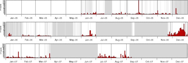 |
Figure 15. Volcano-tectonic earthquakes recorded at Anak Krakatau, June 2005-early September 2007. Grayed-out areas represent periods when seismic data were not available. Courtesy of CVGHM. |
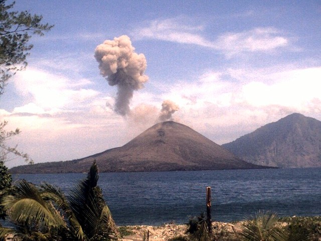 |
Figure 16. Photograph of an ash plume from Anak Krakatau, 1 November 2007. View is to the SE from a monitoring station on Sertung island. Rakata island is in the background. Courtesy of CVGHM. |
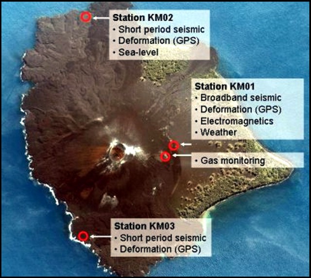 |
Figure 17. Satellite image of Anak Krakatau showing part of the monitoring network. Stations KM01, KM02, and KM03 are equipped with seismometers (broad-band at KM01) and GPS systems for deformation monitoring. A weather station is installed at KM01, a sea-level sensor at KM02. An electro-magnetic station (KM05) is located near station KM01. Gases are monitored at a nearby fumarole. Courtesy of CVGHM. |
Starting on 23 October 2007 reports noted multiple gray plumes from eruptions lasting 3-6 minutes; these vented from a crater near the summit of Anak Krakatau (figure 16). The eruptions and associated increased seismicity during 23-26 October 2007 prompted CVGHM to raise the Alert Level to 3. Poor weather conditions allowed only intermittent observations, but plumes rose to an altitude of ~ 1 km during 23-26 and 30 October. Similar eruptions were continuing in early November (figure 16).
Activity during April 2005-September 2007. On 13 April 2005 increased seismicity prompted authorities to raise the Alert Level to 2 (on a scale of 1-4). Seismic activity decreased over the next four days to a normal level. Visitors were banned from the summit and crater of Anak Krakatau due to toxic gas emission. Another increase in seismic activity was reported around 16 May. Elevated seismicity was also recorded on 24 September 2005, 8 December 2005, and 18-19 June 2006 (figure 15).On figure 15, a conspicuous, longer period of high seismicity occurred during most of December 2006, when tremor and low-frequency events also increased. That peak on figure 15 ended prior to the end of the month. No eruptions were noted in available reports by CVGHM for these episodes of elevated seismicity in 2005 or 2006. For the intervals where data were available during the first eight months of 2007, seismicity was generally moderate to low.
Monitoring. The monitoring system (KRAKMON) consists of a number of geophysical, gas-geochemical, and environmental measuring sites on the Krakatau island complex. All data are acquired continuously and are transmitted to the Pasauran Observatory (western Java) via digital radio telemetry. In Pasauran, the data are collected and transmitted to a server in Jakarta. From there, the data were accessible through internet (http://krakmon.vsi.esdm.go.id/). Three stations are located on Anak Krakatau (figure 17). A fourth station on Sertung island consists of a short-period seismometer and a digital camera with a view of Anak Krakatau.
Geological Summary. The renowned Krakatau (frequently mis-named as Krakatoa) volcano lies in the Sunda Strait between Java and Sumatra. Collapse of an older edifice, perhaps in 416 or 535 CE, formed a 7-km-wide caldera. Remnants of that volcano are preserved in Verlaten and Lang Islands; subsequently the Rakata, Danan, and Perbuwatan cones were formed, coalescing to create the pre-1883 Krakatau Island. Caldera collapse during the catastrophic 1883 eruption destroyed Danan and Perbuwatan, and left only a remnant of Rakata. This eruption caused more than 36,000 fatalities, most as a result of tsunamis that swept the adjacent coastlines of Sumatra and Java. Pyroclastic surges traveled 40 km across the Sunda Strait and reached the Sumatra coast. After a quiescence of less than a half century, the post-collapse cone of Anak Krakatau (Child of Krakatau) was constructed within the 1883 caldera at a point between the former Danan and Perbuwatan cones. Anak Krakatau has been the site of frequent eruptions since 1927.
Information Contacts: Center of Volcanology and Geological Hazard Mitigation (CVGHM), Saut Simatupang, 57, Bandung 40122, Indonesia (URL: http://vsi.esdm.go.id/).