Report on Suwanosejima (Japan) — November 2007
Bulletin of the Global Volcanism Network, vol. 32, no. 11 (November 2007)
Managing Editor: Richard Wunderman.
Suwanosejima (Japan) Eruptions of July 2005-December 2007 send plumes to varying heights
Please cite this report as:
Global Volcanism Program, 2007. Report on Suwanosejima (Japan) (Wunderman, R., ed.). Bulletin of the Global Volcanism Network, 32:11. Smithsonian Institution. https://doi.org/10.5479/si.GVP.BGVN200711-282030
Suwanosejima
Japan
29.638°N, 129.714°E; summit elev. 796 m
All times are local (unless otherwise noted)
Suwanose-jima, in the East China sea, is one of Japan's most active volcanoes. Our last report on Suwanose-jima (BGVN 30:07) tabulated the seismicity and the numerous ash plumes seen between April 2004 and July 2005. The current report continues the tabulation from August 2005 to December 2007 (table 4).
Table 4. Summary of activity reported at Suwanose-jima from August 2005 to December 2007, based on information from the Tokyo VAAC. "--" indicates that data were not reported.
| Date | Activity | Plume Altitude (km) | Drift Direction |
| 11 Aug-12 Aug 2005 | Small eruptions | ~ 3.4 | -- |
| 22 Sep 2005 | Plume | ~ 1.8 | W |
| 07 Oct-09 Oct 2005 | Eruptions | max. 1.8 | SW, E, SE |
| 01 Jan 2006 | Explosions | -- | -- |
| 10 Jan 2006 | Explosions | ~ 1.8 | E |
| 24 Jan 2006 | Plume | 1.5 | E |
| 28 Jan 2006 | Plume | max. 1.8 | W |
| 29 Jan 2006 | Explosion | -- | -- |
| 31 Jan 2006 | Plume | 1.5 | W |
| 01 Feb 2006 | Explosions | -- | -- |
| 06 Feb-07 Feb 2006 | Explosions | 1.2 | NW |
| 08 Feb-10 Feb 2006 | Plumes | max. 1.5 | E and SE |
| 15 Feb-18 Feb 2006 | Plumes | max. 1.5 | E and S |
| 22 Feb-24 Feb 2006 | Eruptions | max. ~ 3 | S, E, NE |
| 02 Mar-08 Mar 2006 | Explosions | max. ~ 1.8 | E, SE, S, NW |
| 16 Apr 2006 | Ash plume | ~ 1.5 | -- |
| 07 Jun 2006 | Ash plume | 2.4 | -- |
| 30 Jun 2006 | Plume | 1.2 | NE |
| 16 Jul 2006 | Ash plume | 1.8 | N |
| 26 Jul-30 Jul 2006 | Explosions | max. ~ 1.8 | N, straight up |
| 11 Aug-14 Aug 2006 | Explosions | max. ~ 1.8 | N and W |
| 26 Aug 2006 | Plumes | 1.8 | Straight up |
| 28 Aug 2006 | Plumes | 1.5 | E |
| 19 Sep 2006 | Ash plumes | 3.4 | E |
| 20 Sep 2006 | Ash and steam | 2.1 | N |
| 06 Oct 2006 | Explosion | -- | -- |
| 14, 16-17 Oct 2006 | Ash plumes | 3 | -- |
| 18 Oct 2006 | Explosion | -- | -- |
| 27 Oct-28 Oct 2006 | Ash plumes | 1.8 | E |
| 04 Nov-06 Nov 2006 | Plumes | 1.2 | E and SW |
| 09 Nov 2006 | Plume | 1.5 | W |
| 17 Nov 2006 | Plume | 2.1 | Straight up |
| 19 Dec 2006 | Eruption | -- | -- |
| 09 Jan 2007 | Plume | -- | -- |
| 28 Jan 2007 | Plume | -- | -- |
| 05 Feb-07 Feb 2007 | Plume | -- | -- |
| 19 Feb-20 Feb 2007 | Plumes | -- | -- |
| 02 Mar 2007 | Plume | 1.2 | W |
| 17 Mar 2007 | Explosion | -- | -- |
| 30 Mar 2007 | Explosion | -- | -- |
| 02 Apr 2007 | Explosion | -- | -- |
| 08 May 2007 | Explosions | -- | -- |
| 26 Jul 2007 | Ash plume | 1.5 | SW |
| 17 Sep 2007 | Explosions | -- | -- |
| 16 Oct 2007 | Plume | 1.5 | E |
| 22 Oct 2007 | Plume | 1.5 | W |
| 26 Oct-28 Oct 2007 | Plumes | 1.5 | E and W |
| 29 Nov-02 Dec 2007 | Plumes | 1.2-1.8 | E |
| 10 Dec 2007 | Plumes | 1.5-1.8 | W |
| 14 Dec-17 Dec 2007 | Plumes | 1.5-1.8 | E |
During the reporting interval, the Tokyo Volcanic Ash Advisory Center reported small explosions or eruptions, usually accompanied by ash plumes, every month during this period, except for November and December 2005, May 2006, and June 2007. Ash was seldom identified on satellite imagery. On 20 September 2006, the Moderate Resolution Imaging Spectroradiometer (MODIS) on NASA's Terra satellite detected ash-and-steam emissions (figure 11).
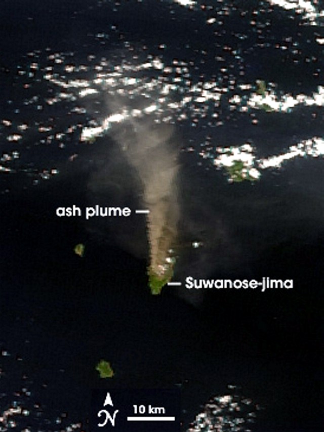 |
Figure 11. Ash plume blowing N from Suwanose-jima on 20 September 2006, seen in a MODIS image. In color images the plume's hue clearly distinguishes it from the banks of transversely oriented white weather clouds. NASA image created by Jesse Allen, Earth Observatory, using data provided courtesy of the MODIS Rapid Response team. |
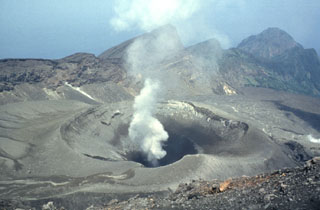
Geological Summary. The 8-km-long island of Suwanosejima in the northern Ryukyu Islands consists of an andesitic stratovolcano with two active summit craters. The summit is truncated by a large breached crater extending to the sea on the E flank that was formed by edifice collapse. One of Japan's most frequently active volcanoes, it was in a state of intermittent Strombolian activity from Otake, the NE summit crater, between 1949 and 1996, after which periods of inactivity lengthened. The largest recorded eruption took place in 1813-14, when thick scoria deposits covered residential areas, and the SW crater produced two lava flows that reached the western coast. At the end of the eruption the summit of Otake collapsed, forming a large debris avalanche and creating an open collapse scarp extending to the eastern coast. The island remained uninhabited for about 70 years after the 1813-1814 eruption. Lava flows reached the eastern coast of the island in 1884. Only about 50 people live on the island.
Information Contacts: Tokyo Volcanic Ash Advisory Center (Tokyo VAAC), Japan Meteorological Agency (JMA), 1-3-4 Ote-machi, Chiyoda-ku, Tokyo 100, Japan (URL: https://ds.data.jma.go.jp/svd/vaac/data/); NASA Moderate Resolution Imaging Spectroradiometer (MODIS) program (URL: http://modis.gsfc.nasa.gov/).