Report on Galeras (Colombia) — March 2008

Bulletin of the Global Volcanism Network, vol. 33, no. 3 (March 2008)
Managing Editor: Richard Wunderman.
Galeras (Colombia) Eruption of January 2008
Please cite this report as:
Global Volcanism Program, 2008. Report on Galeras (Colombia) (Wunderman, R., ed.). Bulletin of the Global Volcanism Network, 33:3. Smithsonian Institution. https://doi.org/10.5479/si.GVP.BGVN200803-351080
Galeras
Colombia
1.22°N, 77.37°W; summit elev. 4276 m
All times are local (unless otherwise noted)
As reported in (BGVN 31:07) Galeras displayed dome growth and elevated seismicity from November 2005 through mid-August 2006; ~ 10,000 residents evacuated but the crisis later abated. The key source of this report was the Instituto Colombiano de Geologia y Mineria (INGEOMINAS). This report follows the August 2006 events and covers the period through April 2008.
In September 2006, INGEOMINAS recorded continuing low-level minor earthquakes, M 1.4, corresponding to the movement of fluids at depths between 4 and 8 km and low SO2 fluxes. A fly-over observed gas and steam emissions from the periphery of the active cone with diminished intensity through early November.
Beginning in late November and continuing through December 2006, an increase in the level of the volcanic activity occurred indicating the movement of solid material at focal depths to 9.6 km and at intensities to M 2.1. INGEOMINAS raised the Alert Level from 3 to 2 elevating the hazard status to "likely eruption in days or weeks" on 22 November 2006. The scale extends from 4 (lowest) to 1 ( highest hazard). The change was based on the increase in activity, behavior resembling characteristics that preceded earlier eruptions, i.e., increased earthquake activity associated with rock fractures within 2 km of the surface and weak gas emissions caused by the apparent capping of the lava dome.
On 2 March 2007, a tectonic earthquake was recorded ~ 2 km NNW of Galeras at M 3.5 and focal depth of 8.2 km. On 15 March, observations made with the support of the Colombian Air Force (FACE), showed continuing low rates of gas discharge continuing from secondary craters and fumaroles mainly located in the periphery of the main crater. On 20 March, because of decreased seismicity, low gas emissions, and no indication of changes below the surface of the dome, the Alert Level shifted towards less severe, from 2 to 3 (to "changes in the behavior of volcanic activity have been noted").
On 19 and 21 May 2007, two earthquakes registered, M 3.0 and M 2.1 respectively. These earthquakes were located SW of Galeras and felt by residents. The inclinometer to the SW of the active crater continued showing deformation indicating deeper volcanic activity.
Little volcanic activity occurred through September 2007. From October 2007 through January 2008, INGEOMINAS and the Washington Volcanic Ash Advisory Center reported an increase in gas-and steam plumes emitted from Galeras (table 8). During an overflight on 27 November, thermal images recorded by INGEOMINAS indicated an increase in temperatures at the point sources of emissions. The Alert Level remained at 3. Occasional gas and steam eruptions continued through January 2008.
Table 8. Summary of activity reported at Galeras from October 2007 through January 2008. Based on information from INGEOMINAS and the Washington Volcanic Ash Advisory Center.
| Date | Event | Maximum plume (km) | Plume direction |
| 04 Oct-05 Oct 2007 | Steam, ash | 5.8-6.3 | N, NW |
| 29 Oct-04 Nov 2007 | Steam, ash | 5.7 | -- |
| 05 Nov-11 Nov 2007 | Ash | 4.5-7.2 | NW, W |
| 13 Nov 2007 | Steam | 5.5 | S |
| 21-23 Nov 2007 | Steam and gas | 5.3 | -- |
| 27 Nov 2007 | Steam, gas, ash | 4.4 | NW |
| 03 Dec 2007 | Steam, gas, ash | 5.3 | NW |
| 31 Dec 2007 | Gas and ash | 4.9 | NW |
| 12 Jan 2008 | Steam, gas, ash | 6.3 | -- |
On 11 January 2008, INGEOMINAS noted variations in seismicity associated with greater volumes of gas discharge. On 16-17 January, 5 tremors were recorded near the active cone. Early on 17 January, INGEOMINAS noted the similarity of these events to those preceding the eruptions of 1992, 1993, and 2004-2006.
Later, on the 17th, an explosive eruption was registered by the seismic network and prompted INGEOMINAS to raise the Alert Level from 3 ("changes in the behavior of volcanic activity have been noted") to 1 ("imminent eruption or in course"). The Washington VAAC reported that an ash plume rose to an altitude of 11 km and drifted W. According to a news article, small settlements to the N were ordered to evacuate; about 100 people moved to shelters.
About 2 km away from the main crater, military personnel saw blocks 1.5 m in diameter on a highway. Several impact craters of 17 January were spotted; the largest, ~ 15 m across and ~ 5 m deep (figure 111).
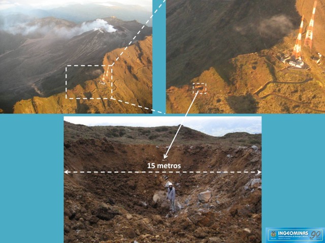 |
Figure 111. A composite of several photos showing a large impact crater formed by the Galeras eruption of 17 January 2008. The impact site was 1.5 km S of the main crater. Courtesy of INGEOMINAS. |
On 19 January 2008, INGEOMINAS lowered the Alert Level to 2 ("likely eruption in days of weeks") because seismic events decreased in occurrence and energy and on 21 January, INGEOMINAS further lowered the Alert Level to 3 and reported that the initial ash plume from the eruption drifted SW, then W. Through February and into March seismic activity remained low. However, in mid-March, a a cluster of earthquakes (several events in a relatively short time interval), associated mainly with movement of magmatic fluids to the interior of the volcanic system were recorded. Volcanic gas and steam columns were routinely observed between 200 and 450 m from the top of Galeras, with variable directions of dispersion depending on the wind direction. Seismicity decreased in early April and SO2 emissions remained low.
Geological Summary. Galeras, a stratovolcano with a large breached caldera located immediately west of the city of Pasto, is one of Colombia's most frequently active volcanoes. The dominantly andesitic complex has been active for more than 1 million years, and two major caldera collapse eruptions took place during the late Pleistocene. Long-term extensive hydrothermal alteration has contributed to large-scale edifice collapse on at least three occasions, producing debris avalanches that swept to the west and left a large open caldera inside which the modern cone has been constructed. Major explosive eruptions since the mid-Holocene have produced widespread tephra deposits and pyroclastic flows that swept all but the southern flanks. A central cone slightly lower than the caldera rim has been the site of numerous small-to-moderate eruptions since the time of the Spanish conquistadors.
Information Contacts: Diego Gomez Martinez, Observatorio Vulcanológico y Sismológico de Pasto (OVSP), INGEOMINAS, Carrera 31, 1807 Parque Infantil, PO Box 1795, Pasto, Colombia (URL: https://www2.sgc.gov.co/volcanes/index.html; Washington Volcanic Ash Advisory Center (VAAC), Satellite Analysis Branch (SAB), NOAA/NESDIS E/SP23, NOAA Science Center Room 401, 5200 Auth Road, Camp Springs, MD 20746, USA (URL: http://www.ospo.noaa.gov/Products/atmosphere/vaac/); Associated Press (URL: http://www.ap.org/).