Report on Rinjani (Indonesia) — June 2009
Bulletin of the Global Volcanism Network, vol. 34, no. 6 (June 2009)
Managing Editor: Richard Wunderman.
Rinjani (Indonesia) Mid-2009 eruptions send lava flows to the caldera lake
Please cite this report as:
Global Volcanism Program, 2009. Report on Rinjani (Indonesia) (Wunderman, R., ed.). Bulletin of the Global Volcanism Network, 34:6. Smithsonian Institution. https://doi.org/10.5479/si.GVP.BGVN200906-264030
Rinjani
Indonesia
8.42°S, 116.47°E; summit elev. 3726 m
All times are local (unless otherwise noted)
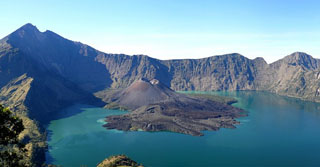
Eruptions at Rinjani (figures 8 and 9) between October 2004 and January 2005 (BGVN 30:02) was the first activity noted since September 1995. On 29 April 2009, the Center of Volcanology and Geological Hazard Mitigation (CVGHM) again detected an increase in earthquakes and tremor, with eruptions from Barujari's cone beginning 2 May 2009 and continuing through 21 June 2009.
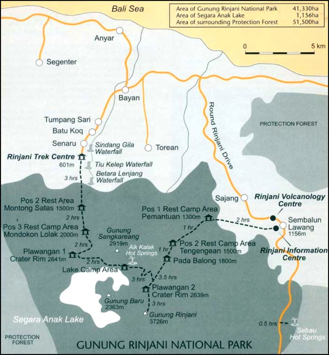 |
Figure 8. Map of Rinjani National Park's campsites and relative elevations. Courtesy of Rinjani Trek Centre (RTC). |
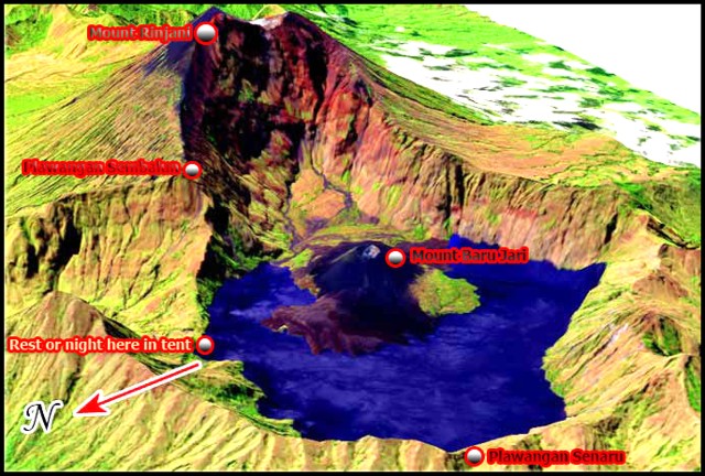 |
Figure 9. Diagram of Rinjani showing the Barujari volcanic cone surrounded by Lake Segara Anak. Courtesy of Bohari Adventures. |
According to a 4 May news article in the Jakarta Post, the first 2 May eruption consisted of four tectonic earthquakes, each lasting between 70 and 120 seconds. Heriyadi Rachmat, head of the East Nusa Tenggara province's mining, energy and mineral resources agency, stated in the article that "the peak of the activity was on Saturday 2 May with four tremors and the eruption of thick ash." This activity prompted CVGHM to raise the Alert Level from 1 to 2 (on a scale of 1 to 4). The head of the Mt. Rinjani National Park confirmed that, as of 3 May, the park had been officially closed to hikers. At that time, around 50 hikers were asked to come down from the mountain. Rinjani, a popular tourist destination, attracts an average of 9,000 hikers per year, 4,000 of whom are foreigners.
During May and June 2009, seismic activity consisted of numerous eruption signals, while observers saw ash plumes, incandescent material, and lava flows (table 3). CVGHM recorded the largest numbers of seismic signals between 7 and 31 May. In detail, during that interval there were 1,897 eruptive earthquakes, 2,163 low-frequency earthquakes, 1,341 harmonic tremor episodes, 3,249 air blasts, 17 shallow volcanic earthquakes, 39 deep volcanic earthquakes, seven local tectonic earthquakes, and three long-distance tectonic earthquakes. Although the volcano was frequently obscured by fog, people still saw impressive eruptions from the observation post at Sembalun Lawang. They noted continuous eruptions with ejected glowing material reaching 200 m in height above the vent, and thrown laterally out to a radius of 500 m from the summit. A great amount of ash, cinders, and incandescent material fell into the caldera, while smaller fragments were blown away.
Table 3. Earthquakes, tremor (both harmonic and non-harmonic with variable maximum amplitudes and durations), air blasts, and other observations between 2 May and 21 June 2009. Key: LD is long distance tectonic, SV is shallow volcanic, LT is local tectonic, DV is deep volcanic. Courtesy of CVGHM and the Darwin VAAC.
| Date | Eruptive earthquake | Low-frequency tremor | Harmonic tremor | Airblasts | Other earthquakes | Observations |
| 02 May 2009 | -- | -- | -- | -- | -- | Dense brown ash plume to 4.7 km altitude; booming noise. |
| 03 May 2009 | 21 | 13 | -- | -- | -- | Recorded during 1800-2400. |
| 04 May 2009 | 85 | 12 | 1 | 7 | 1 LD | Ash eruption produced white to brown plume to 4.2-4.4 km altitude, drifting N. |
| 05 May 2009 | 83 | 2 | 45 | -- | -- | -- |
| 06 May 2009 | 83 | 22 | 30 | 53 | Three volcanic | -- |
| 07 May 2009 | 92 | 43 | 29 | 88 | -- | Recorded between 0000 and 1800; thick white plume. |
| 07-31 May 2009 | 1,897 | 2,154 | 1,341 | 3,249 | 17 SV, 39 DV, 7 LT, 3 LD | 163 eruptions with dense white and gray plumes rising to 3.8-4.1 km altitude. |
| 01-06 Jun 2009 | 240 | 569 | 493 | 316 | 5 SV,10 DV, 2 LT, 6 LD | -- |
| 07-15 Jun 2009 | -- | Continuous | -- | -- | 3 DV | Dense white plumes to 1.3-2.7 km altitude. |
| 16 Jun 2009 | -- | Continuous | -- | -- | 1 LD | Dense white plumes to 1.3-1.5 km altitude. |
| 21 Jun 2009 | -- | -- | -- | -- | -- | Ash plumes to altitude of 3.0 km; drifted N. |
Lava flowed into the caldera lake and then extended 100 m beyond the shoreline. CVGHM and Darwin Volcanic Ash Advisory Center (VAAC) reports also noted several ash plumes over the summit, including those of dense white and grayish color that rose 50-400 m above Sembalun Lawang observatory from 7 May through 29 May.
Potential hazards. As of 16 June 2009, the status of Rinjani remained at Alert Level 2. CVGHM recommended remaining at least 4 km from the Barujari vent, noting potential risks from ashfall and incandescent rocks both within the caldera and in the surrounding areas (figure 10). In addition, CVGHM cautioned that landslides could enter Lake Segara Anak, causing an overflow that could form lahars.
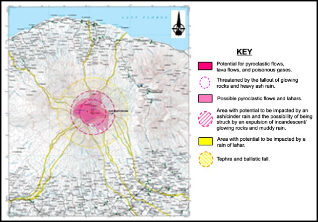 |
Figure 10. A hazard map showing risk areas at Rinjani. Note the lahars extend beyond the two concentric circular areas, reaching the sea on the N to NW outer flanks. Date of publication and exact details of authorship uncertain. Courtesy of CVGHM. |
Geological Summary. Rinjani volcano on the island of Lombok rises to 3726 m, second in height among Indonesian volcanoes only to Sumatra's Kerinci volcano. Rinjani has a steep-sided conical profile when viewed from the east, but the west side of the compound volcano is truncated by the 6 x 8.5 km, oval-shaped Segara Anak (Samalas) caldera. The caldera formed during one of the largest Holocene eruptions globally in 1257 CE, which truncated Samalas stratovolcano. The western half of the caldera contains a 230-m-deep lake whose crescentic form results from growth of the post-caldera cone Barujari at the east end of the caldera. Historical eruptions dating back to 1847 have been restricted to Barujari cone and consist of moderate explosive activity and occasional lava flows that have entered Segara Anak lake.
Information Contacts: Center of Volcanology and Geological Hazard Mitigation (CVGHM), Jalan Diponegoro 57, Bandung 40122, Indonesia (URL: http://vsi.esdm.go.id/); Darwin Volcanic Ash Advisory Centre (VAAC), Bureau of Meteorology, Northern Territory Regional Office, PO Box 40050, Casuarina, NT 0811, Australia (URL: http://www.bom.gov.au/info/vaac/); The Jakarta Post (URL: http://www.thejakartapost.com/news/2009/05/04/mt-baru-jari-spews-ash.html); Rinjani Trekking Centre, Jalan Barakuda 10, BTN Griya Batu Bolong Senggigi, Senggigi-West Lombok 83355, Lombok-NTB-Indonesia (URL: http://www.rinjanimountain.com/rinjani-information-center.htm); Bohari Adventures, Jalan Cendrawasih 8, Cakranegara Mataram 83231, Lombok-NTB-Indonesia (URL: http://www.trekkingrinjani.com/).