Report on Tungurahua (Ecuador) — July 2009

Bulletin of the Global Volcanism Network, vol. 34, no. 7 (July 2009)
Managing Editor: Richard Wunderman.
Tungurahua (Ecuador) Eruptions in 2008-2009; two fatalities in sudden flood on 22 August 2008
Please cite this report as:
Global Volcanism Program, 2009. Report on Tungurahua (Ecuador) (Wunderman, R., ed.). Bulletin of the Global Volcanism Network, 34:7. Smithsonian Institution. https://doi.org/10.5479/si.GVP.BGVN200907-352080
Tungurahua
Ecuador
1.467°S, 78.442°W; summit elev. 5023 m
All times are local (unless otherwise noted)
Our previous report on Ecuador's Tungurahua (BGVN 33:06) summarized the ongoing activity through mid-February 2008. This report covers February 2008-July 2009. The Instituto Geofísico-Escuela Politécnica Nacional (IG) has maintained a continuous watch on Tungurahua in order to provide immediate alert of significantly heightened activity to prevent as much damage to property and population as possible. Several pyroclastic flows occurred.
Steam and ash plumes have been continuous since early 2008. These plumes have generally risen to ~8-9 km with occasional higher plumes as a result of increased activity. Ashfalls were frequently associated with the steam, gas and ash emissions, and deposited small layers of the larger particles downwind, sometimes 8-11 km from the crater. On 1 March 2009, an explosion produced a significant plume that rose to an altitude of ~10 km and drifted NW. By 3 March, the ash on the volcano's W side covered at least 2.5 km2 of cropland, and additional cattle-grazing pasture.
Ashfall accumulation (figure 41) was recorded for a time interval slightly before the current reporting interval, but the available later maps were similar. Towns affected on figure 41 included Choglontús, El Manzano, Palitahua, Cahuají, Sabañag, Santa Fe de Galán, Penipe, and Bayushig. Lighter ashfall was also repeatedly noted in Riobamba and Guano.
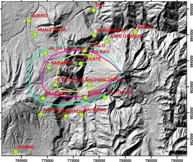 |
Figure 41. Ashfall accumulated from Tungurahua eruptions during 30 January-10 February 2008. N is towards the top and the horizontal scale can be read from to the index marks on the map's margin, which are at 5-km intervals. The three isopachs shown represent thicknesses of 1, 2, and 3 mm (increasing thickness inward). Courtesy of IG. |
On various occasions, incandescence and the ejection of large blocks were Strombolian in character. Roaring, explosions, and "cannon shot" noises were reported almost daily. On 4 August 2008 one explosion was heard as far away as Ambato, 31 km to the NW.
Lahars, floods, and two fatalities. Lahars or mudflows descended drainages to the NW, W, SW, and S repeatedly during the reporting period (many times per week). On 8 March 2008, lahars transported blocks up to 3 m in diameter; in many other cases the largest blocks were around 1 m in diameter. Lahars occasionally affected roads in the Pampas sector to the S and disrupted the access road to Baños.
On 21 August 2008, intense rains prompted the Volcanic Observatory of Tungurahua (OVT) to issue a warning of potential lahars in the Vascún river. A natural dam in that river had been previously identified as a potential hazard.
On 22 August, the dam ruptured and a flood descended. A bridge crossing the river on the outskirts of Baños endured the flooding but was overridden by ~ 20 cm above the railing (figure 42). The flood also destroyed two homes and the El Salado public pools, 1,700-1,800 m downstream of the dam (figure 43). Two people were reported injured and two were reported missing and presumably killed.
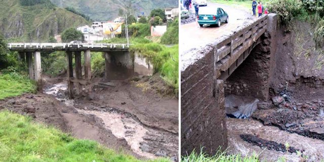 |
Figure 42. (left) A view of a bridge impacted by the Tungurahua flood and lahar of 22 August 2008. A vertical support appears damaged. (right) A smaller bridge showing high water mark about 1 m above the road. On the far bank is scouring near the base, and above that, fresh deposits, including some on the guardrail. The lahar may have caused or contributed to damage on abutment and horizontal support beam, which appears battered and deformed. Courtesy of IG. |
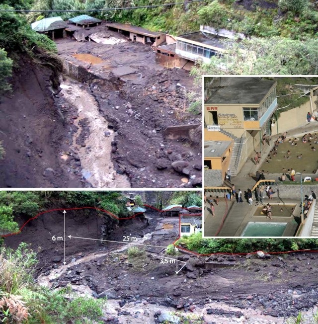 |
Figure 43. Three photos of the El Salado pool facility on the N flank of Tungurahua, where an August 2008 flash flood destroyed significant portions of the buildings and the retaining wall, and gravels swept as high as the roof of some buildings. (top) An overview of the ruined pool facility. (bottom) Measurements help convey the scale of the river's high stand and aftermath. IG authors also sketched a line showing the highest water level. Inset photo was taken when the pool was in use prior to the flood; the river is at right out of view. Courtesy of IG. |
Lahars on 23 October again descended the Vascún river, causing a landslide and rupturing a water pipe that serviced Baños. On 1 November, lahars descended multiple drainages, carrying blocks up to 1 m in diameter to the SW. Residents bordering the Vascún river temporarily evacuated, but returned after the rain stopped.
Pyroclastic flows and explosive activity. Explosive activity continued through the reporting period, including pyroclastic flows. Noteworthy pyroclastic flows occurred on 29 May 2008, when they descended the N and NW flanks of Tungurahua, with deposits observed the next day. In July 2008, a pyroclastic flow was associated with significant ash and tephra fall (with grains up to ~ 3 mm in diameter) reported in the towns of Cahuají, Chazo, Palestina, Santa Fe de Galán, and Guaranda.
Explosions often ejected incandescent blocks that rolled downslope; on 21 June 2009, lava fountains that rose to a height of 500 m above the crater expelled incandescent blocks that were later discovered as far as 2 km downslope. Notable pyroclastic flows, explosions, as well as some lahars and ash plumes were reported (tables 16 and 17).
Table 16. Tungurahua behavior during 19 February-30 December 2008. Only selected examples of near-daily lahars are shown. A map and table of Tungurahua's drainages (quebradas) and surrounding towns appeared previously (BGVN 29:01); locations mentioned include the Mapayacu and Choglontus drainages to the SW; the Pampas sector to the S; Cusúa, 7 km to the NW; Manzano, 8 km to the SW; and the particularly vulnerable city of Baños, 8 km to the N. Courtesy of IG.
| Date | Observations |
| 19, 20, 25 Feb 2008 | Lahars affected roads in Pampas sector |
| 06 and 08 Mar 2008 | Lahars descended W and S drainages; some carried blocks up to 3 m in diameter |
| 25 Mar 2008 | Explosions; incandescent blocks from summit fell on flanks |
| 09, 12, 13 Apr 2008 | Lahars and mudflows on S and NW drainages that disrupted the access road to Banos |
| 21 Apr 2008 | A lahar disrupted the Ambato-Banos road for a few hours |
| 23 Apr 2008 | Blocks rolled 600 m down the flanks |
| 01 May 2008 | Explosions and intense summit incandescence; windows vibrated in areas 6 km NE |
| 11 May 2008 | Blocks rolled ~1 km down the flanks |
| 12 May 2008 | Explosion; rockfalls occurred in an area 8 km to the S |
| 17-18 May 2008 | Explosion similar to that on 12 May; windows rattled in areas to the SW and W |
| 19 May 2008 | Large explosion; numerous incandescent blocks rolled ~1.6 km down the flanks |
| 22, 25-27 May 2008 | Windows vibrated in nearby areas, including at the observatory (OVT) in Guadalupe |
| 23 May 2008 | Marked increase in explosions, ash plumes, and ashfall; summit incandescence at night |
| 29 May 2008 | Pyroclastic flows descended the N and NW flanks, with deposits observed the next day |
| 15 Jun 2008 | Lahars descended the NW and S drainages and resulted in a road closure to the S |
| 19 Jun 2008 | Blocks ejected 500 m above the summit and rolled ~1 km down the flanks |
| 20 Jun 2008 | Mudflow to the SW towards the Puela river carried blocks up to 80 cm in diameter |
| 31 Jul, 03-04 Aug 2008 | Blocks rolled ~1 km downslope; ashfall to SW and W; an explosion on the 4th |
| 19-22 Sep 2008 | Small mudflows in the W and NW; a lahar 50 cm thick to the S |
| 23 Oct 2008 | Muddy waters caused a landslide and a ruptured water pipe that serviced Banos |
| 01 Nov 2008 | Lahars carried blocks ~50-70 cm in diameter in Juive, La Pampas, and Bilbao |
| 04 Nov 2008 | Light ashfall was reported in Pallate and part of Riobamba |
| 15 Dec 2008 | An ash column rose to ~1 km |
| 15-24 Dec 2008 | Ash columns reached a height of ~6 km |
| 17, 21-23 Dec 2008 | Ejecta visible from Guadalupe Observatory |
| 23 Dec 2008 | Incandescent material rolled down flanks |
| 24 Dec 2008 | Small pyroclastic flow on NW flank; incandescent lava flowed down one of the flanks |
| 25-26, 28-30 Dec 2008 | Blocks rolled 500 m downslope on 25 Dec, 1,500 m on 29 Dec, and 800 m on 30 Dec; heavy black ash fell in areas to the SW |
Table 17. Tungurahua behavior during 2 January-7 July 2009. Only selected examples of near-daily lahars are shown. Courtesy of IG.
| Date | Observations |
| 02-04 Jan 2009 | Blocks rolled ~800 m down the flanks; Strombolian activity on 4 Jan |
| 07, 10 Jan 2009 | Incandescent blocks rolled down flanks |
| 08 Jan 2009 | Continuing gas-and-vapor emission; ash columns less than 2 km high drifted W, NW, SW, and NE. Ashfall in El Manzano, Choglontus, Palictahu and Cahuaji |
| 16 Feb 2009 | Ash emissions that generated a plume with altitude of ~8 km and drifted W |
| 01 Mar 2009 | Ash plume that rose to an altitude of ~10 km and drifted NW |
| 03 Mar 2009 | Ashfall covering at least 2.5 km2 of cropland and additional cattle-grazing pasture |
| 21 Mar 2009 | Lahars carried blocks up to 30 cm in diameter to the SW |
| 26 Mar 2009 | Lahar in the Mapayacu drainage carried blocks up to 2 m in diameter |
| 06 Apr 2009 | Fumarolic plumes rose 500-600 m; light ashfall reported 8 km SW |
| 14 Apr 2009 | A steam-and-gas plume containing some ash rose to an altitude of ~7.5 km and drifted N |
| 22 Apr 2009 | Incandescent blocks ejected from the crater and rolled down flanks |
| 06 May 2009 | Ashfall reported in Banos, ~8 km to the N |
| 13, 18 May 2009 | A fine layer of ash fell in Manzano, 8 km to the SW |
| 24-26 May 2009 | Incandescence from the crater seen and blocks rolled 100-500 m down the flanks |
| 27 May-02 Jun 2009 | Strombolian activity |
| 21 Jun 2009 | Lava fountains rising to a height of 500 m above the crater |
| 02, 05-07 Jul 2009 | Lahars descended SW and W drainages carrying blocks up to 40 cm in diameter |
Geological Summary. Tungurahua, a steep-sided andesitic-dacitic stratovolcano that towers more than 3 km above its northern base, is one of Ecuador's most active volcanoes. Three major edifices have been sequentially constructed since the mid-Pleistocene over a basement of metamorphic rocks. Tungurahua II was built within the past 14,000 years following the collapse of the initial edifice. Tungurahua II collapsed about 3,000 years ago and produced a large debris-avalanche deposit to the west. The modern glacier-capped stratovolcano (Tungurahua III) was constructed within the landslide scarp. Historical eruptions have all originated from the summit crater, accompanied by strong explosions and sometimes by pyroclastic flows and lava flows that reached populated areas at the volcano's base. Prior to a long-term eruption beginning in 1999 that caused the temporary evacuation of the city of Baños at the foot of the volcano, the last major eruption had occurred from 1916 to 1918, although minor activity continued until 1925.
Information Contacts: Geophysical Institute (IG), Escuela Politécnica Nacional, Apartado 17-01-2759, Quito, Ecuador (URL: http://www.igepn.edu.ec/); Washington Volcanic Ash Advisory Center, Satellite Analysis Branch (SAB), NOAA/NESDIS E/SP23, NOAA Science Center Room 401, 5200 Auth Rd, Camp Springs, MD 20746, USA (URL: http://www.ospo.noaa.gov/Products/atmosphere/vaac/).