Report on Langila (Papua New Guinea) — November 2009
Bulletin of the Global Volcanism Network, vol. 34, no. 11 (November 2009)
Managing Editor: Richard Wunderman.
Langila (Papua New Guinea) Strong ash explosions during 20-24 September 2009
Please cite this report as:
Global Volcanism Program, 2009. Report on Langila (Papua New Guinea) (Wunderman, R., ed.). Bulletin of the Global Volcanism Network, 34:11. Smithsonian Institution. https://doi.org/10.5479/si.GVP.BGVN200911-252010
Langila
Papua New Guinea
5.525°S, 148.42°E; summit elev. 1330 m
All times are local (unless otherwise noted)
Although the Rabaul Volcano Observatory (RVO) reported ash eruptions and glow as late as 23 February 2008 (BGVN 33:02), subsequent available reports did not include Langila until July 2008. That report noted weak emissions of light gray ash clouds during 1-6 July, followed by white vapor for the remainder of the month, with no glow observed. Activity at Langila was again not described in available observatory reports until September 2009, and thermal anomalies were noted in early October 2009.
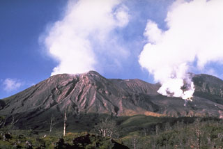
Vulcanian activity occurred from Crater 2 throughout September and the first week of October. From the beginning of September emissions consisted of light brown to dense pale white/gray ash clouds that rose 800-1,000 m above the crater rim. Occasional roaring and rumbling noises were heard. This eruptive episode produced significant amounts of ash, primarily affecting areas NW, W, and SW of the volcano.
Stronger activity during 20-24 September consisted of dense dark gray ash clouds and some incandescent ejections. Plumes rose 2,000-3,000 m above the rim during this period. The emissions also produced continuous roaring noises and booming explosion sounds. Some lightning discharges accompanied the explosions. GNS of New Zealand and the Darwin VAAC detected very strong airborne sulfur dioxide (SO2) in satellite data on 26 September. On-site observations did not indicate strong activity that day, so it was thought to have been from the 20-24 September activity.
Emissions subsided on 25 September to the previous level, and continued during the first week of October, then declined to continuous white-gray ash clouds. This type of activity, with plume heights around 600 m, continued with minor variations until the end of October. The audible noises declined to occasional weak roaring after the first week of October. Night-time glow was also visible throughout September and October.
Some plumes during this episode extended great distances downwind, prompting aviation warnings. Based on analyses of satellite imagery, the Darwin VAAC reported that on 12 September an ash plume rose to an altitude of 3 km and drifted 35 km W. On 29 September ash plumes rose to altitudes of 2.4-4.3 km and drifted 75-220 km NW. Another ash plume the next day drifted 260 km NW at an altitude of 4.3 km. A diffuse ash plume on 5 October rose to an altitude of 3 km and drifted 185 km N.
Thermal anomalies identified in MODIS data were recorded on 10, 22, and 26 September, and 5-6 October. MODVOLC alert pixels appeared to be located outside of the crater on the ENE slope.
Geological Summary. Langila, one of the most active volcanoes of New Britain, consists of a group of four small overlapping composite basaltic-andesitic cones on the lower E flank of the extinct Talawe volcano in the Cape Gloucester area of NW New Britain. A rectangular, 2.5-km-long crater is breached widely to the SE; Langila was constructed NE of the breached crater of Talawe. An extensive lava field reaches the coast on the N and NE sides of Langila. Frequent mild-to-moderate explosive eruptions, sometimes accompanied by lava flows, have been recorded since the 19th century from three active craters at the summit. The youngest and smallest crater (no. 3 crater) was formed in 1960 and has a diameter of 150 m.
Information Contacts: Rabaul Volcano Observatory (RVO), PO Box 386, Rabaul, Papua New Guinea; Darwin Volcanic Ash Advisory Centre (VAAC), Bureau of Meteorology, Northern Territory Regional Office, PO Box 40050, Casuarina, NT 0811, Australia (URL: http://www.bom.gov.au/info/vaac/); Hawai'i Institute of Geophysics and Planetology (HIGP) Thermal Alerts System, School of Ocean and Earth Science and Technology (SOEST), Univ. of Hawai'i, 2525 Correa Road, Honolulu, HI 96822, USA (URL: http://modis.higp.hawaii.edu/).

