Report on Augustine (United States) — August 2010
Bulletin of the Global Volcanism Network, vol. 35, no. 8 (August 2010)
Managing Editor: Richard Wunderman.
Augustine (United States) Shallow earthquakes during September 2007; improved monitoring infrastructure
Please cite this report as:
Global Volcanism Program, 2010. Report on Augustine (United States) (Wunderman, R., ed.). Bulletin of the Global Volcanism Network, 35:8. Smithsonian Institution. https://doi.org/10.5479/si.GVP.BGVN201008-313010
Augustine
United States
59.3626°N, 153.435°W; summit elev. 1218 m
All times are local (unless otherwise noted)
Low-level activity at Augustine declined during the latter half of 2006 through January 2007 (BGVN 31:12, 31:04). By August 2006, seismicity was near background levels. The Alaska Volcano Observatory (AVO) noted ongoing degassing and a small seismic increase in late 2007 and into 2008.
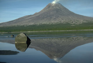
AVO raised the Volcanic Alert Level to Advisory and the Aviation Color Code to Yellow on 22 September 2007. This increase was prompted by an increase in seismic activity below the summit during the previous week. During 22-25 September 2007, the earthquakes were generally less than M 1 and were located at shallow depths beneath the summit. According to AVO, seismic activity remained slightly above background levels into January 2008. Images of Augustine in October 2008, August 2009, and August 2010 showed degassing (figure 33).
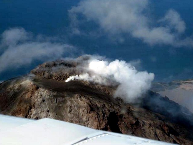 |
Figure 33. Aerial photo of Augustine taken on 19 August 2010 showing the summit amid moderately strong fumarolic degassing. Courtesy of Taryn Lopez and AVO/ USGS. |
Despite its relative calm, Augustine was selected as one of Alaska's potentially most hazardous volcanoes, and the USGS announced in August 2009 that Federal stimulus funds would "raise monitoring up to optimal levels" at the Cook Inlet volcanoes of Augustine, Spurr, and Redoubt (figure 34).
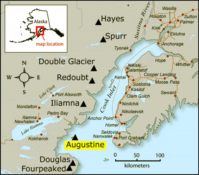 |
Figure 34. Map of the Alaskan Cook Inlet area, indicating the location of Augustine and nearby volcanoes and towns. Courtesy of Janet Schaefer and AVO / Alaska Division of Geological & Geophysical Surveys. |
Increased monitoring may include direct measurements at fumaroles of temperature and gas chemistry (e.g., thermocouple data and SO2 measurements with an ultraviolet spectrometer), as well as sampling gases in an evacuated chamber for later analysis in a laboratory (figure 35).
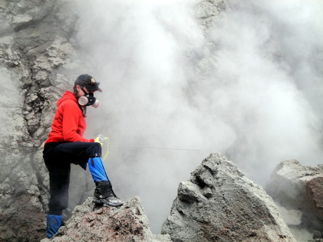 |
Figure 35. Photo of Taryn Lopez engaged in field work at a fumarole next to Augustine's summit. Although the photo was not dated, the caption noted that her work was ARRA-funded, so the photo must have been taken after mid-2009. Photo from the USGS Multimedia Gallery. |
The USGS press announcement stated that "Volcano monitoring is only effective if linked to rapid means for communication of hazard information to communities, businesses, government agencies, and the public. ARRA [stimulus] funds will be used to modernize instrumentation and information systems to state-of-the-art, providing the necessary tools to communicate hazard information quickly to those who need it."
Geological Summary. Augustine volcano, rising above Kamishak Bay in the southern Cook Inlet about 290 km SW of Anchorage, is the most active volcano of the eastern Aleutian arc. It consists of a complex of overlapping summit lava domes surrounded by an apron of volcaniclastic debris that descends to the sea on all sides. Few lava flows are exposed; the flanks consist mainly of debris-avalanche and pyroclastic-flow deposits formed by repeated collapse and regrowth of the summit. The latest episode of edifice collapse occurred during Augustine's large 1883 eruption; subsequent dome growth has restored the edifice to a height comparable to that prior to 1883. The oldest dated volcanic rocks on Augustine are more than 40,000 years old. At least 11 large debris avalanches have reached the sea during the past 1,800-2,000 years, and five major pumiceous tephras have been erupted during this interval. Recorded eruptions have typically consisted of explosive activity with emplacement of pumiceous pyroclastic-flow deposits followed by lava dome extrusion with associated block-and-ash flows.
Information Contacts: Alaska Volcano Observatory (AVO), a cooperative program of a) U.S. Geological Survey, 4200 University Drive, Anchorage, AK 99508-4667 USA (URL: http://www.avo.alaska.edu/), b)Geophysical Institute, University of Alaska, PO Box 757320, Fairbanks, AK 99775-7320, USA, and c)Alaska Division of Geological & Geophysical Surveys, 794 University Ave., Suite 200, Fairbanks, AK 99709, USA; Taryn Lopez, Alaska Volcano Observatory, Geophysical Institute, UAF, Fairbanks, Alaska, USA.