Report on Heard (Australia) — September 2010
Bulletin of the Global Volcanism Network, vol. 35, no. 9 (September 2010)
Managing Editor: Richard Wunderman.
Heard (Australia) Quiet, with minor thermal anomalies, since March 2008
Please cite this report as:
Global Volcanism Program, 2010. Report on Heard (Australia) (Wunderman, R., ed.). Bulletin of the Global Volcanism Network, 35:9. Smithsonian Institution. https://doi.org/10.5479/si.GVP.BGVN201009-234010
Heard
Australia
53.106°S, 73.513°E; summit elev. 2745 m
All times are local (unless otherwise noted)
According to Matt Patrick (USGS) in a report dated 25 October 2010, satellite imagery has not detected unambiguous eruptive activity at Heard since March 2008. No MODVOLC thermal anomalies have been detected since that time, and recent cloud-free ASTER images generally lacked indications of eruptive activity. Given Heard's isolation, satellite imagery provides the only regular information on its behavior. As previously reported, numerous anomalies had been noted in 2006 and 2007, clearly indicating eruptions (BGVN 31:05, 31:11, 32:03, and 32:06). Rare thermal anomalies were recorded through 2 March 2008, with sufficient radiance and extent to suggest eruptions (BGVN 33:01).
Patrick found recent ASTER images that include faint thermal anomalies. The anomalies appeared at Big Ben volcano's Mawson Peak, which is both the volcano's and the island's summit, and hosts the active vent. The most recent cloud-free image, taken on 25 February 2010 (figure 15), shows a small (2-3 pixels in size) thermal anomaly, indicating either very low-level activity or simply warm ground in and around the vent.
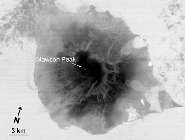 |
Figure 15. ASTER image of Heard on 25 February 2010, showing a thermal anomaly (image based on Aster band 14, 11-micron wavelength). Courtesy of Matt Patrick (USGS) and the ASTER project. |
Geological Summary. Heard Island on the Kerguelen Plateau in the southern Indian Ocean consists primarily of the emergent portion of two volcanic structures. The large glacier-covered composite basaltic-to-trachytic cone of Big Ben comprises most of the island, and the smaller Mt. Dixon lies at the NW tip of the island across a narrow isthmus. Little is known about the structure of Big Ben because of its extensive ice cover. The active Mawson Peak forms the island's high point and lies within a 5-6 km wide caldera breached to the SW side of Big Ben. Small satellitic scoria cones are mostly located on the northern coast. Several subglacial eruptions have been reported at this isolated volcano, but observations are infrequent and additional activity may have occurred.
Information Contacts: Matthew R. Patrick, Hawaiian Volcano Observatory (HVO), U.S. Geological Survey, PO Box 51, Hawai'i National Park, HI 96718, USA (URL: https://volcanoes.usgs.gov/observatories/hvo/); Hawai'i Institute of Geophysics and Planetology (HIGP) Thermal Alerts System, School of Ocean and Earth Science and Technology (SOEST), Univ. of Hawai'i, 2525 Correa Road, Honolulu, HI 96822, USA (URL: http://modis.higp.hawaii.edu/); ASTER (Advanced Spaceborne Thermal Emission and Reflection Radiometer), Earth Remote Sensing Data Analysis Center (ERSDAC) in Japan, and the Jet Propulsion Laboratory in the U.S. (URL: http://asterweb.jpl.nasa.gov/).