Report on Sarychev Peak (Russia) — September 2010
Bulletin of the Global Volcanism Network, vol. 35, no. 9 (September 2010)
Managing Editor: Richard Wunderman.
Sarychev Peak (Russia) Lava flows on the E and SE flanks; aerosol layer detected by lidar
Please cite this report as:
Global Volcanism Program, 2010. Report on Sarychev Peak (Russia) (Wunderman, R., ed.). Bulletin of the Global Volcanism Network, 35:9. Smithsonian Institution. https://doi.org/10.5479/si.GVP.BGVN201009-290240
Sarychev Peak
Russia
48.092°N, 153.2°E; summit elev. 1496 m
All times are local (unless otherwise noted)
Since the last eruption at Sarychev Peak, during 11-21 June 2009 (BGVN 34:06), there have been intermittent thermal anomalies detected and one ash plume. Later fieldwork also revealed lava flows from the 2009 activity. This volcano lacks a seismometer, so satellite observations are the Sakhalin Volcanic Eruptions Response Team's (SVERT) primary monitoring tool, as they are for many volcanoes of the Kuril Islands.
The June 2009 explosive eruption deposited pyroclastic flows and associated tephra that changed the landscape around on NE Matua Island. Hot pyroclastic flows completely buried vegetated slopes, covered wide areas to the W, N, and E, and reached the sea (BGVN 34:06).
Satellite imagery collected after June 2009 revealed lava flows on the E and SE flanks. Some imagery and photos (including radar and thermal data) and a lidar atmospheric sounding found aerosols interpreted as Sarychev Peak ash at 12 km altitude over Germany.
Additional June 2009 eruption observations. Gas-and-steam emissions were frequent in July 2009, possibly with some ash on the 27th (table 1). Low-altitude plumes were visible up to 75 km away. Thermal anomalies were then detected on 21 November 2009, and 3 February, 9 March, and 27 May 2010. An ash plume was seen on 20 September 2010.
Table 1. Emissions and plumes from Sarychev Peak during July 2009-September 2010. Courtesy of SVERT.
| Date | Activity |
| 04-05 Jul 2009 | Gas-and-steam emission, plumes drifted 20-75 km NW, NE, and SE to altitudes of 1.5-3 km. |
| 08 Jul 2009 | Gas-and-steam emission, plumes drifted 15 km E. |
| 09 Jul 2009 | Gas-and-steam emission, plumes containing some ash drifted 50 km E. |
| 13 Jul 2009 | Gas-and-steam emission, plumes drifted 40 km E. |
| 14 Jul 2009 | Gas-and-steam emission, plumes drifted 25 km W and NW. |
| 15-21 Jul 2009 | Gas-and-steam emission, plumes drifted 30-50 km W and S. |
| 22 Jul 2009 | Gas-and-steam emission, plumes drifted 35 km N. |
| 27 Jul 2009 | Steam-gas plume possibly containing some ash drifted 55 km NW at 3.7 km altitude. |
| 21 Nov 2009 | Thermal anomaly, steam-gas emission. |
| 03 Feb 2010 | Thermal anomaly. |
| 09 Mar 2010 | Thermal anomaly. |
| 27 May 2010 | Thermal anomaly. |
| 20 Sep 2010 | Diffuse ash plume. |
As previously discussed (BGVN 34:06), a scientific expedition from the Institute of Marine Geology and Geophysics Far East Division Russian Academy of Sciences (FED RAS) and Pacific Institute of Geography (FED RAS) that visited the island during 26-28 June 2009 described the eruption as explosive in character (Levin and others, 2009). Also, the explosions were sufficiently strong to have created a deep crater. A 2007 photo of the summit crater disclosed a shallow depression, the floor of which was covered in pyroclastic material (figures 14 and 15). More recent images show a newly deepened and enlarged crater (figures 16 and 17).
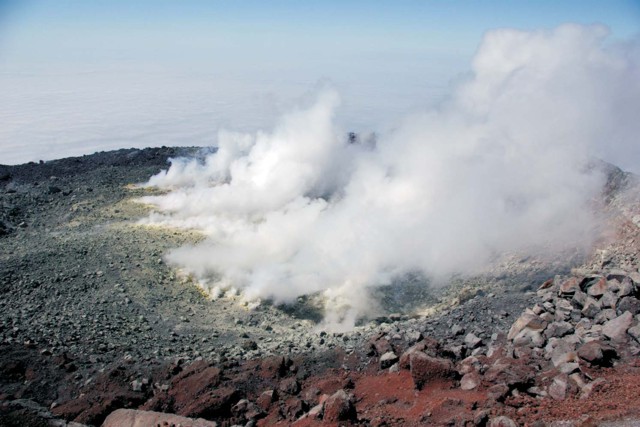 |
Figure 14. Sarychev Peak's summit crater as photographed in August 2007. Pyroclastic materials and solidified lava then filled the summit crater of the volcano to its lowest level on the NW edge. Note the large area of steaming and the crater's shallow depth and pan-like character. Courtesy of A. K. Klitin. |
 |
Figure 15. Almost a year after Sarychev Peak erupted spectacularly during June 2009, it displayed only degassing with steam hanging over the newly enlarged summit crater. The Advanced Land Images (ALI) on NASA's Earth Observing-1 (EO-1) satellite captured this image on 11 June 2010. Steam filled the summit crater, forming an almost perfect circle of white. A much fainter, barely discernible plume blew away from the summit toward the E. Courtesy of NASA Earth Observatory. |
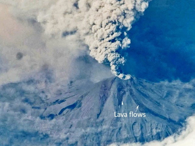 |
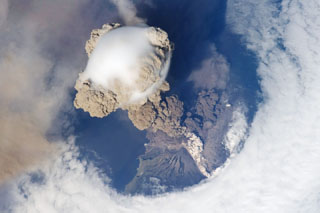
Figure 16. Sarychev Peak's new lava flows appear in this image from 17 June 2009. This and other photos were taken with a hand-held camera from the International Space Station. From Grishin and Melekestsev (2010). |
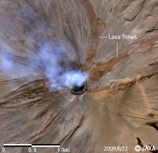 |
Figure 17. A 22 June 2009 satellite image of Sarychev Peak, zooming in on the upper slopes and clearly showing the lava flows, a passively steaming crater, and, within the summit crater, a new deep and steep-sided explosion crater. In the NE direction, the larger crater has a diameter (rim-to-rim) of ~350-450 m. Within that lies the steep-sided crater, which has a diameter of ~250 m. Courtesy of JAXA. |
Satellite images from 17-18 June 2009 (such as figure 16) disclosed two, roughly 100- to 150-m-wide streams of lava that first divided ~300 m from the crater's NE edge. More detailed satellite images (including thermal images) and photos from the field analyzed after the expedition also aided the recognition of the lava flows. Grishin and Melekestsev (2010) noted that the new lava flows extended 2.4 and 2.6 km from their source at the summit crater. The area of the lava flows was estimated as 0.8 km2; the volume was estimated as ~10 x 106 m3.
Analysis also determined that the lava flows proceeded downslope during the eruption's active phase. Field photos disclosed that the pyroclastic deposits overlapped and were coeval with the lava flows. In other words, lava flows moved roughly synchronous with the pyroclastic flows (figures 16 and 17).
In some images, fresh snow had blanketed and remained over the bulk of Matua Island, but the lava flows and thick pyroclastic flows remained devoid of, or with limited, snow cover. This effect was attributed to continued heat radiating from the lava flows and thick pyroclastic flows.
Satellite radar. Japan Aerospace Exploration Agency (JAXA) staff performed radar observations on 19 June 2009 (figure 18) using the Phased Array Type L-band Synthetic Aperture Radar (PALSAR) installed on the Advanced Land Observing Satellite (ALOS). Analysts compared an earlier radar image, from 14 March 2007, to detect surface changes between those two dates; many of the changes were attributed to the 2009 eruption (figure 18).
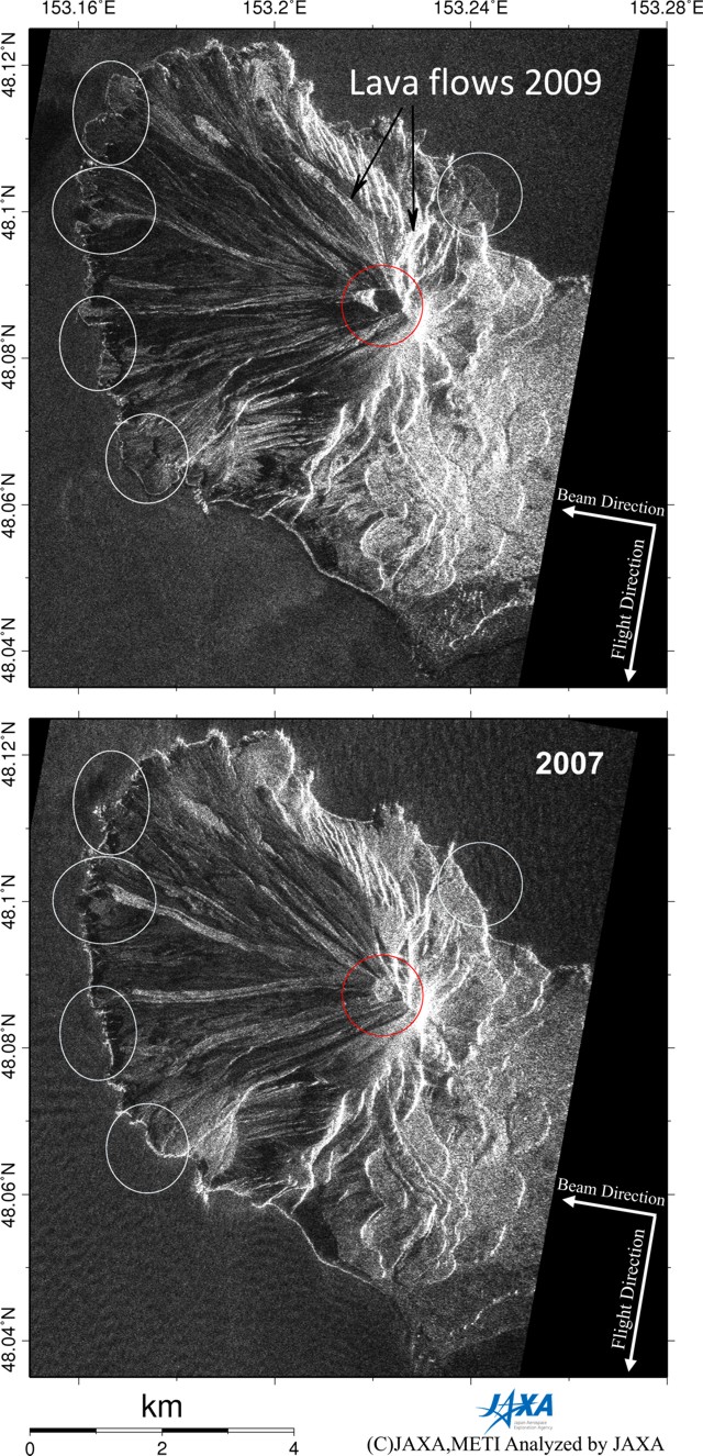 |
Figure 18. PALSAR amplitude images acquired before (bottom; on 14 March 2007) and after (top; on 19 June 2009) the eruption at Sarychev Peak. The same observational modes were used for both images (taken on descending orbit with an off-nadir angle of 34.3 degrees). PALSAR radar depict the target area without masking by weather clouds, steam or other volcanic gases. Courtesy of JAXA. |
The two images revealed areas with profound changes (circled) both around the crater and at many points along the coast. Analysts interpreted the shoreline changes as due to pyroclastic flows or lahars, which issued from the crater and transported material radially. On the upper slopes, the strong radial pattern was primarily due to pyroclastic flows and, in some locations, lava flows.
Lidar. Mattis and others (2009) discussed aerosol data from lidar soundings over Leipzig, Germany, during the summer of 2008 through the first half of 2009. They associated high backscatter seen on 1 July 2009 with aerosols from Sarychev Peak's eruption and estimated the main peak from aerosols as residing at ~12 km altitude.
Earlier backscatter peaks were attributed to Okmok (Aleutians, 15-km altitude); Kasatochi (Aleutians, 15.2 km); Shiveluch (Kamchatka, 8.8 km); Cleveland (Aleutians, 6 km); and Redoubt (Alaska, 20 km). The authors noted that, prior to the onset of the aerosol layers seen in the summer of 2008, their measurements in the previous 12 years lacked any major effects from volcanic aerosols over Germany.
References. Grishin, S.Yu., Melekestsev, I.V., 2010, Lava flows from the 2009 eruption of Sarychev Peak, the Central Kuriles, Bulletin of Kamchatka Regional Association "Educational Scientific Center"; Earth Sciences, no. 1 (15), p. 232-239.
Levin, B.V., Rybin, A.V., Razzhigaeva, N.G., and others, 2009, Complex Expedition of the "Volcano-Sarychev 2009" (Kuril Islands), Bulletin Far East Division, Russian Academy of Sciences, no. 6, p. 98-104.
Mattis, I., Seifert, P., Muller, D., Tesche, M, Hiebsch, A., Kanitz, T., Schmidt, J., and Finger, F., 2009, Volcanic aerosol layers observed with multi-wavelength Raman lidar over Europe since summer 2008, in Proceedings of the 8th International Symposium on Tropospheric Profiling, Delft, The Netherlands, October 2009. Eds. A. Apituley, H.W.J. Russchenberg, W.A.A. Monna, ISBN 978-90-6960-233-2.
Geological Summary. Sarychev Peak, one of the most active volcanoes of the Kuril Islands, occupies the NW end of Matua Island in the central Kuriles. The andesitic central cone was constructed within a 3-3.5-km-wide caldera, whose rim is exposed only on the SW side. A dramatic 250-m-wide, very steep-walled crater with a jagged rim caps the volcano. The substantially higher SE rim forms the 1496 m high point of the island. Fresh-looking lava flows, prior to activity in 2009, had descended in all directions, often forming capes along the coast. Much of the lower-angle outer flanks of the volcano are overlain by pyroclastic-flow deposits. Eruptions have been recorded since the 1760s and include both quiet lava effusion and violent explosions. Large eruptions in 1946 and 2009 produced pyroclastic flows that reached the sea.
Information Contacts: Sakhalin Volcanic Eruptions Response Team (SVERT), Institute of Marine Geology and Geophysics (IMG&G) Far East Division Russian Academy of Sciences (FED RAS), 1B Science St., Yuzhno-Sakhalinsk, 693022, Russia (URL: http://www.imgg.ru/); B.W. Levin, A.V. Rybin, M.V. Chibisoba, and V.B. Gur'yanov, IMG&G; N.G. Razzhigaeva, Pacific Institute of Geography FED RAS, 7 Radio St., Vladivostok, 690041, Russia (URL: http://tig.dvo.ru/tig/); S. Yu. Grishin, Institute of Biology and Soil Science FED RAS, 159 Prospect Stoletiya, Vladivostok, 690022, Russia; I.V. Melekestsev, Institute of Volcanology and Seismology FED RAS; A.K. Klitin, Sakhalin Research Institute of Fisheries and Oceanography, Yuzhno-Sakhalinsk, Russia; Gennady Padalka, Frank De Winne, Roman Romanenko, Robert Thirsk, Michael Barratt, Nicole Stott, Tim Kopra, and Koichi Wakata (astronauts), International Space Station Expedition 20 (URL: http://www.nasa.gov/mission_pages/station/expeditions/expedition20/, http://www.eorc.jaxa.jp/ALOS/img_up/l_pan_sarychev_090622.htm); NASA Earth Observatory (URL: http://earthobservatory.nasa.gov/).