Report on Karisimbi (DR Congo-Rwanda) — October 2010
Bulletin of the Global Volcanism Network, vol. 35, no. 10 (October 2010)
Managing Editor: Richard Wunderman.
Edited by Jen Fela.
Karisimbi (DR Congo-Rwanda) Rain-triggered mudflow causes 50 reported deaths in May 2010
Please cite this report as:
Global Volcanism Program, 2010. Report on Karisimbi (DR Congo-Rwanda) (Fela, J., and Wunderman, R., eds.). Bulletin of the Global Volcanism Network, 35:10. Smithsonian Institution. https://doi.org/10.5479/si.GVP.BGVN201010-223040
Karisimbi
DR Congo-Rwanda
1.506°S, 29.45°E; summit elev. 4490 m
All times are local (unless otherwise noted)
The following report describes a mudflow that caused 50 deaths on 16 May 2010 on the outer W flank of Karisimbi, a complex volcano with steep upper slopes and the tallest of the Virunga volcanoes (figure 1). The first section was summarized from early reports by relief organizations. The second section is from a later report by Innocent Badryio (United Nations Office for Project Services, UNOPS), Benoít Smets (Royal Museum for Central Africa), and Dario Tedesco (Department of Environmental Sciences, University of Naples, Italy), which clarified the source of the event after field and remote sensing surveys.
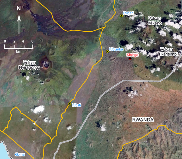 |
Figure 1. Annotated satellite image showing location of Kibiriga village situated ~6.5 km to the W of Karisimbi volcano and ~6.2 km SW of Mikeno volcano. Nyiragongo volcano is visible ~16 km W of Karisimbi. Date and type of imagery is unknown. Mudflows are not readily apparent in the image either because of issues such as cloud cover and resolution or most likely because the image was collected prior to the event. Note that international boundary lines often are drawn imperfectly on many satellite images and are unconfirmed here. Courtesy of OCHA. |
Available reports did not attribute the mudflow to eruptive processes, seismicity, or gas emissions. Some early reports cited the sudden release of water from a crater lake, but that idea was later discounted. The later report (by Badryio, Smets, and Tedesco) attributed the mudflow to multiple factors, including heavy rains carrying loose debris into the regional drainage system. In addition, satellite images discussed in the later report revealed that the mudflows were more complex than the three branches that were reported initially (figure 2). Note that international boundary lines are not in agreement between figures 1 and 2.
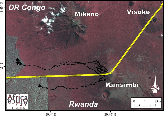 |
Figure 2. Map showing the various branches of mudflows found to the W of Karisimbi volcano on 16 May 2010. Satellite data revealed that the flows were more complex than the three branches originally reported based on field observations. Note that international boundary lines often are drawn imperfectly on many satellite images and are unconfirmed here. Courtesy of Benoít Smets. |
Initial reports. UNOPS reported that human casualties and extensive property damage occurred on 16 May 2010, when a mudflow occurred ~6.5 km W of Karisimbi. The flow, composed of mud, tree debris, rock, and soil, occurred between 0000 and 0100, in the locality of Kibiriga, in the area of Kibumba, on the border of the DR Congo and Rwanda (figure 1). UNOPS described the affected area as "situated between a steep slope (45%) on the flank of Karisimbi and Mikeno to the NE and a sort of plain having a 10% steeper slope to the SW."
UNOPS reported that the mudflow was preceded by torrential rains that began at 2200 on 14 May and lasted until 0550 on 16 May. Based on initial field interpretation, UNOPS described the flow as "subdivided in three directions, with a thickness ranging between 0.3 to 4 m and a width of 50 to 150 m. The length of the flow could surpass 1 km, from the edge of Virunga Park, situated upstream from the locality, to the alluvial cone downstream."
Volcanic rocks were carried by the mudflows in some areas (figure 3). One branch of mud and debris, in the direction from NE to SW, flowed through part of Kibiriga village, causing human casualties and extensive damage to homes and crops (figures 4 and 5). The extent of the damage was due to a combination of factors, including the steep slope above the village, the amount and type of soil that was washed down the slope, and the type of housing in the area. Rising population densities have led to the destruction of forest and vegetation in the area, which may have contributed to the event.
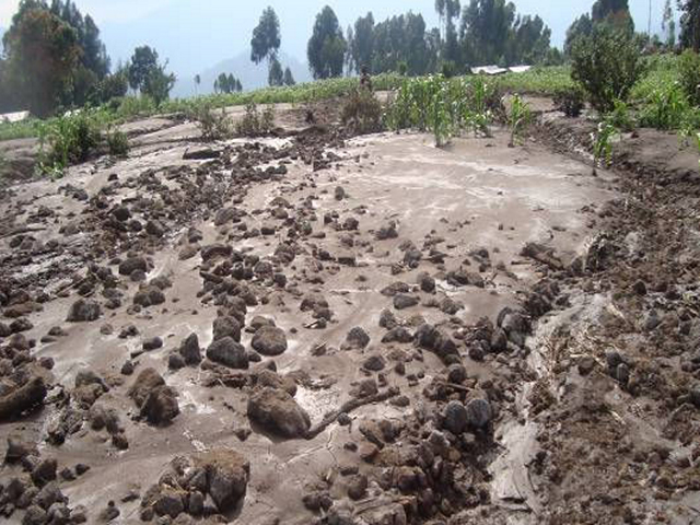 |
Figure 3. Volcanic rocks (on the order of decimeters) were carried by the mudflows in some areas near Karisimbi volcano on 16 May 2010. Courtesy of UNOPS. |
Figure 4 illustrates that houses in the area were substantial, built of mud bricks and wood. They contained large vertical timbers and horizontal interlacing branches of substantial strength. However, the houses proved unable to resist the impact of the deep and fast-moving mudflows, which UNOPS reported to flow at speeds higher than 50 km/hour in some places. Given the speed and because the flow occurred at night when residents were sleeping, they had little chance to escape.
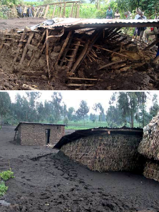 |
Figure 4. Mud flowed through homes in Kibiriga village near Karisimbi on 16 May 2010. Because of the high speed and because the flow occurred at night, many residents could not escape. Courtesy of UNOPS. |
Witnesses observed layers of older mudflows in the beds of two new streams after the event, which they interpreted to mean that similar events have occurred in the past. An elderly witness stated that similar events occurred in 1951, 1956, 1970, and 1994, but without casualties or much damage. This person also reported that the odor "of a pigsty" accompanied the 2010 mudflow. UNOPS stated that the mudflow was accelerated and especially violent because of the presence of volcanic ash and pieces of lava in the soil, and that similar events have occurred in the area every 12 years, on average.
Later analysis based on satellite data. Badryio, Smets, and Tedesco confirmed that such events are not unusual in the Virunga region and have occurred several times during the last century. This is because the main edifices of dormant volcanoes in the Virunga volcanic chain (in DR Congo, Rwanda, and Uganda) are cut by networks of deep gullies serving as ephemeral streams carrying water and debris from a large area. During exceptionally heavy rains, torrents are able to mobilize large amounts of unconsolidated pyroclasts and soil. The streams develop fast-moving and potentially devastating mudflows.
The extremely heavy, but not unusual, rainfalls that occurred in the Virunga region during April to May 2010 triggered several mudflows in DR Congo, and damage also occurred in neighboring Rwanda. Badryio, Smets, and Tedesco reported that the 16 May mudflow in the village of Kibiriga killed ~50 people and destroyed 232 houses and 7 hectares of crops. This particular mudflow reached at least 3 m deep and carried large blocks, including rocks more than 2 m wide.
Before this event, this hazard was poorly understood, and the origin of the mudflows was misattributed to drainage of a lake located in the Muntango crater (S crater of Karisimbi). Later field and remote sensing surveys coupled with a bibliographic review led to a revised description of the event and its impact. The mudflows were mapped using satellite images (EO1-ALI) that were geographically corrected (orthorectified) using other data. A 2.5-m resolution image (SPOT) and digital elevation model (DEM) were used for interpretation of the relief and the hydrographic networks. Based on the satellite data, scientists concluded that the lake in the Muntango crater was not the source of the mudflows.
Satellite imagery also revealed that the paths of the mud were more complex than three single branches (figure 2). The mudflows in Kibiriga followed the existing hydrographic network until they reached human-modified soils, where the mud spread laterally in several branches.
 |
Figure 5. A woman with child looks over a field covered with mud from the 16 May 2010 mudflow near Kibiriga village on the W flank of Karisimbi. The event caused human casualties and destroyed 7 hectares of crops. Courtesy of UNOPS. |
Scientists concluded that there is a danger of similar future events in this region, especially because of the exponential demographic and urban growth coupled with deforestation and the subsequent increase in soil erosion. UNOPS suggested a cartographic study to delineate zones at risk for future similar events.
Geological Summary. Karisimbi is a complex basanitic-to-trachytic volcano with a symmetrical sharp-peaked summit. The 2-km-wide Branca caldera, located SE of the summit, is filled by viscous lava flows and two explosion craters. The large 1.2-km-wide Muntango pit crater is located south of the summit. A broad lava plain, formed from lava flows erupted within the caldera and along a chain of cones, extends SW. More than 100 cones erupted along a NNE-SSW zone that extends to the shores of Lake Kivu. The youngest Potassium-Argon date obtained is about 10,000 years before present (de Mulder, 1985). The youngest eruptions produced a group of dome-shaped vents east of the caldera, which fed viscous lava flows that traveled as far as 12 km E, and lava flows from the SW-flank lava vents.
Information Contacts: Innocent Badryio, United Nations Office for Project Services (UNOPS), Goma, Democratic Republic of Congo; Benoít Smets, Royal Museum for Central Africa, Department of Earth Sciences, Tervuren, Belgium; Dario Tedesco, Department of Environmental Sciences, University of Naples 2, Caserta, Italy; Observatoire Volcanologique de Goma, Departement de Geophysique, Centre de Recherche en Sciences Naturelles, Lwiro, D.S. Bukavu, DR Congo; United Nations Office for the Coordination of Humanitarian Affairs (UNOCHA), Kinshasa, DR Congo; World Health Organization, Bureau Du Representant De L’oms En Republique Democratique Du Congo (RDC), 42, Avenue des Cliniques, Gombe, Kinshasa.